Ipswich, Suffolk, England - part 2
- May 1, 2025
- 99 min read
Updated: Sep 1, 2025
Military:
Transport:
Sport:
People:
Geography:
Modern Day:
County Town of...
Why not also visit www.planetsuffolk.com - Bringing together the Suffolks of the world
Ipswich Barracks
During the late eighteenth century, fears of an invasion of Britain by the French, coupled with the convenient situation of the town’s port for embarkation to the continent, resulted in large numbers of troops being billeted in Ipswich. In 1795, the first permanent barracks were built in the town, in the area just north of the St Matthew’s Street/Norwich Road junction (still known locally as Barrack Corner), on the site of the present day residential streets of Cecil Road, Geneva Road & Barrack Lane.
Known originally as the Horse Barracks, the first regiment to move in were the 2nd or Queen’s Regiment of Dragoon Guards. They were succeeded by other cavalry regiments until, in the second half of the nineteenth century, artillery regiments such as the Royal Field Artillery & the Royal Horse Artillery took over. St Matthew’s became the garrison church, with troops parading through the streets to the church each Sunday morning.
The 2 ½ acre site initially consisted of a large parade ground, surrounded on three sides by the barrack rooms & officer’s mess. In early 1855 the barracks were rebuilt. The Illustrated London News of 17th February 1855 described the new barracks as “the first that have been erected upon a regularly fortified plan”. The Barracks were closed & demolished around 1929, at which time the land was acquired by Ipswich Borough Council for residential development. Parts of the barrack walls are still in evidence at the bottom of some of the gardens of the houses in Geneva Road & Cecil Road, & in Barrack Lane gate posts still exist with stone balls on top & inscriptions on the pillars (see photo, left).
Around the time of the Napoleonic Wars, there were also two other less permanent barracks in the town. One was known as Stoke Barracks, situated in the maltings buildings off Wherstead Road (now Felaw Maltings), which were converted for the purpose. The buildings reverted to maltings around 1813. There is no visible evidence today of the second site; a wooden hutted camp known as St Helen’s Barracks that was situated just north of Woodbridge Road, in the vicinity of Brunswick Road, Belvedere Road (formerly Parade Field Terrace) & Parade Road. This too closed about 1813.
The Loyal Ipswich Volunteer Corps

In 1794 Ips wich Corporation put forward a proposal to raise an Ipswich Regiment of regular troops. Although this plan never came to fruition, an internal defence force known as the Loyal Ipswich Volunteer Corps was proposed & came into being in that same year. This was in response to the growing threat of an invasion by France during the War of the First Coalition, (1793-97) which followed the French Revolution, & the later Napoleonic Wars (1803-1815), during which time many towns raised their own defence forces.
Although the troops were part time volunteers, the Loyal Ipswich Volunteer Corps were willing to take garrison duty if required. They received new colours in 1803, in which year they spent three weeks on permanent duty in Hadleigh. A further three weeks of permanent duty followed at Ipswich barracks in 1805.
The Corps’ first taste of serious action, however, came not from a foreign invasion force, but a much more local source, when in 1800 the Volunteers were called out to quell a riot at Stoke Mills, caused by protests over inflationary prices after seven years of war. Initially being pelted with bags of flour from the mill, the trouble shifted to St Peter’s churchyard, where the Volunteers found themselves under fire from rocks & bricks. The crowds were eventually dispersed when cavalry troops from the barracks were called in.
There is very little information available about the demise of the Loyal Ipswich Volunteer Corps, although it seems likely to have been disbanded around the year 1816, after the threat of invasion had diminished.
(You may also be interested in the sections on the Suffolk Regiment & Reserve Forces in Britain Bearing the Name Suffolk, on the Suffolk Misc. page of Planet Ipswich’s sister site www.planetsuffolk.com).
The Ipswich Mutiny - 1689
It is a little known fact that an army mutiny at Ipswich was instrumental in a change of military law.
When King James II fled Britain in December 1688, William of Orange and his wife, Mary, the daughter of James II, became king and queen, thus ensuring the Protestant ascendancy in the country. William had come to Britain accompanied by his Dutch guards and most of the troops in Britain went over to his side. However, the loyalty of some of the British forces, particularly the Scots, still seemed favourably disposed to the cause of King James. The government resolved to retain the Dutch troops in England, and send over to the Netherlands, in case of French intervention, those British regiments that were considered the most disaffected.
Therefore, on 8th March 1689 certain regiments were ordered to march to the sea coast, and embark for the Netherlands. Of these the Scottish regiment of Dumbarton mutinied on its march to Ipswich on 12th March whilst the Royal Scots, already at Ipswich, mutinied on 14th March. The mutineers seized the military chest, disarmed the officers who opposed them, declared for King James and, with four pieces of cannon, 800 men marched out of the town to make their way to Scotland. King William ordered General Ginckel to pursue them with three regiments of Dutch dragoons, and the mutineers quickly surrendered. As the mutineers were citizens of Scotland, which had not yet agreed to the new government, the king did not wish to punish them as rebels, but ordered them to proceed to the Netherlands.
Though this attempt proved abortive, it made a strong impression upon parliament since it appeared that the mutineers had not actually done anything seriously wrong. The army was under the control of the monarch in respect of his sovereign prerogative and acted in accordance with military law as laid down by articles. However, these articles of war could not prevail over common law in England, and whilst in England the soldiers remained subject to common law and were still regarded as civilians. These rights could only be over-ruled when the soldiers were overseas or if martial law applied in times of war, and Britain was not in a state of actual war. Punishment that might “endanger life or limb” was the preserve of common law, so the military could not take immediate action to discipline the men while in England and at a time of peace.
It seemed that the men, being civilians, could just walk away and return home. There may have been remedies under common law for breach of their contract with the sovereign, or theft of military equipment, but this was a slow and cumbersome procedure. Parliament felt that soldiers who mutinied, stirred up sedition or deserted should be brought to “a more exemplary and speedy punishment than normal civil law would allow”. Therefore, a bill was introduced and passed all its stages with rapidity, receiving royal assent on 28th March, and became effective on 12th April 1689. The British Mutiny Act of 1689 provided the discipline needed for a standing army in times of peace, and initiated modern Anglo-American military law. It allowed a court-martial to take life or limb in cases of proven mutiny, sedition or desertion. And it all began at Ipswich.
Railways
Proposals to bring rail travel to Suffolk, & Ipswich in particular, can be dated back to the mid 1820s, when an abortive attempt at setting up a railway company was made. This occurred in February 1825, when a meeting in the Shire Hall, chaired by Rev. Dr. John Chevallier of Aspall Hall, Suffolk, proposed plans to set up a company that was to have been known as the Ipswich and Suffolk Railway Company. The proposal was for a line that connected Ipswich with the Suffolk town of Eye, & then onwards to Diss in Norfolk. This, & a further attempt to bring the railway to Suffolk in 1833, failed to get off the ground.
The prospects of rail lines being laid on Suffolk soil really began to take shape in 1834, however, when the Grand Eastern Counties Railway proposed to build a line from London to Great Yarmouth. Although the company’s bill was successfully introduced into the House of Commons in 1836, with work beginning on the line in the following year, by 1838 it had been decided that, due to lack of funds, the line would terminate at Colchester. Many of the directors of the Eastern Counties Railway (ECR; the ‘Grand’ having by now been dropped), were from other parts of Britain & were therefore unconcerned about where the line ended, providing it proved profitable. Three of the directors, however, were Suffolk men, & they fought for the continuation of the line into Suffolk. John Chevallier Cobbold (see The Cobbold Family section, below), together with his father John & uncle the Rev. Dr. John Chevallier (see above), had been some of the earliest champions of rail travel & were determined that Suffolk should not miss out.
Being a minority on the ECR board, they were continually being outvoted, however, & by the early 1840s it became apparent that the only way forward was for the formation of a new company; the result of which was the birth of the Eastern Union Railway Company (EUR). For this project, the EUR hired Peter Bruff as the company’s chief engineer, & he proposed a different route from that originally planned by the Eastern Counties Railway. Bruff’s route crossed the River Stour into Suffolk at Cattawade, reaching Ipswich via Brantham, Bentley & Belstead. The Eastern Union received the go-ahead from parliament in July 1844 (despite opposition from the now rival Eastern Counties Railway Company), with work on the line from Colchester to Ipswich commencing almost immediately. A subsidiary company, the Ipswich and Colchester Railway, was set up to build the line.
The Ipswich to Colchester line was opened with great ceremony on 11th June 1846, with a special train running to Colchester from Stoke Station; at that time the northern terminus of the line, located in the vicinity of today’s Station Street & Croft Street (to the east of Stoke Hill & the present station). The journey took around 1 ½ hours. The public passenger service commenced four days later on 15th June, with stops at Ardleigh, Manningtree and Bentley. Relations between the EUR & the rival ECR, at the confluence of their lines at Colchester, were always uneasy. Passengers journeying from Ipswich to London had to change to ECR trains at Colchester, & the ECR made connections as difficult as possible, using such tactics as altering its timetable & ordering its ticket inspectors & clerks to make life awkward for passengers wishing to change trains. Under no circumstances were Eastern Union trains allowed onto the lines built by Eastern Counties. The dispute between the two companies would last until 1854, when the Eastern Union was taken over by the Eastern Counties, although it would be a further eight years until the companies were formally merged in 1862 as the Great Eastern Railway (GER).
In July 1845 the Ipswich and Bury Railway Company (I&BR) had been formed to extend the line a further 26.5 miles from Ipswich to Bury St Edmunds. Although a separate company, the I&BR had many shareholders and directors in common with the EUR, as well as sharing offices, & the two companies formally amalgamated in 1847. It was the Ipswich and Bury Railway Company who built the tunnel under Stoke Hill, just to the east of today’s station. Being on a sharp curve, the tunnel was the first of its kind ever attempted. Opened in early December 1846 for freight transport, a passenger service commenced on the line from the 24th of that month. Stations along the route were located at Needham Market, Stowmarket, Haughley, Elmswell & Thurston.
In 1846, a venture was authorized to build a new junction at Haughley, with an extension line to the junction with the Norfolk line at Trowse, to the south of Norwich, which would then connect to Norwich Victoria station. This was built by the Ipswich and Norwich Railway, another subsidiary company of the EUR. The line opened in stages, finally being completed on 12th December 1849. Once again, the opening of this line brought the EUR into confrontation with their rivals the ECR, who already ran a service to Norwich via Cambridge.
A proposal for a rail service from Ipswich to Woodbridge had first been muted in 1847, with the Ipswich and Bury Railway having secured the rights to build the line. Financial constrictions, however, caused the postponement of these plans. In 1859, the Ipswich and Woodbridge Railway, a subsidiary of the Eastern Counties Railway, was set up to build a line that would link the East Suffolk Line at Woodbridge with Ipswich & the main line to London. The line opened in June 1859.
Ipswich Station: The station at Stoke Hill, to the east of the tunnel, served as Ipswich station from 1846 until July 1860. The reason for its location here, away from the town centre, was due to its convenience for passengers transferring from the steamboats that docked on Stoke Quay (close to today’s Steamboat Tavern on the New Cut West). With the construction of the new station at the other, western, end of the tunnel, the Stoke Station closed, although the site remained in use as a railway siding & engine shed until the 1980s, when the lines were removed for development into a residential area. One of the roads in this area has been named Bruff Road, after the engineer responsible for bringing the railways to Ipswich.
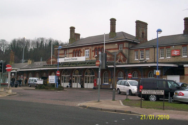
The present station (see photo, above) was built on the western side of the tunnel, & opened in July 1860, with the island platform being built in 1883. Located on Burrell Road close to the junction with Princes Street, the station now serves the Great Eastern Main Line from London Liverpool Street to Norwich. It is estimated that around 3 million passengers use the station annually.
For details of other railways in Suffolk, see the Railways section on the Suffolk, England page of www.planetsuffolk.com
Ipswich Airport
Ipswich Airport was located on 144 acres of land in the far southeast corner of the Borough of Ipswich. Established in 1930, the Ipswich Municipal Aerodrome, as it was then known, was opened on 26th June of that year by the future King Edward VIII, who was Prince of Wales at the time. He described the new airfield as “one of the finest in the country”. His brother, Prince George (King George VI after Edward’s abdication), also flew into the airport less than a month later. Throughout its existence, the airport was always predominantly used by privately owned & flying club operated aircraft, although passengers services did fly during the first decade of the airport’s existence, & again after the war, to such destinations as Southend, Ramsgate & the Channel Islands.
The start of the Second World War, however, saw the abrupt cessation of all civilian flights. With the beginning of hostilities, the RAF took immediate control of the airport, which became a satellite base for RAF Wattisham, around 15 miles from Ipswich. No. 110 squadron quickly moved its Bristol Blenheim IV bombers to Ipswich, & aircraft flying from Wattisham & Ipswich are thought to have mounted the first air raid of the war; an attack on German warships in Schillig Roads (the approaches to the Jade Bight and Wilhelmshaven in Lower Saxony on Germany’s North Sea coast).

Despite a new terminal building being opened in 1938, & plans for expansion being mooted on several occasions, these schemes never came to fruition & the airport was earmarked by Ipswich Borough Council for closure in 1993; the reason given being that the land was needed for housing development. Ironically, the early 1990s had been some of the busiest years for the airport, which now included a parachute centre & helicopter school, & hosted regular airshows. Campaigns to keep the airport open, however, resulted in a stay of execution until the Civil Aviation Authority delicensed the airport on 31 December 1996. Even so, efforts were made to keep the airfield open, until the last plane finally departed in January 1998.
The terminal building (see photo, above), which was declared a Grade II listed building in 1996, lay derelict for several years before being developed into a community centre and apartments for the new Ravenswood housing estate, which has now been built on the site of the airport.
Ipswich Racecourse
The site of Ipswich Racecourse was situated in the east of the modern day town, in the area now known as the Racecourse estate. With a total length of one mile seven furlongs, the course ran along modern day Lindberg & Cobham Roads, then parallel to Felixstowe Road as far as Hatfield Road, before looping around & running parallel with Nacton Road for the six furlong finishing straight. The finishing line is said to have been in the vicinity of the Racecourse pub on Nacton Road, which was demolished in 2009.
The first recorded race meeting was held in 1710, & for over 170 years both flat & National Hunt racing took place here. Ipswich Races gained in stature in 1727, when a Royal Plate worth 100 guineas was awarded. In 1775 a gallery was erected, followed a year later by a covered structure called the ‘Gentlemen’s Stand’. Support steadily declined in the late nineteenth century & the final flat race was run in 1884, although the course continued as a National Hunt venue until the last meeting on 29th March 1911.
The First Steeplechase on Record: Also on the subject of horse racing, a popular myth has arisen over the years that Ipswich was the location for the first ever steeplechase to be held in England.
Whether based on fact or fiction, the story goes that on an evening in December 1803, an officer named Hansum from the 7th Hussars Cavalry Regiment stationed at Ipswich, challenged anyone in the regiment to race against his horse across four & a half miles of countryside to Nacton church. Seven others took up the challenge &, dressed in nightshirts over their uniforms, & with nightcaps on their heads, they set off in the moonlight.
The scene was later depicted in a set of four paintings produced in 1839 by Henry Alken, collectively entitled “The First SteepleChase on Record”, which gave rise to the myth. (see Paintings of Ipswich, England album in Photo Gallery).
However, even if this event took place (which is very doubtful), the first recorded steeplechase in England was in 1790 in Leicestershire over 8 miles from Melton Mowbray to Dalby Wood.
Greyhound Racing in Ipswich – Suffolk Stadium
Situated off the Old London Road, just east of Yarmouth Road and close to the river, the first licenced race meeting at the Suffolk Greyhound Stadium took place on 11th September 1935, although contemporary records suggest that racing had taken place here prior to this date. The track at this time had a circumference of 405 yards (370 metres), with races normally being run over 300, 500 and 700 yards. Race meetings were normally held on Wednesday and Saturday evenings, usually with eight races per event.
For many years the stadium operated as an independent track, and only began operating under National Greyhound Racing Club (NGRC) rules in 1974. The most prestigious races run here were the Suffolk Derby, which was run over 440 metres, and the Suffolk St Leger, run over 625 metres.
The last meeting at the stadium was on 17th February 1988, after which the stadium was sold off. The site is now occupied by Suffolk Retail Park.
Ipswich Town Football Club
The name of Ipswich Town Football Club has probably done more than anything else to put the town of Ipswich on the map; not just in the UK, but in Europe & throughout the world.
Founded in 1878 as Ipswich Association Football Club, their first ground was at Brook’s Hall, just off Norwich Road. The club’s first president was T.C. Cobbold (see The Cobbold Family section, below), starting a family association that continues to this day. In 1888, the club changed their name to Ipswich Town, which coincided with a move to Portman Road, where they have been ever since.

In 1936 the club turned professional &, after playing for two seasons in the Southern League, joined the Football League in season 1938-39; playing in the Third Division South.
In 1955, Ipswich acquired the services of Alf Ramsey as their new manager. Then still in the Third Division South, Ramsey led the side to the Second Division title in 1960/61, then to the ultimate prize of First Division Champions in the following year; the club’s first ever season in the top flight of English football. Ramsey left the following season to take over managership of the England national side, which he led to World Cup glory in 1966; a feat for which he was later knighted. After his death in 1999, Portman’s Walk was renamed Sir Alf Ramsey Way & his statue erected at the junction with Portman Road.
Ipswich’s greatest sustained period of success was still in future when Ramsey left, however. The seeds of this success were sown in 1969, when a young manager named Bobby Robson was appointed. After three seasons of struggle against relegation from the First Division, Ipswich finished fourth in the table in 1972/73 & qualified for the UEFA Cup. Until his departure to manage England in 1982, Ipswich would be second only to Liverpool in league consistency; qualifying for European competition in nine out of ten seasons. In season 1977/78 Ipswich beat Arsenal 1-0 at Wembley to lift the prestigious FA Cup for the first & (so far) only time in their history. Three years later, in 1980/81, Ipswich achieved success on the European stage when they beat the Dutch side AZ 67 Alkmaar 5-4 on aggregate i n the UEFA Cup final.

During Robson’s reign, several Ipswich players went on to represent their countries at international level including: Mick Mills, Paul Mariner, Kevin Beattie & Terry Butcher for England, George Burley, John Wark & Alan Brazil for Scotland, Allan Hunter for Northern Ireland & Arnold Muhren & Frans Thijssen for Holland. Robson himself later received a knighthood & the CBE for his services to football. His statue now stands in Portman Road &, since his death in 2009, the North Stand has been renamed The Sir Bobby Robson Stand in his honour. A new footbridge, the Sir Bobby Robson Bridge also opened in 2009 over the river, near to Constantine Road weir.
Since the Robson era, it has been an up & down journey for the club, alternating between spells in the top division & periods in the league below. In 2019 however, they were relegated to League One, the third tier of English football, where they had not played for more than sixty years. However, under current manager Kieron McMckenna they rose again, to win back to back promotions to the Championship in 2022/23 and the Premier League in 2023/24, only to be relegated back to the second tier of English football after only one season in the top flight, for the 2025/26 campaign.
(see Statues, Plaques & Signs:Ipswich, England album in Photo Gallery for pictures of Sir Alf Ramsey, Sir Bobby Robson and Kevin Beattie statues, & Rivers & Bridges:Ipswich, England album for the Sir Bobby Robson Bridge).
Since 1990, outdoor concerts have been staged occasionally on the Portman Road pitch during the summer months. Beginning with Tina Turner, subsequent acts to appear include: Rod Stewart, Status Quo, Dire Straits, Bryan Adams, Elton John, REM & The Red Hot Chili Peppers.
Foxhall Stadium & Ipswich Witches

Foxhall Stadium, situated on Foxhall Road, was opened in 1950 & hosts both stock car racing & speedway. The outer track is a 382 metre tarmac oval & is used for stock car racing. The inner, shale track is used for speedway. The stadium is run by Spedeworth Motorsports & is home to the National Hot Rod World Championships, held over the first weekend in July every year. Other big events are the Gala Night, held on the nearest Saturday to Guy Fawkes Night (5th November) every year, & the Unlimited National Bangers Championship of the World, which is held in October. Other events take place regularly, featuring stock cars, stock rods, superstox, hot rods, bangers & lightning rods, amongst others.
The stadium is shared with the Ipswich Witches speedway team, one of the oldest & most established teams in the country. From 2011 the Witches competed in the British Premier League, having dropped down from the Elite League at the end of the 2010 season. In 2019 the Witches returned to the top flight of British speedway, now known as the SGB Premiership.

The first speedway meeting in Ipswich was held at Ipswich Town FC, in Portm an Road. After plans to build a track in Bramford Road were turned down, Foxhall Stadium was purpose built for speedway & the first meeting took place in 1951; continuing until 1965, when the stadium was converted to a stock car track. In 1969 the inner track was built & speedway recommenced & has been held there ever since. The Witches’ best ever season was 1998, when they won the Elite League, the Knockout Cup and the Craven Shield. Probably Ipswich’s most famous rider is John “Tiger” Louis, who rode in the 1970’s & later became the club’s promoter.
Speedway meetings are normally held on Thursday evenings. The season runs between March & October.
Geoffrey Chaucer
Although most sources state that Geoffrey Chaucer was born in London, there is no evidence of his exact place of birth & it is possible that he was born in Ipswich. The year of his birth is also uncertain, but it is most often recorded as around 1343.
Chaucer’s family kept at least three inns in Ipswich, two of which stood on opposite corners of Tavern & Tower Streets. One of these was run by Geoffrey’s grandfather, the other by his great aunt Agnes. Another relative, Albreda, also kept a hostelry further along Tavern Street. The family name was originally Malyn, & it seems that they were also involved in the shoemaking industry; the name Chaucer deriving from chausseur or shoemaker. Geoffrey’s father John was known to have been in Ipswich after the death of his own father, when his aunt Agnes ‘kidnapped’ him & brought him to Ipswich from London, in the hope of marrying him off to her daughter.
Even assuming that he wasn’t born in Ipswich, from 1374 to 1386 Geoffrey Chaucer was employed as Controller of Customs in the Port of London, & travelled frequently around the country on the King’s business, which would probably have included visiting such an important port & town as Ipswich during the course of his work. This would account for the fact that, in his most famous work, The Canterbury Tales, Chaucer satirises the merchants of Ipswich.

In the general prologue, line 275, speaking of the merchant who later features in The Merchant’s Tale, the River Orwell is mentioned:
"His bootes clasped faire and fetisly. His resons he spak ful solempnely,Sownynge alway th’ encrees of his wynnyng.He wolde the see were kept for any thing Bitwixe Middleburgh and Orewelle." A rough translation from the Middle English is as follows:
"His boots were fastened neatly and elegantly. He spoke out his opinions very solemnly,Stressing the times when he had won, not lost.He wanted the sea were guarded at any costBetween Middleburgh & the Orwell." - Geoffrey Chaucer - Ipswich Library
Cardinal Thomas Wolsey
Thomas Wolsey (or Wulcy as the family spelt the name at the time) was born in Ipswich between 1471 & 1475. His father Robert, an innkeeper & butcher, & his mother Joan, lived at that time near St. Mary Elms church, but moved soon afterwards to St. Nicholas Street where Thomas grew up. A plaque now marks the spot near to where this house stood.
Thomas attended Ipswich School before going on to study theology at Magdalen College, Oxford, where he later became a master. He was ordained in 1498 & became rector of the Church of Saint Mary, Limington, Somerset in 1500, before becoming chaplain to the Archbishop of Canterbury two years later. In 1507 he entered the service of King Henry VII as Royal Chaplain. When Henry VII died in 1509 he was succeeded by his son Henry VIII, who appointed Wolsey to the post of Almoner; a position which gave him a seat on the Privy Council & allowed him to raise his profile & get himself noticed.
Wolsey became a Canon of Windsor in 1511, & in 1514 he was consecrated as a Bishop; being made both Bishop of Lincoln, & then Archbishop of York in that same year. In the following year he was made a Cardinal. The Pope made him Papal Legate to England in 1518, & in 1523 he became Prince-Bishop of Durham.
Running parallel with his religious career, his rise to power in the Royal court saw him become a powerful & controlling figure in most matters of state, & the King's most trusted advisor and administrator. By 1515 he had become Lord Chancellor. Over the next 14 years he gradually destroyed or neutralised many other influential courtiers who he perceived as a threat to his position.
One of his greatest triumphs was arranging the Field of the Cloth of Gold; a meeting between King Henry VIII & King Francis I of France, that took place in June 1520 near Calais. The object of the meeting was to increase the friendship between the two nations following the Anglo-French treaty of 1514.

Wolsey had an interest in architecture; having Hampton Court Palace in Richmond upon Thames built around 1514, as well as rebuilding York Place in Whitehall, London around the same time. Both properties were seized by the King after Wolsey’s downfall.
This came in 1529, when he was unable to get Henry’s marriage to Catherine of Aragon annulled by the Pope. He was stripped of office & had his property confiscated; although he retained his position as Archbishop of York. It was whilst travelling to York in the following year that he was arrested & accused of treason. He died at Leicester on 29th November 1530, on his way to stand trial in London. He was buried in Leicester Abbey.
Wolsey had a great interest in education. In Ipswich he had sought permission to build a school, the aim of which was to act as a feeder for Cardinal College, Oxford (now Christ Church), which he also founded. The site chosen was near St Peter’s Church in what is now College Street, close to the quay. The school opened in 1528, but within a year was being dismantled after his fall from power. All that remains today is the gateway to the Cardinal College of St. Mary, commonly known as Wolsey’s Gate (see photo, above right).

Apart from Wolsey’s Gate, there ar e several other places in Ipswich named either Wolsey or Cardinal in his honour, such as:
Wolsey Street, Cardinal Street, New Cardinal Street, Cardinal House (offices in St Nicholas Street, close to where his house stood), Wolsey House (offices in Princes Street), New Wolsey Theatre (in Civic Drive), & Cardinal Park (leisure complex on Grafton Way, featuring restaurants, bars & cinema).
Sculpted by David Annand, a bronze seated statue of Cardinal Thomas Wolsey was unveiled on 29th June 2011 on Curson Plain, at the junction of Silent Street & St Peter’s Street; close to the site of the house that Wolsey grew up in (see photo, above).
William Shakespeare - The Ipswich Connection
Ipswich is mentioned twice by William Shakespeare in his play King Henry the Eighth, both in relation to Cardinal Wolsey. In Act 1 Scene 1, the Duke of Buckingham, talking about Wolsey to the Duke of Norfolk says:
I’ll to the King, and from a mouth of honour quite cry down this Ipswich fellow’s insolence, or proclaim there’s difference in no persons.
In Act 4 Scene 2, Griffith, Gentleman-usher to Queen Katharine of Aragon, says to her, again referring to Wolsey:
Those twins of learning that he raised in you, Ipswich and Oxford! One of which fell with him, unwilling to outlive the good that did it.
It is thought that Shakespeare may have visited Ipswich on more than one occasion, as part of a travelling troupe of actors, during his early years.
Thomas Eldred
Thomas Eldred was born in 1561 in Brook Street, Ipswich. In July 1586 he was part of Thomas Cavendish’s expedition that set sail from Plymouth on the second English circumnavigation of the world (Drake’s 1577-80 voyage having been the first). Cavendish himself was also a Suffolk man; being born in Trimley, ten miles east of Ipswich. The master of one of the three ships, the Desire, was Thomas Fuller, also from Ipswich. (see also Thomas Cavendish section on the Suffolk, England page of www.planetsuffolk.com)
Upon his return in September 1588, Eldred settled back in Ipswich, where he became a successful merchant; exporting, amongst other things, cloth to the continent. He was elected to the 24 man Council in 1608 & was the town treasurer in 1613-14. In 1620 he became one of the 12 portmen of the town & became eligible for the office of bailiff the following year. He died in 1624 & is buried in St. Clement’s church. For many years he lived in Fore Street &, although the house has since been demolished, the overmantel from the largest room can now be seen in Christchurch Mansion. It features three oil painted panels showing a ship, a globe & Eldred’s portrait.
Until recently his name was commemorated in the Thomas Eldred public house on the corner of Cedarcroft Road & Burke Road. This has, however, been demolished in 2012.
High Steward of Ipswich
The title High Steward is an honorary title given by the local council of some towns or districts of England. It is the highest office that the Council can bestow. Originally this was a judicial office with considerable local powers, although over the centuries the duties of the High Steward have gradually declined, until today the post is largely ceremonial.
Although the practice can be traced back to the Middle Ages, Ipswich began conferring the office of High Steward in 1557. Today, Ipswich is one of 25 communities in England that possess the right to appoint a High Steward, although in some of these locations the practice has fallen into disuse. Ipswich, however, still retains its High Stewardship, which is normally awarded for life. There have been 23 High Stewards of Ipswich.
The office of High Steward of Ipswich was first bestowed on Sir William Cordell in 1557. Cordell (1522–1581) was Solicitor General and Master of the Rolls during the reign of Queen Mary I, & Speaker of the House of Commons during the reign of Queen Elizabeth I. He lived at Long Melford, Suffolk, where he founded the Hospital of the Holy and Blessed Trinity in 1573.
The most famous High Steward of Ipswich was undoubtedly Horatio Nelson, 1st Viscount Nelson, 1st Duke of Bronté (1758 - 1805), best remembered for his service with the Royal Navy during the Napoleonic Wars, & particularly at the Battle of Trafalgar in 1805, during which he lost his life. He was High Steward of Ipswich from 1800-05. (See also Admiral Lord Nelson section, below).

Others to have held the post include:
The 1st, 2nd & 3rd Earls of Suffolk during the seventeenth century
John Chevallier Cobbold from 1875-82 (see The Cobbold Family section, below)
Field Marshal Horatio Herbert Kitchener, 1st Earl Kitchener (1850 -1916), who served in the British Army in the Franco-Prussian War, Second Boer War & First World War, & whose iconic image appears on the much imitated 1914 “Lord Kitchener Wants You” recruitment poster (see right). Although born in County Kerry, Ireland, Kitchener’s mother was Frances Anne Chevallier-Cole of Aspall Hall in Suffolk. His grandfather, the Rev. Dr. John Chevallier, had been one of the leading figures in the fight to bring the railways to Ipswich from the 1820s onwards (see Railways section, above).
The present holder of the office of High Steward of Ipswich is Stuart Whiteley, CBE, QPM, who has held the post since 1990.
Thomas Gainsborough
Born in 1727 in Sudbury, Suffolk, the portrait & landscape painter Thomas Gainsborough lived in Ipswich between 1752 & 1759; at first in Lower Brook Street, then moving to 34 Foundation Street. In 1759 he left Ipswich & moved to Bath.
As well as his famous works such as Mr and Mrs Andrews (1748/49) & The Blue Boy (1770), he also painted landscape scenes of Christchurch Park & Holywells Park in Ipswich (See Paintings of Ipswich, England album in Photo Gallery). He died in London in 1788.
34 Foundation Street was knocked down in the 1960’s, but a commemorative plaque adorns the wall of no.32.
For a more in depth biography of Thomas Gainsborough, see the Suffolk, England page on www.planetsuffolk.com
Holywells Park by Thomas Gainsborough
David Garrick
One of the most influential English actors of all time, David Garrick (1717-79), made his professional debut in Ipswich in 1741, when he appeared with a travelling troupe from London as an African slave named Aboan in Thomas Southerne’s play Oroonoko, or the Royal Slave at the Playhouse in Tankard Street (modern day Tacket Street). At the time he was using the pseudonym Lyddal & he seems to have been lacking in confidence prior to his appearance here, but this was boosted by the reception he received. He played other roles that summer in the town, before returning to London, where he made his debut as Richard III at the Goodman's Fields Theatre, before going on to have a very influential 30 year acting career, as well as being a successful playwright, theatre manager and producer. He died in London & is buried in Poets’ Corner, Westminster Abbey. Several theatres are named after him, the most notable being the Garrick Theatre in Charing Cross Road, London.
Opened in 1736, The Playhouse, or New Theatre, was built by Ipswich merchant & brewer Henry Betts, next to his tavern, The Tankard, in what was then called Tankard Street. It closed in 1892 after the opening of the Lyceum Theatre in Carr Street.
Admiral Lord Nelson
In September 1797 Admiral Lord Horatio Nelson acquired a house in Rushmere Road, Ipswich called Roundwood (since demolished). Set in 50 acres, Roundwood was described as having a “barn, stables, cow-house and other offices and a well-planted garden”. Although he was seldom there, his wife, Lady Nelson, & his father, the Rev. Edmund Nelson, lived there for several years. Nelson sold the house in January 1801.
In 1800, Nelson was appointed High Steward of Ipswich (see above), a position he held until his death. It is also known that Nelson visited the Great White Horse Hotel in Tavern Street in November 1800.
Born in Norfolk, Nelson’s Royal Navy career began in 1771 & he soon began to rise rapidly through the ranks; obtaining his own command in 1778. He was renowned for his inspirational leadership & his grasp of strategy & tactics, winning many important victories & rising to the rank of Admiral. He served during the American War of Independence, the French Revolutionary Wars, & the Napoleonic Wars. Injured several times in the line of duty, he suffered the loss of both one arm & one eye. His most famous victory was at the Battle of Trafalgar in October 1805, in which he received a fatal wound. His funeral was held in St Paul’s Cathedral, London, where his body is interred.
Why not also visit www.planetsuffolk.com - Bringing together the Suffolks of the world
Sir Thomas Slade
Designer of Nelson’s flagship HMS Victory, Sir Thomas Slade (1703/4 - 1771) spent some time early in his career in Ipswich, as surveyor for the Navy Board supervising the ships being built at John Barnard’s shipyard in St Clement’s parish. In 1747 he married an Ipswich woman named Hannah Moore. He later rose to the post of Master Shipwright &, in 1755, was appointed Surveyor of the Navy. Both he & his wife are buried in St. Clement’s churchyard, where a memorial to him now stands.
Ransomes (Ransomes, Sims & Jefferies/Ransomes & Rapier)

Up until the late twentieth century, the names of the firms Ransomes, Sims & Jefferies, and Ransomes & Rapier were known throughout the world for their engineering & machinery; the former company producing ploughs, agricultural implements, lawn mowers, tractors, fork lift trucks & the like; the latter being involved in the manufacture of railway components, cranes, excavators & sluice gates.
Robert Ransome (1753 – 1830), who was born in Wells, Norfolk, set up his first general ironmongery shop in Norwich in 1774; later establishing a foundry there. In 1785 he patented a process for tempering cast iron plough shares, before moving his operations to Ipswich in 1789; probably due to the better port facilities that made the import of raw materials & the export of finished goods easier. Initially setting up at St Mary at the Key, the business soon relocated to a newly built foundry in the area then known as St Margaret’s Ditches (now Old Foundry Road).
Initially called Ransome & Co, the firm became Ransome & Son in 1809 when Robert’s son James became a partner. An ‘s’ was added to become Ransome & Sons in 1818, when James’ younger brother, also called Robert, joined the firm. After the senior Robert Ransome retired in 1825, the firm became J. & R. Ransome, whilst a further name change was required five years later when James’ own son, James Allen Ransome, joined as a partner & the company became J. R. & A. Ransome. It was the younger James who would publish, in 1843, The Implements of Agriculture, which proved to be one of the most popular books on agricultural implements & machinery prior to the age of steam.
Over the course of the nineteenth century, the firm underwent several other names changes as various other partners joined:
Ransomes & May in 1846, when long term employee Charles May became a partner.
Ransomes & Sims in 1852, after James Allen Ransome’s nephew William Sims was invited to become a partner.
Ransomes, Sims & Head in 1869, when John Head became a partner.
Ransomes, Head & Jefferies in 1881, when James Allen Ransome’s son-in-law John Jefferies was made a partner (with William Sims temporarily leaving the business).
And finally Ransomes, Sims & Jefferies in 1884, upon the death of John Head & the return of William Sims. Under this name they would become a limited company in 1911, & the name would remain until 1998.
In 1841, the firm began to move their business to Orwell Works on Duke Street by the docks. This move was completed in 1849, when the foundry in St Margaret’s Ditches finally closed. By this time the firm employed more than a thousand people. The Orwell Works site was in operation until 1966; new premises having been opened in Nacton in 1949, with the business gradually being transferred there. From the 1830s onwards, Ransomes had been manufacturing lawn mowers &, in 1902, produced the first commercial powered lawn mower, driven by an internal combustion engine. They also later went on to produce electric mowers.
Ransomes supplied munitions during both World Wars; manufacturing Royal Aircraft Factory F.E.2 fighter biplanes for the 1914-18 conflict, whilst gun carriages & parts for tanks & aircraft were amongst the armaments produced from 1939 onwards.
In 1987, Electrolux Group bought the agricultural division of the company, leaving Ransomes solely as a lawn mower manufacturing concern. In 1998, a takeover bid was accepted from Textron Inc. Of Providence, Rhode Island, & three years later the company was rebranded Ransomes Jacobsen Ltd, which still survives to this day as part of the Textron Group. Today the company’s site is part of the Ransomes Industrial Estate, also known as Ransomes Europark; a combined retail and business park on the south eastern outskirts of Ipswich.Ransomes & Rapier: Although the Ransomes reputation had been built on ploughs & other farm machinery, with many patents having been taken out from the earliest days, by the 1830’s Ransomes had diversified into other areas, especially the manufacture of railway materials, which were being developed by employee & future partner Charles May at a time when the railways were expanding to cover the whole of Britain. Eventually, in 1869, a separate firm was established named Ransomes & Rapier, which took over the railway side of the business, leaving Ransomes, Sims & Head to concentrate on their agricultural machinery. The latter half of the new firm’s name was derived from Richard Rapier (1836 – 97), who had been in charge of the railway division since 1862.
Ransomes & Rapier moved into the Waterside Works on the Stoke side of the River Orwell, where they went on to produce locomotive turntables, water control & sluice gear, cement mixers & cranes. They also made some of the world’s largest walking draglines for open cast coal mining. They were involved in the construction of the Niagara hydro-electric power station &, in 1902, produced the sluice gates for the Aswan Dam on the River Nile in Egypt. Like their neighbours on the other side of the river, Rapier’s also supplied munitions during the world wars, including shells, guns and tank turrets.
In 1875, Ransomes & Rapier had sent several of their workforce out to China, where they were involved in building the first railway in that country (linking Shanghai with Woosung on the Yangtse River, a distance of around 12 miles). Two engines built in Ipswich were shipped to the Far East to operate on the narrow gauge line. The line, however, was shut down & destroyed the following year for political reasons, after it had been handed over to the Chinese.
Another feat of engineering attributable to Ransomes & Rapier is the turntable built in the 1960s for the revolving restaurant in what was then known as the Post Office Tower in London (now the BT Tower).
Ransomes & Rapier merged with Newton, Chambers & Company of Sheffield in 1958, after which a subsidiary company was formed named NCK-Rapier. When NCK was acquired by Robert Maxwell’s media group, the rights to their walking dragline technology and patents were sold to Bucyrus International of Wisconsin, & in 1988 the Waterside Works in Ipswich closed & Ransomes & Rapier ceased to exist.
The Cobbold Family
Ever since the middle of the eighteenth century, the Cobbold family have played an important part in the development of the Ipswich we see today.
Thomas Cobbold (1680-1752) began brewing at Harwich in 1723, before moving to an existing brewery in Ipswich in 1743. Three years later he built Cliff Brewery on the eas t bank of the River Orwell (see photo, right), & began brewing using waters from the nearby Holywells. Although he died six years later, his son, also named Thomas, continued brewing, as did his own son John on the death of the younger Thomas in 1767.

For more than 250 years the Cobbold name was synonymous with brewing in Ipswich. Merging their business with the Tollemache brewing operation in 1957, the two families ran the business for twenty years, under the name Tolly Cobbold. In its heyday during the 1970s, the company owned around 400 pubs, more than 80 of which were in Ipswich. In 1977 the business was taken over & changed hands several times before it was announced in 1989 that the Cliff Brewery was to close. At this time the brewery was classified as a listed building &, after a successful management buy-out, brewing recommenced once more in 1991; with the building now also housing a brewing museum. It finally closed in 2002. In February 2020 the now derelict building was partially destroyed by fire. (See also “Tolly Follies” in part 1)
John Cobbold (1746-1835) who took over the business on the death of his father, was not only a brewer & maltster, but also had many other business interests in the town such as banking, ship owning & corn merchant. He had Holywells mansion built as the family home around 1814. It was he, along with his second wife Elizabeth, who employed Margaret Catchpole, about whom John’s son, the Rev. Richard Cobbold (1797-1877) wrote a semi-factual account . (See Margaret Catchpole section, below)
Another of John’s sons (he had twenty two children), also named John (1774-1860), together with his son John Chevallier Cobbold (1797-1882), were to become leading figures as Ipswich developed into an industrial centre during the nineteenth century.
John Chevallier Cobbold, who represented Ipswich in parliament during the years 1847-1868, was instrumental, along with his father, in forming the Eastern Union Railway, which brought the railways to Ipswich in 1846. The Eastern Union Railway was established by the father & son partnership when the Eastern Counties Railway decided not to extend their line any further than Colchester. The official opening of the new line took place on 11th June 1846 & was opened for public passengers six days later. The line from Ipswich to Bury St. Edmunds opened in December of the same year & was extended as far as Norwich in 1849. For the next few years there was much rivalry between the EUR & the ECR, until in 1854 the two companies amalgamated, before becoming the Great Eastern Railway in 1862.
As well as the railways, this father & son team were also Dock Commissioners during the period in the late 1830s & early 1840s when the new wet dock was being planned & built. John Chevallier Cobbold was mayor of Ipswich in 1842 when the dock was opened. In 1875 he was made High Steward of Ipswich; a post he held until his death. (See also River Orwell & River Gipping in part 1)
Felix Cobbold (1841-1909), son of John Chevallier Cobbold, is best known for donating Christchurch Mansion to the town; having bought the estate from the Fonnereau family. He also gave land & provided funds for the construction of Fore Street Baths in 1894. He was elected as one of the town’s MPs in 1885 & became mayor of Ipswich in 1896. Two of his brothers, John Patteson & Thomas Clement Cobbold also represented Ipswich in parliament.
From its very earliest days in 1878, the Cobbold family have been influential in the running of Ipswich Town Football Club. The club’s first president was Thomas Clement Cobbold (1833-83), son of John Chevallier Cobbold.
Captain John Murray ‘Ivan’ Cobbold (1897- 1944), grandson of John Patteson Cobbold, became president of the still amateur club in 1935 & then chairman of the new professional Ipswich Town Football Club Ltd in 1936; a position he held until his death during World War II. His sons John & Patrick would both also hold the post of chairman during the club’s most successful period between the 1960s & the 1980s. Ivan Cobbold’s widow, Lady Blanche Cobbold, also served as honorary club president until her death in 1987. Other family members to have served as club chairman are John Patteson’s son Philip Wyndham Cobbold from 1944 to 1945, & his son Alistair Philip Cobbold from 1945 to 1957. (See also Ipswich Town Football Club section, above)
Margaret Catchpole
Margaret Catchpole was born in 1762 in the village of Nacton near Ipswich. In 1793 she found employment in the household of John & Elizabeth Cobbold, who lived at Cliff House, Ipswich, as a nurse & cook; a position she held until 1795. It was during this time that she learned to read & write.
Catchpole’s boyfriend was a smuggler named William Laud, who was a wanted man after shooting another of Margaret’s admirers, John Barry. In May 1797, when she found out that Laud was in London, Margaret stole a horse from her former employers & rode the 70 miles or so to London to meet him. On arrival, however, she was arrested & tried for theft at the Suffolk Summer Assizes at Bury St. Edmunds. Initially sentenced to death, her sentence was commuted to seven years imprisonment at the intercession of the Cobbolds, from whom she had stolen the horse. For three years she seems to have been a model prisoner, until in 1800 she escaped from Ipswich gaol by scaling a 22 ft wall using a clothes line, having heard that Will Laud was waiting for her; their intention being to go to Holland. They were apprehended, however, with Laud being shot dead & Margaret being recaptured. Tried for gaol breaking & once more sentenced to death, her punishment was this time commuted to transportation to Australia.
Arriving in New South Wales in 1801, she at first found employment as a servant; later becoming a midwife as well as keeping a small farm. Although pardoned in 1814, she never returned to England. She died of influenza in 1819 & is buried in Richmond NSW (near Sydney, around 450 miles south of Ipswich, Queensland).
In 1847, ‘The History of Margaret Catchpole: A Suffolk Girl’ was published. Written by the Rev. Richard Cobbold, son of John & Elizabeth, the book is based on fact, but with a large element of fiction thrown in. For example, Cobbold claims that Catchpole was born in 1773, making her 20 years old when she went to work for his family, whereas she was, in fact, 31. He asserts that she married in 1812, although there is no evidence of this. He also states that she died in 1841, even though there is clear evidence from the register of burials at Richmond that the correct date was 13th May 1819.
Today, the Margaret Catchpole public house can be found in Cliff Lane (see “Tolly Follies” in part 1).
Charles Dickens in Ipswich
Charles Dickens stayed in Ipswich, at the Great White Horse Hotel in Tavern Street, for the first time in 1834. In The Pickwick Papers, published in 1836/7, he mentions the hotel:
“In the main street of Ipswich, on the left-hand side of the way, a short distance after you have passed through the open space fronting the Town Hall, stands an inn known far and wide by the appellation of The Great White Horse, rendered the more conspicuous by a stone statue of some rampacious animal with flowing mane and tail, distantly resembling an insane cart-horse, which is elevated above the principal door. The Great White Horse is famous in the neighbourhood, in the same degree as a prize ox, or county paper-chronicled turnip, or unwieldy pig - for its enormous size. Never were such labyrinths of uncarpeted passages, such clusters of mouldy, ill-lighted rooms, such huge numbers of small dens for eating or sleeping in, beneath any one roof, as are collected together between the four walls of the Great White Horse at Ipswich.”

In the story, Mr Pickwick inadvertently strays into a lady’s bedroom &, having extricated himself from an awkward situation, gets disorientated in the maze of the hotel’s dimly lit corridors & has to rely on his servant, Sam Weller, to guide him back to his own room.
Although the hotel building still stands on the corner of Tavern Street & Northgate Street, & the signage still remains in place, the building no longer functions as a hotel; the ground floor now being split into retail units.
Elsewhere in The Pickwick Papers, Sam Weller goes for a walk from the hotel & ends up in St.Clement’s parish, where he “strolled among its ancient precincts”.
Also in this novel, the character of Mrs Leo Hunter is said to be based on Mrs Elizabeth Cobbold; second wife of John Cobbold (see Margaret Catchpole section, above). Elizabeth Cobbold wrote & published several volumes of poetry, & the character of Mrs Hunter is also a poetry lover, for whom Dickens wrote the poem “Ode to an Expiring Frog”.
In another of his novels, Bleak House (1852), one of Dickens’ characters, the rag and bottle merchant Krook, dies by spontaneous human combustion. This phenomenon, whereby a human body burns to ashes without an apparent external source of ignition, is hotly debated even today, & in the mid nineteenth century was widely thought of as being impossible. Dickens, however, believed in its existence, & one famous case that he may have heard of during his visits to Ipswich, & which may have inspired him to use this method of death in his novel, involved Grace Pett of St Clement’s parish in the town, who was found dead one morning in April 1744 by her daughter, with her torso burnt to resemble a block of charcoal, although the wooden floor beneath her, plus many other flammable items close at hand, remained unscathed.
Dickens was to come to Ipswich many times over the years. In his “Weekly Journal” issue 23, published in October 1859, he reports that he went fishing in the River Gipping.
(See also Charles Dickens - The Suffolk Connection on the Suffolk, England page of www.planetsuffolk.com)
Jean Ingelow
Born at Boston, Lincolnshire in March 1820, poet & novelist Jean Ingelow moved to Ipswich with her family in 1834, when her father became manager of a bank called the Ipswich & Suffolk Building Company in Elm Street, on what is now the corner with Arcade Street. The family lived in the rooms above the bank for ten years & it was during her time in Ipswich that Jean began to write. In 1844 the family moved to London, where she spent the rest of her life; dying there in July 1897.
As a girl, Jean had contributed stories & poems to various magazines, using the pen name Orris. Her first volume of poetry ‘A Rhyming Chronicle of Incidents and Feelings’ didn’t, however, appear until 1850 & was published anonymously. It attracted the attention of Sir Alfred Tennyson, with whom she was later to become friends. Other volumes of poetry followed; either anonymously or under her pen name. Her fame increased in 1863 with the publication of a volume entitled ‘Poems’ which proved very popular both in Britain & America. Probably her best known poem is ‘A High Tide on the Coast of Lincolnshire’. She also wrote novels, including ‘Off the Skelligs’ (1872) & ‘Sarah de Berenger’ (1880), as well as several childrens’ books; the most popular being ‘Mopsa the Fairy’ (1869).
Sir John Gordon Sprigg
John Gordon Sprigg was born in Ipswich in 1830 & attended Ipswich School. He emigrated in 1858 to East London in the Cape Colony of what is now South Africa, where he worked for a while as a journalist.
In 1873 he became a member of the Cape Parliament & was appointed Colonial Secretary & Prime Minister of the Cape Colony in 1878; holding the position until 1881 during a period that included the First Boer War. In all, he held the position of Prime Minister four times: 1878-81, 1886-90, 1896-98 & 1900-04. The latter period coincided with the Second Boer War. In 1897 he was appointed as a Privy Counsellor of the United Kingdom & in 1902 he received the GCMG (Knight Grand Cross of the Order of St. Michael & St. George). He died in February 1913.
Sir Charles Sherrington
Neurophysiologist, histologist, bacteriologist, & pathologist Sir Charles Scott Sherrington OM, GBE, PRS was born in November 1857. His father was the eminent Ipswich surgeon Caleb Rose & his mother was Anne Brookes Sherrington, widow of James Norton Sherrington. As his parents were unmarried at the time, Charles & his two brothers, William & George, took their mother’s surname. Although born in Islington, London, the family moved to Ipswich sometime after 1861, & lived in a house in Anglesea Road. Caleb & Anne finally married in 1880.

Charles Sherrington attended Ipswich School from 1871, after which he enrolled with the Royal College of Surgeons of England at St Thomas’s Hospital, London, before entering Gonville and Caius College, Cambridge in 1880 where he began neurological research. There he studied under the “father of British physiology” Sir Michael Foster. He earned his Membership of the Royal College of Surgeons (MRCS) in 1884 & his Bachelor of Medicine and Surgery (MB) degree in the following year. In 1886 he added the title of Licentiate of the Royal College of Physicians (LRCP), & became Fellow of the Royal Society of London in 1893. During 1884 & 1885, Sherrington moved to Strasbourg, where he worked with the German physiologist Friedrich Goltz. In 1885 he was part of a team sent to Spain to investigate a claim that a cure had been discovered for cholera. Whilst the team discredited the Spanish claim at the time, Sherrington traveled to Berlin later that year to inspect the samples from Spain & ended up spending a year there studying physiology, morphology, histology & pathology under the noted physician Robert Koch.

In 1887, after his return to Britain, Sherrington was in appointed Lecturer in Systematic Physiology at St. Thomas’s Hospital, & was also elected a Fellow of Gonville and Caius College, Cambridge (where he is now commemorated with a stained glass window in the college dining hall. See left).
In 1891 he was appointed as superintendent of the Brown Institute for Advanced Physiological & Pathological Research at the University of London, a centre for human and animal physiological & pathological research. Also in 1891 he married Ethel Mary Wright. They had one son, Carr, born in 1897.
Sherrington’s first full professorship post came with his appointment as Holt Professor of Physiology at Liverpool in 1895, where his major research focused on muscle reflexes & reciprocal innervation. Although he had been trying for a post at Oxford since 1895, he had to wait until 1913 before being offered the Waynflete Chair of Physiology by Magdalen College. He would hold the post until his retirement in 1936. His students included three future Nobel laureates (Sir John Eccles, Ragnar Granit & Howard Florey), plus Canadian neurosurgeon Wilder Penfold & the American pioneer of brain surgery Harvey Williams Cushing.
In 1932 Sherrington received, together with Edgar Adrian, the Nobel Prize in Physiology or Medicine for their work on the functions of neurons, in which they showed that reflexes require integrated activation and demonstrated reciprocal innervation of muscles. This was to become known as Sherrington’s First Law. Other eponyms to bear his name are: the Liddell-Sherrington reflex, the Schiff-Sherrington reflex, Vulpian-Heidenhain-Sherrington phenomenon, & Sherrington’s Second Law.
Honours bestowed upon him include the Royal Medal of the Royal Society of London in 1905 (he would later become President of the Royal Society between 1920 and 1925), Knight Grand Cross of the Most Excellent Order of the British Empire in 1922 (which allowed him to use the title ‘Sir’), & the Order of Merit in 1924. Over the course of his lifetime, Sherrington accumulated honorary doctorates from a host of universities in Europe, Canada & the USA including Birmingham, Manchester, Liverpool, Glasgow, Paris, Strasbourg, Athens, Brussels, Berne, Toronto, Montreal, & Harvard.
Away from medicine, Sherrington’s interests included poetry, art, history, philosophy & collecting rare books. He was also a keen sportsman, having played rugby & rowed for his college at Cambridge, & was also a pioneer in winter sports. Sporting prowess ran in the family, as both Charles’ brothers, William & George (or W.S. Sherrington & G.S. Sherrington as they are often recorded), played football for Ipswich Association Football Club, the forerunner of Ipswich Town, in the years immediately after the club’s formation in 1878.
After retirement Charles returned to Ipswich & had a house built on Valley Road in the Broom Hill area of the town. (The Sherrington family owned much of the land in this area, & the modern day Sherrington Road derives from this association. Much of this land, including Broom Hill Park, was sold to Ipswich Borough Council in 1925 by Charles’ brother George). From 1944 until his death, Charles Sherrington was president of Ipswich Museum. He died of heart failure whilst at Eastbourne, Sussex in March 1952, at the age of 94.
Sherrington’s published medical works include The Integrative Action of the Nervous System (1906), Mammalian Physiology: a Course of Practical Exercises (1919), The Reflex Activity of the Spinal Cord (1932) & The Brain and its Mechanism (1933). He also published a volume of wartime poetry entitled The Assaying of Brabantius and other Verse (1925) & two philosophical volumes on the works of the sixteenth century French physician Jean Fernel: Man on His Nature (1940) & The Endeavour of Jean Fernel (1946).
Edith Maud Cook
Edith Maud Cook was born in Fore Street, Ipswich in September 1878. As well as being a parachutist & balloonist, she is reputed to have been the first female pilot in Britain.
She learnt to fly Bleriot monoplanes in early 1910, having been a pupil at Claude Graham-White’s school in Pau, France from 1909; after which she made several solo flights. She is said to have made more than 300 parachute jumps during the first decade of the twentieth century, often using the aliases Violet Spencer & Viola Kavanagh. She also used the name Viola Spencer-Kavanagh or Miss Spencer-Kavanagh as a pilot, & may also have gone under the names Viola Fleet & Elsa Spencer on occasion.
Edith Cook died on 14th July 1910, having suffered severe injuries sustained during a parachute jump in Coventry five days earlier; having landing on a factory roof where a gust of wind caught her parachute & she fell onto the roadway below.
Why not also visit www.planetsuffolk.com - Bringing together the Suffolks of the world
Leonard Squirrell
Landscape artist Leonard Russell Squirrell was born in Spring Road, Ipswich in October 1893. From an early age he showed a great talent for the art of drawing, & in 1908 he went to Ipswich School of Art, where he trained under George Rushton, before going to the Slade School in London in 1921.

Best known as a watercolour painter, Squirrell was also adept with pastels, as well as being a talented etcher. He was also an accomplished painter in oils, but produced little in this medium, preferring what he described as the “fluidity” of watercolours. He wrote books on both pastel & watercolour techniques.
Thorpeness, Suffolk by Leonard Squirrell
As an etcher, Squirrell produced many fine aquatints, mezzotints & dry-points; being awarded a silver medal at the 1923 International Exhibition in Los Angeles for his mezzotint ‘The High Mill, Needham Market’. Gold medals were to follow at this exhibition in 1925 & 1930, with ‘Notre Dame, Paris’ & ‘Shadowed Corner, Marseilles’ respectively. His pastel work included the 1928 ‘Kersey Village Street, Summer Evening’ (which is now in the Colchester and Ipswich Museums’ collection), as well as many scenes from Italy & France.

His work in watercolours included railway carriage prints & railway posters (such as the one of Monks Eleigh, left) for Great Eastern Railways/British Rail from the 1950s onwards, as well as paintings for commercial companies such as Rolls Royce, & local firms such as William Brown, Pauls, Compair, Fisons, & Ransomes Sims & Jeffries.
Although he travelled & painted widely in Britain & Europe, he lived most of his life in Ipswich, & it was East Anglia that inspired him most. He once wrote “I am abidingly glad that my eyes look upon East Anglia as home. How much it means to me is demonstrated when I come back after journeys afield. As an artist I feel more satisfied with its countryside, its villages and architecture every time I return.”
Squirrell married in 1923 & had two children; living at first in Foxhall Road & later in Crabbe Street. He died in July 1979 at his daughter’s home in Uttoxeter, Staffordshire. A Blue Plaque commemorating his life & works now adorns the house he was born in at 82 Spring Road. As well as in Ipswich Museum’s collection, Squirrell’s work today can also be found in such places as the Victoria & Albert Museum & the British Museum in London, as well as Fitzwilliam Museum in Cambridge. Local art writer Josephine Walpole has produced several books on Squirrell’s life & works, the latest being Leonard Squirrell RWS RE: Artist of East Anglia 1893 – 1979, published in 2011.
V S Pritchett
A blue plaque now adorns the wall of 41 St. Nicholas Street, to commemorate where writer Sir Victor Sawdon Pritchett was born in 1900. Within a year of his birth, his family had moved from Ipswich, although they did return to live here for a year or so in 1910.
Pritchett is probably best known for his short story writing; collected & published in a number of volumes such as The Spanish Virgin and Other Stories (1930). He also wrote five novels, as well as two autobiographies; A Cab at the Door (1968) and Midnight Oil (1971). In 1975 he received a knighthood for his services to literature & was made Companion of Honour in 1993. He died in London in 1997.
Since 1999 The V.S. Pritchett Memorial Prize for unpublished short stories has been awarded annually by the Royal Society of Literature.
Enid Blyton
Whilst training to be a kindergarten teacher at Ipswich High School, famous children’s writer Enid Blyton (1897 – 1968) lodged for some time at 73 Christchurch Street. She enrolled on the National Froebel Union course in September 1916, having previously stayed with friends at Seckford Hall near Woodbridge. She left Ipswich in 1918, after qualifying as a teacher.
Born in East Dulwich, London, Enid Blyton is known all over the world for her Famous Five series & Secret Seven series of novels for young people. Her most famous character, however, is Noddy, about whom she wrote numerous books between 1949 & 1963. She also occasionally wrote under the name Mary Pollock.
Wallis Simpson's Divorce
On 27th October 1936, Mrs Wallis Simpson was granted her decree nisi from her husband Ernest Simpson at the Suffolk Assizes in Ipswich; allowing her to marry King Edward VIII.
Mrs Simpson had been living in Felixstowe on the Suffolk coast (12 miles from Ipswich) for six weeks prior to this, which allowed her to claim residence status & so have the hearing held in Ipswich. The thinking behind this was that, being away from London, the whole thing could be done quietly & with publicity kept to a minimum. The press, however, got wind of what was afoot & swarmed into Ipswich on the day of the hearing at the County Hall in St. Helen’s Street. After the 25 minute hearing was over, Mrs Simpson was whisked away back to London.
In December of that same year, Edward abdicated the throne due to the outcry caused by his wish to marry a divorcee. His brother succeeded him, becoming King George VI. Wallis & Edward were married in June 1937.
Why not also visit www.planetsuffolk.com - Bringing together the Suffolks of the world
Sir John Mills
Lewis Ernest Watts Mills, better known as the actor Sir John Mills CBE (1908 – 2005), spent some time during the 1920s working in Ipswich for the corn merchants & maltsters R & W Paul. His time in Ipswich included the General Strike of 1926, when he volunteered as a special constable for the police; their task being to maintain order on the quays & provide escorts for vehicles leaving the docks.
In 1988 the Sir John Mills Theatre was opened in Gatacre Road, to commemorate his association with Ipswich. In 2000, Sir John was awarded a Doctor of Letters by the University of East Anglia/ Suffolk College.
Sir John Mills appeared in more than 120 films, spanning seven decades, including Goodbye, Mr Chips (1939), Ice-Cold in Alex (1958) & Ryan’s Daughter (1970). He was made a Commander of the Order of the British Empire (CBE) in 1960 & was knighted in 1976.
Giles
The famous cartoonist Ronald ‘Carl’ Giles, better known simply as Giles, lived at Witnesham near Ipswich from 1943 until his death in Ipswich Hospital in 1995. For many years he rented a studio in East Anglia House, on the corner of Queen Street & the Buttermarket.

Giles was born in London in 1916. After becoming a junior animator at Elstree Studios, he worked for a while for the weekly Reynolds News, before being hired by the Daily Express & Sunday Express. His first cartoon for the Sunday Express appeared on 3rd October 1943. After the end of the Second World War, Giles created a group of characters that became known as the ‘Giles Family’; twelve characters spanning four generations that all seemed to live together in the same house. The most famous Famil y member was Grandma; a short, rotund woman always dressed in black, with hat, glasses, handbag & umbrella. The Family’s first appearance came in August 1945 & over the years they appeared in more than two thousand of Giles’ cartoons. Giles worked for the Daily Express until 1989, but continued until 1991 with the Sunday Express. Ever since 1946, collections of his work have been published annually. In 1959 he received the OBE.Many of the scenes in Giles’ cartoons are influenced by streets & buildings in Ipswich (the Cornhill & the Woolpack pub on Tuddenham Road being two examples).
In 1993, a statue of Grandma & several other Family members was erected. Sculpted by Miles Robinson, the statue stands at the junction of King Street, Queen Street, Princes Street & the Buttermarket; just yards from the office Giles had once rented. With Giles in attendance, it was unveiled by his old friend, actor Warren Mitchell (best known as Alf Garnett in ‘ ‘Til Death Us Do Part’). The junction has since been renamed Giles Circus & in 2010 the area has been renovated & the statue moved a few yards & raised onto a three-tiered plinth. Grandma now gazes up in the direction of the window of Giles’ former studio.
Prince Alexander Obolensky

In Cromwell Square, just off St Nicholas Street, stands a statue of Prince Alexander Obolensky, who was killed in an air crash at Martlesham Heath, just outside Ipswich, on 29th March 1940 during a training exercise.
Born in St Petersburg, Russia in February 1916, he was the son of Prince Serge Obolensky, an officer in the Czar's Imperial Horse Guards, & his wife Princess Lubov. With the Russian Revolution of 1917, the family fled the country & settled in London. In 1934, Alexander went to Brasenose College, Oxford, where he represented Oxford University at Rugby Union. He went on to play for Chesterfield, Leicester & Rosslyn Park, before being selected to play for England. He gained British citizenship in 1936. Obolensky played four times for England, scoring two tries on his debut against the New Zealand All Blacks in 1936. He also played seven times for the Barbarians.
In 1939 he joined the RAF, but died when his Hawker Hurricane Mark 1 crash landed. He is buried in Ipswich.
The statue by Harry Gray was unveiled by his niece, Princess Alexandra Obolensky, on 18th February 2009. A suite at Twickenham Stadium, London is also named in his honour.
The Half Hundred of Ipswich
During medieval times, the fortified area of the town was at the centre of the Half Hundred* of Ipswich; an area thought to roughly correspond to the modern day borough. The area outside the ramparts was split into four hamlets or holdings; Wicks Bishop, Wicks Ufford, Brookes & Stoke, although their exact boundaries are uncertain.
Wicks Bishop: Sometimes spelt Wykes, & also known as Bishop’s Wick or Wicks Episcopi, this is generally thought to have been an area to the south east of the town, extending from modern day Bishop’s Hill down to the river, & centred on Holywells Park, which had earlier been the estate held by Edward the Confessor’s wife, Queen Edith. The name derives from the fact that Richard I granted the land to one of the founders of Trinity Priory, which came under the jurisdiction of the Bishops of Norwich. It remained under their control until the reign of Henry VIII. The name is still remembered today in Wykes Bishop Street, which leads off Duke Street.
Wicks Ufford: To the north of Wicks Bishop, was the hamlet of Wicks (or Wykes) Ufford, which probably extended out as far as the village of Westerfield. Prior to the Norman Conquest, this holding had belonged to Earl Gyrth, brother of Queen Edith, but at the time of the Domesday Book (1086) was in the hands of Roger Bigod, Sheriff of Suffolk. The name is taken from the D’Ufford family; Robert D’Ufford, being made first Earl of Suffolk in 1337. When exactly Wicks Ufford was acquired by this family is not recorded.
Brookes: Brookes (Brokes or Brooks) was the hamlet to the west of Wicks Ufford, & is thought to have encompassed much of the western side of the modern town north of the river; stretching as far as Thurleston & Whitton in the north, & almost to Sproughton & Bramford in the west. The holding was originally granted to Aluric de Clare by Edward the Confessor before the Norman Conquest, & was later gifted to the Priory of St. Peter & Paul. The moated house of the Brokes Hall estate, which was located in the vicinity of modern day Westwood Avenue, was demolished in the early twentieth century.
Stoke: The location of the hamlet of Stoke can be ascertained with far more precision than the other three hamlets, as it was the section of Ipswich on the southern side of the River Orwell; the boundaries following the river from Stoke Bridge to Bourne Bridge, then along the course of Belstead Brook, before diverting away from the water towards the holy well in the vicinity of today’s Holcombe Crescent on Chantry estate, probably rejoining the river somewhere to the west of Handford Bridge. In 970 AD, Stoke was granted to the Abbey of Ely by King Edgar (great-grandson of Alfred the Great).
One part of the modern town that wasn’t within the Half Hundred of Ipswich at the time of the Domesday Book was the settlement listed as Grenewic, which roughly corresponds with the modern day Greenwich & Gainsborough estates. The area was to the south of Wicks Bishop on the eastern bank of the Orwell, with the boundary between the two probably in the vicinity of modern day Cliff Lane. At the time Grenewic was listed as being in Carlford Hundred, which also included Alnesbourne further down the river. At some point Grenewic was integrated into Ipswich, whereas Alnesbourne was transferred into Colneis Hundred, although exactly when is unknown.
*A hundred was not a fixed measurement of land, but an ancient term that relates to a hundred 'hides' or 'carucates', which themselves were units of land that could sustain an extended family. Therefore one hundred could vary considerably in size from the next. The Half Hundred of Ipswich was, therefore, made up of fifty carucates.
The Boundaries and Expansion of Ipswich
Sixth century Anglo-Saxon cemeteries have been found near to Stoke Bridge, Boss Hall and Handford Road alongside the original settlement areas which were used at that time, and the Anglo-Saxon town of Ipswich can be dated back to the early 600s. The communities at Boss Hall and Handford Road were located at suitable crossing points over the River Gipping just above the tidal waters and marshlands. The early Gippeswick, however, seems to have been primarily a port, and was probably centred around the dock area in the 7th and 8th centuries, near to St Peter’s church and Stoke Bridge.
The prosperity brought by trade with the Rhineland brought the first expansion of Gippeswick. Excavation work has revealed that the town expanded to become 120 acres (50 hectares) in size during King Ælfwald’s reign (713-749). In about 720 AD a rectangular grid of streets linked the earlier quayside town with an ancient trackway to the north that ran along an east-west ridge above the areas likely to be flooded. This is the present town centre along the line of Westgate, Tavern and Carr Streets. The present town hall is built on the site of St Mildred’s church. St Mildred had links with the East Anglian royal family. She died about 700, and the conjecture is that this church was built soon afterwards as the centerpiece of a new town founded around it (see also Cornhill in part 1).
The medieval town did not grow much larger and as noted above (see Early History ) the ramparts clearly defined its limits. However, some time before the year 1000 Ipswich was given the status of a half-hundred which covered the four manors beyond its ramparts of Brookes, Stoke, Wicks Bishop and Wicks Ufford (see The Half Hundred of Ipswich, above). Probably at some date after the establishment of the original half-hundred, parts of the adjoining hundreds of Carlford (Rushmere), Samford (Sproughton and Belstead), and Bosmere & Claydon (Whitton, Bramford and Westerfield) were included within the medieval limits of Ipswich. The actual extent of the administrative unit was four miles from west to east and five miles north to south.
After receiving its charter in 1200 it was important for the new corporation to impose its authority within the “Liberties of Ipswich”.
In order to ensure that the extent of the jurisdiction of the corporation was known, the boundaries of the Liberties of Ipswich were supposed to be perambulated periodically. This was done in 1351, 1522, 1674 and 1721 and the information was recorded, so it was reasonably known which lands lay within the borough. However, there continued to be disputes over detail, particularly by landowners in the neighbouring hundreds. In 1518 goods were seized at Whitton Street by bailiffs acting for the Hundred of Bosmere & Claydon, but complaint was made to the Courts that this act was illegal because that location was within the Liberties of Ipswich. Since there was uncertainty as to where the boundary went, a commission was set up to determine the exact boundaries for the whole of Ipswich. In 1522 this found that parts of Whitton-cum-Thurleston, Westerfield, Rushmere, Sproughton, Bramford and Belstead were within the boundaries of the Liberties of Ipswich. This finally determined that these parishes were divided between the corporation and the neighbouring hundreds.
As a port town, the burgesses also exercised control over the waters giving access to Ipswich. However, there were questions over how far this control should extend. Did it end where the land boundaries reached the waters, and what about the foreshore, that bit between low tide and high tide? In 1378 the borough of Ipswich was given jurisdiction over the whole extent of the River Orwell to “Pollshead on the Andrew Sands” in the North Sea beyond Felixstowe (Pollshead was a tongue of land near Landguard Fort, now eroded). As early as 1398 the corporation had taken action to enforce its rights to the foreshore on “the saltwater” (River Orwell) at the port of Ipswich and successive actions had affirmed these rights. It remained uncertain as to how far these rights to the foreshore extended. In 1533 the Courts upheld that the boundaries of the corporation included the foreshore, i.e. the marshes in saltwater below the high water mark, along the whole extent of the river on both shores. A fish weir erected at Trimley was ordered to be demolished. (See also The Lost Port of Orwell, in part 1)
In 1812 a further perambulation of the boundaries was performed and this time a detailed map was produced (the John Bransby Map). Generally, the boundaries were not dissimilar to those of today. The only large areas that were outside today’s boundaries were those to the west of Ipswich, which were then part of Bramford and Sproughton. Nevertheless, there were then large areas of the divided parishes that were included within the boundaries of the Liberties of Ipswich, and the extent of these was as follows:-
There was only a small part of Belstead within the Liberties of Ipswich comprising part of the grounds of Belstead Lodge (now Belstead Brook Hotel) by Belstead Bridge. That part of the parish of Sproughton in Ipswich comprised a large area south of Crane Hill on the London Road. The boundary went along London Road to Crane Hill, and then ran down towards Belstead Brook, east of and including Stone Lodge, thus covering all except the extreme eastern end of the present Chantry Estate. The western boundary was as today, where it runs through the centre of the housing estates and then down London Road. This tract of land did not extend to Belstead Brook, but ended a couple of fields to the north. There was another small part of Sproughton in Ipswich near to Boss Hall.
Bramford in Ipswich was quite complex. The western boundary for both Ipswich and Bramford in Ipswich ran from Whitton across to and through the courtyard of Lovetofts Hall, essentially down today’s Lovetofts Drive, and then along field boundaries to Bramford Road at Lone Barn Farm (Lone Barn Court today). The eastern boundary of Bramford went from Whitton down Norwich Road to just south of White House and then diagonally across fields to Lone Barn Farm. Here a few yards separated the two boundaries. Bramford then formed a long panhandle running from west to east between Ipswich and Sproughton. The northern boundary went down the middle of Bramford Road towards Ipswich and the southern boundary followed only a few yards south of the road. As it got near to the junction with Sproughton Road the southern boundary cut across to that road so that the intersection of the two roads was in Bramford. It then ran in a diagonal direction to the River Gipping. The northern boundary continued along the Bramford Road towards Ipswich to Hampton Road where it then went straight down to the river. This peculiar appendage was originally a separate ecclesiastical holding of Bramford containing an ancient chapel of St Albright, located near the junction of Bramford and Sproughton Roads. The boundary of the Liberties of Ipswich remained the same as the southern boundary of Bramford for only part of the way, and it took a different route down to the river near Boss Hall, which included a small part of Sproughton in Ipswich. Boss Hall and the land to the immediate north of the River Gipping was part of Sproughton outside the Liberties of Ipswich.
The boundary of the Liberties of Ipswich dividing Whitton parish ran along Whitton Church Lane and then north to Thurleston Lane, to cross over the Henley Road before meeting up with the boundary at Westerfield. Whitton-cum-Thurleston extended into Ipswich along a part of, and then just above the Norwich Road to the present Valley Road area, then up to the other side of Henley Road, including Grove Farm, and then back to the boundary above.
The part of Westerfield that was in Ipswich was quite extensive and peculiar in that it divided the village down the middle, and was an odd shape. In the north it comprised a long finger of land west of Westerfield Road (B1077). The boundary ran along the middle of Westerfield Road and Cockfield Hall Lane north to Beestons Farm, and then back to Lower Road where the boundary of Ipswich ran towards Whitton. The parish of Westerfield outside the Liberties was to be found either side of this finger of land. The boundary of the Liberties of Ipswich then ran along Westerfield Church Lane to meet up with the boundary along Humber Doucy Lane. Westerfield in Ipswich extended south of the railway station, cutting through Redhouse Park estate to the other side of Tuddenham Road, and then back up towards Humber Doucy Lane.
Rushmere in Ipswich extended approximately to Sidegate Lane and the boundary then cut diagonally across the California district to Bixley Heath. The eastern boundary of Ipswich that divided Rushmere ran down the middle of Humber Doucy Lane and then across part of Rushmere Heath, not much different from today.
In 1889 the boundaries of the new County Borough of Ipswich were made co-extensive with those of the Liberties of Ipswich. It was realised that the position of the divided parishes and the former extra-parochial area of Warren House needed to be formalised. Those that had the larger population within the corporation boundaries became civil parishes within Ipswich County Borough: Warren House and Whitton-cum-Thurleston in 1889; Westerfield-in-Ipswich in 1894; and Rushmere in 1895. Those parts of Bramford, Sproughton and Belstead in Ipswich had fewer inhabitants (230, 58 and none respectively in 1891) than the rest of their parishes outside Ipswich. Thus, in 1895 the parts within the borough boundaries were formally transferred from their original parishes and absorbed by the adjacent parish in Ipswich. However, in 1903 Ipswich abandoned the parochial system, and these all became fully integrated with the rest of the town from that year. This transfer of land to Ipswich left a detached part of Sproughton near to Belstead Brook, and a detached part of Bramford by Boss Hall. Both were small and unpopulated.
In 1895 they were only sorting out the anomalies where the boundaries of the former Liberties had not coincided with those of the parishes. Up to that time there had been ample room into which the urban growth could expand. It was not until the 20th century that it became obvious that land would be required for new housing developments, and that Ipswich would expand up to and possibly beyond its boundaries. To allow for this, in 1935 and again in 1952 the boundaries of Ipswich were further extended.
The boundary south of Stoke has always run along the Belstead Brook to Belstead Bridge. However, from that bridge the fields north of the brook were long part of Belstead parish. The boundary between Belstead and Ipswich in this area was very irregular and included the detached part of Sproughton. In 1935 the position was regularised by extending the western boundary of Ipswich straight down to Belstead Brook, as it is today, thus bringing that part of Belstead which was north of the brook around Gusford Hall and the detached part of Sproughton into Ipswich. This now freed up vast areas of land for the future building of the Chantry housing estate fully within the boundaries of Ipswich.
The boundary used to run along London Road and then across to Hadleigh Road between Crane Hall (in Ipswich) and Chantry Farm (in Sproughton). In 1927 Chantry Mansion and Park (which were in the parish of Sproughton) were donated to the people of Ipswich. It therefore seemed sensible to transfer this land to the borough. This was done in 1935 and the boundary now runs along the perimeter of the park and down Hadleigh Road. This also allowed the development of the Dickens Estate on land which was once allotments (community gardens).
In 1935 the small detached part of Bramford near to Boss Hall was transferred to Ipswich.
The boundary at Warren Heath was moved slightly eastward so that the whole of Warren Heath Road was in Ipswich. The boundary used to run diagonally through what is today the Priory Heath estate. In 1935 it was moved much further to the southeast between the Felixstowe and Nacton Roads so that the housing estate could be built, and the factories and engineering works could be included within the Ipswich boundary. The latter is now the Ransomes Industrial Estate and Europark.
The boundary used to run along the edge of the Gainsborough estate through Brazier’s Wood and Pond Hall Farm to the river, leaving Ipswich Airport outside the town’s boundary. In 1935 it was moved southeast and further along the river, thus bringing Brazier’s Wood, Pond Hall Farm and the airport into Ipswich; the Ravenswood estate has since been built on the airport site.
By 1952 housing developments had reached the boundaries of Ipswich and it was obvious that more land would be needed for future expansion. The boundary in the west was subject to most change with a general move towards and along the main railway line and then north along the approximate route of the A14 dual carriageway as it is today (although, of course, the A14 had not been built in 1952). This brought substantial parts of Sproughton and Bramford into Ipswich, including Boss Hall and Lovetofts, and allowed for the expansion in that direction with both housing and light industrial estates. In Whitton the boundary moved north of Whitton Church Lane to accommodate housing on the north side of that lane in Ipswich, and also at Thurleston so that all parts of that former hamlet are now within Ipswich.
The eastern boundary of Ipswich was subject to small changes so that the whole of housing and industrial estates on that side of Ipswich could be brought into the borough. At Rushmere the boundary had always gone down the middle of Humber Doucy Lane; in 1952 it was moved eastward so that the whole of that lane now came within Ipswich. Westerfield House and Farm (now Tuddenham Road Business Centre), on the corner of Humber Doucy Lane and Tuddenham Road, had always been a part of Tuddenham parish. The boundary was moved to bring these into Ipswich. The boundary was also moved east at Bixley Heath to allow the Broke Hall estate to be built wholly within Ipswich, and the boundary at Ransomes engineering works (now the Europark) was moved further along Nacton Heath to allow expansion of the industrial estate there.
Although Ipswich has once again “burst its boundaries” since 1952 (see Modern Day Distinction Between the Town & the Borough, below), there has been only one further change to the boundaries over the last 60 years. For over a thousand years Westerfield had been a divided community with a boundary that ran through the middle of the village. It had been expected that the urban spread would reach Westerfield, but it never did. Finally, in 1985 the Boundary Commission recommended the boundary changes needed to bring unification to the village outside the area of Ipswich. It would have been impracticable to revert to the area of the original historic parish of Westerfield because so much of that parish had been encroached upon by the expansion of Ipswich, so a new boundary was created. Today this runs south of the village, embracing Westerfield Junction station, and then runs along the railway line to Tuddenham Road (see also The Village of Westerfield section on The Ones That Got Away page).There has been much discussion on the further expansion of Ipswich (see the What Might Have Been section on the The Ones That Got Away page). The latest proposal in 2008 was for the creation of a new unitary authority called “North Haven” which would include the urban areas immediately outside the boundaries of Ipswich, and stretch to Felixstowe, thus creating a large administrative unit between the Rivers Orwell and Deben. Discussions continue in 2012.
The Villages & Hamlets of the Liberties of Ipswich
By 1812 Ipswich had expanded beyond the town ramparts. However, the Liberties of Ipswich was far more than the “borough”, the small built-up urban area. It encompassed four large manorial estates, and embraced much agricultural land containing several hamlets and villages. For these outlying hamlets and manors, there were three ways to go during these early centuries: they could be absorbed by the growth of Ipswich, develop into a separate village, or decline to become an individual, isolated farmstead. With the exception of Westerfield, all these have now been incorporated into Ipswich by its expansion, as noted below.
The dockside to the southeast was an area of early expansion and St Clement’s parish outside the ramparts was probably established in the late 12th century as a suburb of Ipswich. By 1381 the parish had absorbed the hamlet of Wykes Bishop (or Wicks Bishop) that may have existed around the bottom of Bishop’s Hill. (“Wykes” denotes a hamlet outside a walled town.) The two areas here became known as Fore Hamlet (nearest to the foreshore) and Back Hamlet. The manor itself stayed with the bishop until 1535 when Henry VIII confiscated it. He sold it in 1545 and it remained a large farm estate until the Cobbold family turned it into Holywells Park after 1812. Further along the Orwell, the early Anglo-Saxon hamlet of Greenwich was included in the parish of St Clement’s but remained physically separate as it belonged to the Priory of St Peter. On the suppression of that house in 1528, Greenwich was granted out as a small manor, but it declined to an isolated farmstead with a few cottages.
To the north of St Clements the small market gardens supplying the town gradually gave way to the early medieval industries of Ipswich with potteries, rope making and sail manufacture. By the end of the 17th century this area had become part of the town with narrow streets and alleyways. It became an early industrial centre with a brick and tile works, and the Old Pottery Works. The Rope Walk is now the only reminder of this area’s former industrial importance.
A natural stream ran down from the hills to the east of the town along today’s St Helen’s Street, and this provided a favourable location for an early hamlet outside the town walls around St Helen’s church, believed to date back to Norman times. This hamlet, called St Hellens of Cauldwell, served the leper hospital of St Mary Magdalene, located opposite the church. It came to the town on the dissolution of the hospital in 1536. St Helen’s was one of the smaller parishes and remained an area of market gardens, hence Orchard Street, until the late 18th century. It was then easily absorbed by the ribbon development of houses along the two main arteries of Woodbridge Road and St Helen’s Street.
Former names for St Helen’s Street were Great Wash Lane and Cauldwell Lane, and this fact provides a link to another hamlet found at the top of the hills. Cauldwell is believed to have been in existence by the end of the 11th century. It takes its name from the “cold springs” that emerge from the hillsides and collect together to give the name to Spring Road. Cauldwell Hall controlled these springs that supplied much of Ipswich with its water needs, which was carried through two pipes to the town. The manor is recorded from 1300 held by the Holbroke family, and the hamlet stood south of Woodbridge Road along the Caudwell Hall Road with the church of St John the Baptist. The church was appropriated to Trinity Priory, so it seems likely that the hamlet and its church had declined before the Reformation. Cauldwell Hall itself existed until 1848 when it and its land were sold for development.
The hills also provided an ideal site for windmills which benefitted from the prevailing south-westerly winds coming up the valley, and there was a group situated at the top of the hill along the Woodbridge Road. During the Napoleonic Wars a temporary barracks was established nearby in 1803 because of its proximity to the heathland, ideal for military training. Out of patriotism this was called Albion Hill. The barracks attracted providers to the military needs, who stayed on and occupied the military buildings after the soldiers left in 1815. They established the little hamlet of Albion Hill with the windmills being known as the Albion Mills. Although now forgotten as a district name, this part of Woodbridge Road is still officially called Albion Hill, and the Albion Mills public house used to stand at the junction of Woodbridge and Belvedere Roads. Its military past is recalled in the name of Hutland Road, laid out over where the huts of the military barracks were located, and there is also a Parade Road.
A number of larger houses followed in the 1840s because of the views afforded from the top of the hills, hence there are Belle Vue and Belvedere Roads. Thus the urban area of Ipswich reached the top of the hills and spread along the Woodbridge and Caudwell Hall Roads. However, it was not to be until the 1920s that the fields out to Sidegate Lane and beyond would be built upon.
It is recorded that the original seat of the manor of Wykes Ufford (or Wicks Ufford) was at the present Cavendish Street on the north side of Bishop’s Hill near to Wykes Bishop. This too disappeared at an early date and the name came to be applied to those parts of Rushmere and Westerfield that were in Ipswich. From the time of Sir Edmund Withipoll, the manor of Wykes Ufford was always attached to the Christchurch estate. A small hamlet existed around Rushmere Hall in the 1600s but this was reduced to a solitary farmhouse by 1846. Rushmere remained an area of isolated farm estates until the building of the Colchester Road bypass in 1926 encouraged the growth of Ipswich in this direction. Westerfield (see The Ones That Got Away page) has always maintained itself as a village separate from Ipswich.
St Margaret’s parish was a large parish that extended over the northern part of Ipswich. The original hamlet was located around St Margaret’s Green just outside the northern ramparts and it was already a suburb of Ipswich in 1200. However, it is known that there was another hamlet a short distance to the north of St Margaret’s Green known as Bolton Hamlet or Little Bolton. Bolton is a common Anglo-Saxon place-name meaning ‘an enclosure around a house’. It was possibly on the western side of Christchurch Park where a Boltonhill House once stood. However, Bolton Lane is on the eastern side of the park, and in 1855 there was a Bolton Farm in the vicinity. It could be that a Bolton Hamlet developed around the castle at Ipswich. One of the locations the castle is conjectured to have stood is on the hill at the Arboretum, where Boltonhill House was located. If this is the case, when the castle was demolished in 1176 it is likely that the hamlet would also have disappeared since the reason for its existence had gone*. An earlier name for Bolton Lane is known to have been Thingstead Way. This was later changed to Bolton Lane, probably from a folk-memory of Bolton Hamlet being to the north of St Margaret’s Green. This, in turn, probably gave the name to Bolton Farm, which is known to have been on land where Hervey Street is located, two streets away from Bolton Lane. The farm was owned by a man called Hervey in 1855 who gave his name to this street. So a long tradition places the hamlet at the top of Bolton Lane. Whichever location it was, the hamlet disappeared at an early date.
* Most modern commentators favour Elm Street as a more likely location for the castle. Further to the north of St Margaret’s, all the way to Westerfield, was an area of very large landed estates and farms. The largest was Christchurch Park and north of that was Red House Park. This is where the gentry and minor aristocracy lived. There was never the opportunity for hamlets and villages to develop on these, and even today there are not the large housing estates that can be found elsewhere around Ipswich. However, in 2011 the development of the Ipswich Garden Suburb in this area was first proposed (see in Housing Estates, Neighbourhoods, Suburbs, below).St George’s was a hamlet immediately outside the Westgate lying at the bottom of today’s St George’s Street. It was already a suburb of Ipswich in 1200. It never really developed and remained one of the smallest parishes in 1381. The last record of it as a separate parish was in 1451; thereafter it was absorbed into St Matthew’s parish.
The areas immediately to the north and west of St Matthew’s church and Barrack Corner, between and around the Bramford and Norwich Roads, were not built upon until the 1830s and 1840s. Further along the road to Norwich the hamlet and manor of Brookes declined to an individual farm estate. Brookes Hamlet is recorded for the last time in 1689. However, in 1352 the hamlet around St Botolph’s church at Thurleston was described as an “appurtenance of Brookes”, and by the 16th century the two seem to be attached as the tax assessments refer to Thurleston-cum-Brooke. Nonetheless, Thurleston itself had almost disappeared by 1514 since it was united with Whitton as the parish of Whitton-cum-Thurleston. Whitton dates back to Anglo-Saxon times and grew into a reasonable size village separated from Ipswich by agricultural land until the 1930s (see Housing Estates, Neighbourhoods, Suburbs section, below).
There was little development of the western part of Ipswich until the 20th century. It remained an area of large farm estates. Like Whitton, Westbourne remained separated from Ipswich by agricultural land until the 1930s. However, it never grew beyond a small hamlet. Another two hamlets were reduced to individual farmsteads by the end of the medieval period. These were Lovetofts and Boss Hall.
Lovetofts is first recorded in 1277 as Lovetot when a John de Lovetot had grant of free warren here. However, it was also known as Tibetot in 1294 when the hall here was the seat of Robert de Tibetot. The Tibetot family held the lordship of Nettlestead and owned land in Bramford at that period. The families of Lovetot and Tibetot were related to each other and came over with William the Conqueror, both families first settling in Nottinghamshire. Both names are of Norse origin, as were the Normans. Lovetofts means ‘Lufa’s homestead (toft)’. A small hamlet arose around the manor house that became known as Lovetofts Hall. This was in Bramford, although the western boundary of the Liberties of Ipswich ran through the centre of the estate. However, the hamlet had declined to a single farm house by the 16th century and remained so until about 1955. In 1959 it was absorbed by the White House estate and is remembered in Lovetofts Drive.
The original settlement around Boss Hall appears to have been a place of some importance in the early Anglo-Saxon period. The Anglo-Saxon cemetery found there contained one grave of very high status. There was also an ancient chapel of St Albright near the junction of Bramford and Sproughton Roads which formed an outlying portion of the parish of Bramford. Since Bramford is known to have been an early royal manor, it seems that there was a long tradition of this area belonging to the East Anglian dynasty and its successors, and beyond the jurisdiction of the Ipswich burgesses. It survived as a small hamlet beside the River Gipping, and the manor is attested as being part of Sproughton in 1332. In the perambulation of 1351 it was referred to as Bordshaw Hall and Wood, which means ‘a copse (shaw) where planks (boards) were obtained’. Because of the way it was then pronounced, the name became corrupted to Boss Hall (bod-shaw to bossaw). The hamlet declined to a reasonably large farmstead with outlying cottages and remained that way into the 20th century. Boss Hall was just outside the Liberties and Borough of Ipswich in the parish of Sproughton until 1952. It is now Boss Hall Business Park.
The other original Anglo-Saxon settlement of Handford (Hana’s ford) was recorded as a hamlet in 1227, and this continued to be a separate community around a mill and Handford Hall where there was a bridge over the River Gipping, located where today’s Handford and London Roads meet. The spread of housing from Ipswich down Handford Road is noted in the 1830s, and by mid-century this hamlet had been absorbed into the main town.
Stoke, south of the River Orwell was settled at a very early date, and it was probably during the 8th century when the Stoke Bridge crossing was created. Although the hamlet itself never expanded far from the bridgehead, its ecclesiastical lords held extensive property to the south and west of Stoke. There were two parishes by the 11th century around the churches of St Mary Stoke on Stoke Hill, and St Augustine nearer to the river. St Mary Stoke was the original endowment, belonging to the Abbey of Ely, and it owned most of the lands to the southwest, some of these stretching into the parish of Sproughton. These were granted out for farming and some, such as Stoke Park and Stone Lodge, became substantial estates in their own right. However, they never really developed into separate hamlets.
To the south, Belstead Brook was a natural boundary, but further upstream from Belstead Bridge the land to the north of the brook was held by the parish of Belstead. Here there was another hamlet that existed known as Godlesford (later Gusford Hall). This name has an Anglo-Saxon origin, ‘the ford by Goda’s field (leah)’, and is recorded in the Domesday Book (1086) as being held by the Countess of Aumale (a place in Normandy). In the late 13th century it was acquired by the Priory of Canons Leigh in Devon. In 1327 the manor is recorded as ‘Godlesford and Belstead Parva’ (Little Belstead), and thereafter Little Belstead, which is the other side of Belstead Brook, appears as “an appurtenance” of Godlesford Canonry. At this period, Belstead was a large area of land on both sides of the brook with two areas of settlement, Great Belstead (which today is the village of Washbrook) and Little Belstead (which today is the village of Belstead). As ecclesiastical land this manor was largely free from the parochial authority of (Great) Belstead and that of the burgesses of Ipswich. The uncertainty over who had authority in this area was reflected in the irregularity of the boundaries of the Liberties of Ipswich around the later Gusford Hall.
Over the next 200 years the far away priory took little interest in its property other than to lease it out for farming. Godlesford declined to a large farm estate run by one family, while the labourers and their families preferred to live at Little Belstead. With the Dissolution of the ecclesiastical houses, in 1540 the Crown sold Godlesford (now called Gusford Hall) to the family that had farmed it for the past 200 years, and the connection with Little Belstead was broken. Since the parish of Belstead had not been able to impose its authority over the manor, the family had developed greater contacts with Ipswich and Stoke St Mary, and by the 17th century Gusford Hall had become part of that parish. The estate changed hands between prominent Ipswich merchants several times before passing into the hands of the Burrell family, owners of Stoke Park. Although it became attached to Stoke Park and was sold along with that property in 1918, Gusford Hall was never legally integrated into that estate.
The parish of St Augustine’s in Stoke covered the land south of today’s Felaw Street along the River Orwell down to Belstead Brook. The last reference to the parish was in 1459, and the Priory of St Peter & St Paul then seems to have taken over this parish. With the demise of the priory in 1527 the ecclesiastical authority was attached to St Peter’s. The actual land adjacent to the foreshore of the River Orwell to Bourne Bridge seems to have been owned by the medieval leper hospital of St Leonard. This land was purchased by the corporation of Ipswich in 1722. By 1800 there existed a hamlet called Halifax near to Bourne Bridge.
The first known shipyard in the vicinity dates back prior to 1713, as a deed enrolled with Ipswich Corporation in that year records the sale of a yard by one Roger Mather to a shipwright named John Blichenden. This seems to have disappeared by 1749, however, as the notable Ipswich shipbuilder John Barnard (c1705-84) bought the land & built a new shipyard, situated about three quarters of a mile from Stoke Bridge, near to where the West Bank Terminal is now located. He called this shipyard Nova Scotia. About half a mile away, near to Bourne Bridge another shipyard, named Halifax, is first recorded in 1783 and seems to have derived its name from association with Nova Scotia.Although the sources state that it is not known why these names were given, it seems fairly obvious that they owe their existence to periods of national patriotism, with the two key dates of 1749 and 1783. The French and British were then vying for control of part of North America, which the French called Acadia and the British, Nova Scotia.
The British had captured the capital, Port Royal, from the French in 1710, but had not been able to subdue the rest of the colony. In 1749 a concerted effort was made to achieve this, and in June of that year the British governor, Edward Cornwallis, arrived with 13 transports to establish Halifax (named after the Earl of Halifax, not the town) as the new capital of Nova Scotia. By unilaterally establishing Halifax, the British violated earlier treaties and started another war with the French. However, within 18 months the British had taken firm control of Nova Scotia. Later, in May 1783, after the American War of Independence, ships carrying Loyalists from New York anchored at Halifax to begin their resettlement in Canada. By the end of 1783, some 35,000 Loyalists had arrived in Nova Scotia.
The Halifax Shipyard was almost next to Bourne Bridge with only a house and garden in between. The first mention of a shipyard dates from 1783, probably established by Stephen Teague, who is recorded as shipbuilding here two years later. Jabez Bayley is recorded at Halifax before 1787, where he built several East Indiamen. It was at this yard that the East Indiaman Orwell was launched in 1817, the largest craft ever to be launched into the river. Over 100 men were employed in building one large vessel so, with their families, they constituted a sizeable community. This community took its name from the shipyard and Halifax remained a hamlet separate from the rest of Stoke well into the 20th century. This part of Wherstead Road is still referred to as “Halifax” by some residents today, although it is increasingly known as “Bourne End”. A Halifax House still exists on Wherstead Road, occupied today by Orwells Furniture. The name survives “officially” in Halifax Road that once linked the hamlet to Maidenhall estate, and Halifax Primary School is also located on that estate. The development of the modern districts of Ipswich is dealt with below in Housing Estates, Neighbourhoods, Suburbs.
Extra-parochial Parts of Ipswich
Individual parishes were responsible for raising taxes, establishing educational charities and looking after their own poor. However, certain areas were extra-parochial which meant that its residents were outside any parish and, therefore, exempt from parochial taxation and church tithes. Parliament abolished Extra-parochial areas in 1857, and they were integrated into the surrounding civic parish. There were a number of these within the Liberties of Ipswich, accounting for 70 acres, as noted below.
1. Warren Heath Hamlet (or Warren House) - This area made up 50 acres of the above total and comprised Warren House and the westernmost part of Warren Heath, which contained six other tenements. From 1889 to 1903 it constituted a separate civil parish within the county borough. It was probably the oldest of the extra-parochial parts of Ipswich (see Modern Day Distinction Between the Town & the Borough, below).
2. Cold Dunghills - This was situated just off Upper Orwell Street and still survives today under another name. In the 19th century it was quoted as being a “filthy, dirty, foul slum, full of disease and undesirable elements”. In 1861 it comprised some 20 tenements and 66 inhabitants, and it remained the poorest part of Ipswich. In October 1867 the residents petitioned to have the name changed and it became known as Upper Orwell Court, the name it still retains today. The area was not entirely cleared until just before 1939.
No reason is known why it was extra-parochial, but with a name like this it could have been an original waste-land where the town sewage was deposited. It was just the other side of the town ramparts. In 1632 it is recorded as “Cole Dunghill”. ‘Cole’ is the early English for ‘charcoal’, and waste-land was frequently utilised for the making of charcoal. Charcoal and dung are both used for fuel in many parts of the world today. Whichever way it is regarded, ‘waste-land’ was frequently extra-parochial because nobody wanted to go there to collect taxes.
3. Felaw’s House - In 1483 Richard Felaw, an alderman and merchant of Ipswich, bequeathed his house in what is now Foundation Street to Ipswich Grammar School, endowing it with lands so that children of needy parents could attend without paying fees (see Ipswich School section in part 1). As a charitable donation it was exempt from taxation. The site is now a multi-storey car park.
4. Shire Hall Yard - This still exists behind Lower Orwell Street. This was originally the site of the Dominicans or Blackfriars. At their dissolution in 1538 the property was bought by William Sabyn who sold it in 1569 to the corporation. Parts of the Friary were demolished, but in 1572 the corporation converted the remaining buildings into Christ’s Hospital, an establishment supported from charitable donations by the burgesses for the maintenance of orphans and the old. Christ’s Hospital was in fact an amalgamation of different foundations, and it stretched across to St Edmund Pountney Lane, which henceforth became known as Foundation Street after these institutions.
It included the almshouses built by the bequest of Henry Tooley, a Portman of Ipswich, who left several estates in 1550 for this purpose (See Tooley’s & Smart’s Almshouses in part 1). Tooley’s almshouses survive today, rebuilt in 1849 near the site of the original houses. In 1614 Ipswich Grammar School moved across the road to the old refectory and remained there until 1842. In 1699 Shire Hall was erected and remained the property of Christ’s Hospital. The building was leased for purposes of holding courts and assizes. Part of the Hospital was utilised as a workhouse and a bridewell (an early name for a prison). Since this area was basically used for corporation purposes, there were no private dwellings, and it became non-parochial.
Over time the buildings became so dilapidated that they were unsafe to use. In 1837 new courts and a gaol were built in St Helen’s, and the school moved in 1842. In 1851 the buildings were demolished and the area became an industrial one, with a brewery and factories replacing the foundations. These have now gone in their turn, but Foundation Street and Shire Hall Yard remain.
5. Five individual Houses in Globe Lane (now St George’s Street) - These were extra-parochial and attached to St Mary le Tower church. It is unclear why they should be extra-parochial. They may have been associated with the original St George’s Chapel in this street. This was still in use in the 16th century and, as the parish church, it was obviously exempt from imposing tithes and taxation on itself. By 1813 it had been converted into a barn, but the area that it originally covered may have given rise to these tenements.
Housing Estates, Neighbourhoods, Suburbs
Over the centuries, Ipswich has expanded outwards from the original settlement on the river; slowly at first then more rapidly from the mid-nineteenth century onwards. Detailed below are some of the main housing estates, neighbourhoods & suburbs within the Borough of Ipswich. For details of areas of the town outside the borough boundaries see the Modern Day Distinction Between the Town & the Borough section, below).

Just across the River Orwell from the town centre & the docks, the ancient area known as Stoke was one of the earliest settled districts of Ipswich (see also The Half Hundred of Ipswich section, above). The name comes from Old English ‘stoc’ meaning an outlying farm or place, usually one held by a religious house, in the case of Stoke, by the Abbey of Ely (later Ely Cathedral). Today the estate consists of a warren of narrow streets to the west of Vernon Street, plus newer housing developments to the east of Hawes Street & to the south of the New Cut by the river. To the west, on the other side of the railway line, is Stoke High School, during the building of which woolly mammoth bones were discovered (see also Ipswichian Interglacial Period on the Ips Misc page).
To the southwest of Stoke, & bounded by Wherstead Road to the east & Belstead Road to the west, the Maidenhall estate reaches as far south as Bourne Park, where it then joins Stoke Park estate. Maidenhall takes its name from Maiden Hall Farm, one of the farms belonging to the Stoke Park estate. Maiden Farm or Maiden Hall, i.e. not yet old, is a common name for newer farms established on an estate. It is not found on maps before the mid 19th century. The housing estate was built from 1950 onwards.
Stoke Park is bounded by Belstead Road & the winding Stoke Park Drive, and stretches to the borough boundary at the Belstead Brook. The area was once the site of Stoke Park Mansion, now demolished (see also Belstead Brook Park section, in part 1). Ely Cathedral leased out the agricultural land of its manor of Stoke, and references to a separate farm estate from the original manor date back to 1505. The name of Stoke Park is first recorded in 1651. The Stoke Park estate was broken up and sold in 1918 and 1921 to pay for death duties. Between Belstead Road & Prince of Wales Drive is a small housing development known as The Hayes, built on the grounds of Stoke House and Orwell Lodge, so called because each road within the cluster has this as a suffix. “Hayes” is an Old English word meaning a hedge. The main roads are Heatherhayes, Gorsehayes & Broomhayes, with several closes leading off such as Fernhayes, Rowanhayes, Briarhayes & Barleyhayes. The Hayes features in the 1984 novel The Fourth Protocol by Frederick Forsyth (see Ips Misc. page for further details).
Ipswich’s largest housing estate is Chantry. Located in the southwest of the town, it was mostly built during the 1950s & 60s. The estate borders Gyppeswyk Park in the north, & the Stoke Park estate to the east, with the London Road forming the western boundary. To the south are the new estates of Pinewood & Thorington Park which are outside the Borough of Ipswich (see Modern Day Distinction Between the Town & the Borough section, below). The southwestern portion of Chantry, closest to the meandering Belstead Brook, is known as Belstead Hills. It was during building work in this area that a collection of Celtic torcs was discovered (see Ipswich Hoards section in part 1).
The land was originally known as “chantry fields”; land donated to All Saints church in Sproughton to provide income for paying chantry priests. These were priests who sung (chanted) masses for the soul of the deceased donor. After chantries were abolished in 1547 the land passed to the Crown, and the Cutler family soon after occupied “a house at the Chantry”. By 1668 the land was in the ownership of Sir Peyton Ventris.
On the other side of London Road, situated in the triangle formed by the confluence of Hadleigh Road & London Road, & with Chantry Park as its western limits, is the small Dickens Road estate. Originally farmland between Chantry Farm and the railway, it became allotments in the 1920s and the estate was built in the late 1930s. Named after Charles Dickens, who was a frequent visitor to Ipswich, the estate includes roads named after Dickens’ characters, such as Pickwick Road, Copperfield Road & Dombey Road (see also Charles Dickens in Ipswich section, above).
In the northwest of Ipswich, the Westbourne area is located between Bramford Road & Norwich Road. As the name implies, this was a small stream located to the west of Ipswich. Until the 1930s it remained a small hamlet west of the railway line around a corn mill (later an organ works) in the triangle of roads where Cromer, Deben and Westbourne Roads are today.
Westbourne merges with White House estate further north still. The name refers to the White House; a Grade II listed building overlooking White House Park, in modern day Limerick Close. Parts of the house date from the seventeenth century. It has now been converted into offices. The land remained agricultural until the 1950s when the estate was built.
On the other, or eastern, side of Norwich Road, is Whitton. Once a separate village, there has been a settlement in the area since Anglo-Saxon times, with the area being recorded in the the Domesday Book as ‘Widituna’. The name is Anglo-Saxon and means ‘Hwita’s farm’. The village & the neighbouring tiny hamlets of Whitton Street and Thurleston were included in the Liberties of Ipswich, but this was disputed by the adjacent Hundred of Bosmere & Claydon. In 1514 these were all combined in the parish known as Whitton-cum-Thurleston. The original village of Whitton was round the present church of St Mary, where Whitton Church Lane joins Thurleston Lane. Whitton Street was on the Old Norwich Road and since this was the main road between Norwich and Ipswich it soon became more important than the original village, and by the 19th century was regarded as its centre. Thurleston or Thurlston is of Norse origin and means ‘Thorulf’s farm’. It had all but disappeared by the 17th century, the name being retained in scattered farms: Thurleston Lodge, Thurleston Farm, and Church Farm House down Thurleston Lane, around which the original hamlet and church was once located. The dispute over boundaries was settled in 1894 when the parish was divided and the more rural parts became the parish of Whitton (now Claydon & Whitton) in East Suffolk. Whitton-cum-Thurleston remained with Ipswich as a separate parish, and in 1903 it was fully absorbed into the county borough. As the town expanded during the 1930s, much of the present day housing estate was built. Most of the street names are named after poets and playwrights. Confusingly, the agricultural land here was situated around another “White House” where Arnold Close and Coleridge Road now stand. This has no bearing with the White House Estate and house of the same name to the west of Norwich Road.
To the east of Whitton, is the Castle Hill estate, which stretches as far as Henley Road to the east. Part of Castle Hill is frequently referred to as “The Crofts” as many of the roads in the district have names of trees, followed by the word ‘croft’ (Ashcroft Road, Fircroft Road, Pinecroft Road etc.). The area was mainly developed during the 1950s & 60s.
As far as is known, there was never a castle on Castle Hill. The name derives, however, from a Roman villa that once stood in the vicinity of modern day Chesterfield Drive. The stonework being dug up there by the ploughs gave the impression that a castle must have been located on the rising ground. The name pre-dates the 17th century since it was taken to America, where Castle Hill in Ipswich, Massachusetts, is recorded in 1637. This was said to have been named after the location in Ipswich, England (see Ipswich, Massachusetts page). The Roman villa was first excavated in 1854, & again in 1897, 1929-32, 1946-50, & finally during 1988-9. The 1946-50 excavations were undertaken by Basil Brown, the archeologist responsible for the discovery of the ship burial at Sutton Hoo near Woodbridge (see Sutton Hoo section on the Suffolk, England page of www.planetsuffolk.com). Parts of a patterned mosaic floor, painted wall plaster, a tessellated floor, & evidence of several buildings including a bath-house have been discovered. The villa is the largest of its kind ever found in Suffolk. It featured in an episode of the Channel 4 “Time Team” documentary series, presented by Tony Robinson, which was first shown on British television in 2004.
To the east of Castle Hill is the area known as The Dales; built in the 1960s & centred around Dales Road & Dale Hall Lane. Dale Hall itself was north of the railway where Larchcroft Road is today. Radulph de la Dale is known to have made this the seat of his manor in c.1220, and a “Dale Hall” existed on this site until the last one was demolished in about 1960.
Dale Hall in turn joins the Broom Hill area on the north side of Norwich Road. This was a privately owned hilltop wood on the outskirts of Ipswich, taking its name from the evergreen shrub that grows there. In 1925 the landowner, George Sherrington, sold Broom Hill to Ipswich Borough Council. A ring road around Ipswich was built in 1926 and Valley Road then divided the woodland in half. To the south of Broom Hill just north of Norwich Road lay the Brooke’s (or Brook’s) Hall Estate, now occupied by the houses of Westwood Avenue (see also The Half Hundred of Ipswich section, above).
To the north east of Ipswich lies the post-war Rushmere Estate. This takes its name from Rushmere St Andrew, a village and parish just outside the eastern boundary of Ipswich. The name “Riscemara” appears in the Domesday Book, and means a ‘mere’ or pond where rushes grow. In the medieval period the manor of Wykes Ufford included those parts of the parishes of Westerfield and Rushmere that were within the Liberties of Ipswich (see The Half Hundred of Ipswich section, above). Rushmere within Ipswich was the part that had been appropriated to the priory of Christ’s Church, and the parish remained divided between the corporation of Ipswich and the Hundred of Carlford from the 13th to 20th centuries. Rushmere in Ipswich constituted most of the land east of Sidegate Lane and north of Woodbridge Road, a larger area than today’s Rushmere Estate. In 1841 it contained 5 households, and about 730 acres (out of a total of 2,720 acres for the whole parish), and a population of 230 (out of 564 for the whole parish). As can be seen by these figures, the 5 households were obviously not smallholdings, but fairly large, isolated estates with the appropriate staff to run them. There were two gentleman’s estates along the Rushmere Road of Roundwood (where Rushmere Road joins Woodbridge Road) and Pinetoft (on the corner of Rushmere Road and Humber Doucy Lane), both at one time owned by prominent men; Roundwood by Admiral Nelson (see Admiral Lord Nelson section, above), Pinetoft by Luther Holden (1815-1905), President of the Royal College of Surgeons, and Consultant Surgeon to St Bartholomew’s Hospital in London. Little Roundwood at the end of Sidegate Lane, Rushmere Hall on Humber Doucy Lane and The Laurels on Woodbridge Road were very much working farm estates. This area remained agricultural or estate land into the 20th century. The building of the Colchester Road (A1214) bypass in 1926 encouraged the land to be sold off for housing. From 1949 through to the late 1950s the Rushmere Estate was built the other side of the bypass. The large houses were pulled down; Roundwood House itself was demolished in 1961, and Rushmere Hall (built in the 1600s) followed soon after.The eastern boundary of Ipswich went down the middle of Humber Doucy Lane. In 1952 the boundary was moved eastward so that the whole of Humber Doucy Lane came within Ipswich, thus facilitating the construction of even more housing along this once quiet country lane.
Situated directly to the east of the town centre, between Woodbridge Road & Foxhall Road, is the estate known as California, centred around Cauldwell Hall Road. The name stems from the middle of the nineteenth century, when the Ipswich & Suffolk Freehold Land Society came into being. The idea was for ordinary working people to invest their savings in the society, which in turn used the money to buy plots of freehold land, that could then be divided into plots large enough to give the owner the right to vote (at that time, a man needed to own a freehold worth at least 40 shillings to be eligible). The 98 ¾ acre Cauldwell Hall estate was the society’s first such purchase, & this event coincided with the California gold rush of 1849. Although some people used their plot to build a house, many at first used theirs simply as an allotment, & the area became known as ‘the Diggings’. A parallel was soon being drawn with the scramble for land in the far west of America, however, & the name ‘California’ was adopted; a name that has endured to this day. Incidentally, the first president of the Ipswich & Suffolk Freehold Land Society was the banker & philanthropist Richard Dykes Alexander (1788-1865), who was also a pioneer photographer. He is commemorated by a blue plaque on ‘Alexander House’, close to where his house stood at the junction of St Matthews Street & Portman Road, just west of the town centre.
To the south of California, bounded by Foxhall Road to the north & Felixstowe Road to the south is the area known as Rose Hill. This takes its name from the Roe family who owned the land adjacent to Bishop’s Hill, and the property became known as “Roe’s Hill”. This was later corrupted to Rose Hill in the early 19th century. Owen Roe (1770-1825) built a house now known as Rose Hill House. The present Rosehill Road curves round close to the rear of the house, which still survives today as four flats at the end of Sandhurst Avenue. The property was sold off for housing developments from the 1870s.
To the east of Rose Hill, & on the eastern side of Bixley Road, is the Broke Hall estate, which stretches to the borough boundary in the area known as Black Heath, which is where Ipswich Golf Club is situated. This area was originally Bexley Heath (later in the 19th century it became Bixley Heath), and it was part of the large Broke Hall Estate. ‘Bexley’ means a clearing among box trees. Broke Hall itself is a Grade II listed stately home overlooking the River Orwell at Nacton opposite Pin Mill. Its name derives from Sir Richard Broke (d. 1529) who was an English judge who served as Chief Baron to the Exchequor. His daughter had married George Fastolfe of Nacton, and when the latter died without issue in 1527, he left his estates to Sir Richard. The Broke family then gave their name to the estate. (The name is a variant of Brooke and was originally applied to someone who lived near a brook.) In 1925, Captain Saumarez, the then owner, sold parts of the Broke Hall Estate in the areas of Bixley Heath and Black Heath. Part of it became Ipswich Golf Club, which opened in 1927, and a smaller part was developed in the 1930s for housing to the east of the Bixley Road (A1189). In 1954 and again in 1957 the Golf Club sold off parcels of land along their Bucklesham Road frontage for further housing and this joined with the earlier development to become known as the Broke Hall Estate. This land had been transferred from East Suffolk to Ipswich County Council in 1952 in anticipation of the expansion.
Further south still, & sandwiched between Felixstowe Road to the north & Nacton Road to the south, is the Racecourse estate. As the name suggests, this was once the centre for horse racing (see Ipswich Racecourse section, above). The last race was held here in 1911.
At the Murray Road entrance to the Racecourse Recreation Ground, a plaque in a wooden sign commemorates the presenting of this open space to the town in 1897 by John Dupuis Cobbold (see The Cobbold Family section, above).

Further out from the to wn centre, but also on the south side of Felixstowe Road, is the Priory Heath estate, built in the mid 1930s on heathland of the same name. It refers to Alnesbourne Priory, which is thought to have been founded in the thirteenth century as a home to Augustinian monks. The priory was already “ruinous” by 1514, & these ruins can still be seen close to the river, just outside the borough boundary & to the east of Orwell Country Park.
Further east still are Ransomes Industrial Estate & Ransomes Europark, which mark the town’s boundary, close to the A14.
To the south of Priory Heath is Ravenswood, one of the most recent districts within the Borough of Ipswich to be developed into a residential area. The estate is situated on the site of Ipswich Airport (see separate section, above), with the Grade II listed terminal building now housing the local community centre & flats. Development began in early 1999, & the area boasts several interesting public works of art, such as “Handstanding” by Martin Heron (see photo, left), “Green Wind 2” by Diane Maclean, “Propeller” by Harry Gray & “Formation” by Rick Kirby, the latter being located on the roundabout as you enter the estate from Nacton Road (see Statues, Plaques & Signs: Ipswich, England album in the Photo Gallery).
To the west of Priory Heath is the Gainsborough estate; built on former farmland from 1926 and throughout the 1930s, & named after the famous Suffolk born artist Thomas Gainsborough, who lived for some years in Ipswich. To the west of Gainsborough, closer to the town centre, is Holywells Park, which features in one of Gainsborough’s paintings (see separate sections on Thomas Gainsborough & Holywells Mansion & Park, above).
To the west of Gainsborough, but south of Holywells Park, is the Greenwich estate, which overlooks the river & includes Cliff Quay. In the Domesday Book the area is recorded as Grenewic (see The Half Hundred of Ipswich section, above), meaning a “green farmstead”. Although it is not known with any certainty when this hamlet became part of Ipswich, it seems to have been included in the parish of St Clements when that was established, probably in the 12th century. By the time Ipswich emerged as a proper Borough in 1200, its quayside parishes were St Peter, St Clement and St Mary at Quay, so Greenwich can be regarded as part of the corporation of Ipswich from its inception. It remained a small, isolated farming community outside the built up area until the 20th century, reached only by a single track from the Cliff Brewery. This track was known as Greenwich Way leading to Greenwich Farm, and then continued as Sandyhill Lane leading to a couple of cottages (Greenwich Hill Cottages). This was the total complement of the hamlet of Greenwich. The farmland was opened up for development about 1928 with the construction of Landseer Road. The Greenwich estate was built in the 1930s. The farm disappeared and on its land below the Greenwich estate was constructed a new dock area with grain and oil storage. The name survives with Greenwich Road leading off Landseer Road to the dock area, and on the opposite side the small Greenwich Business Park along Greenwich Close.
The area north of Valley Road, between Henley Road in the west and Tuddenham Road in the East, stretching all the way to the northern borough boundary close to Westerfield, has remained the most undeveloped area of the town, with Ipswich School playing fields being located just off Valley Road and the remainder of the area being farmland, intersected by the railway line (East Suffolk Line). However, in 2011 Ipswich Borough Council first adopted the strategy of building around 1,000 new homes in the northern fringe of the town before 2021, with further development eventually taking the number to between 3,000 and 3,500.
This proposed development is to be known as the Ipswich Garden Suburb, and will comprise three separate neighbourhoods, each with their own distinct identity. These neighbourhoods are:
Fonnereau:Named after the Huguenot family who once owned Christchurch Mansion, this neighbourhood will be situated to the east of Henley Road and straddle Westerfield Road, with the railway line as its northern boundary. Claude Fonnereau (1677-1740), born in the Huguenot stronghold of La Rochelle in France, was sent to England at the age of 12 after the Edict of Nantes was revoked in 1685 depriving the Protestant Huguenots of their freedom of worship. Claude became a wealthy London merchant in the linen trade and was naturalised in 1693. In 1735 he purchased the estate and mansion of Christchurch Park in Ipswich.
Henley Gate: East of Henley Road and north of the railway line, with its northern limits corresponding with the borough boundary close to Lower Road, Westerfield. The name is self-explanatory – it is the “gateway” to the little village of Henley to the north of Ipswich.
Red House: Taking its name from Red House Farm, this neighbourhood will be located south of the railway line and west of Tuddenham Road, bordering Fonnereau in the west. The farm is the last remnant of the Red House estate, a large park and mansion that belonged to the Edgar family, originally from the village of Glemham in Suffolk. Lionel Edgar came to Ipswich in the 17th century and married the daughter of the customs master of Ipswich & Harwich. His son, Thomas Edgar, became a successful barrister who accumulated sufficient wealth to acquire the land where he built a large house in 1658, close to where the Tuddenham Road roundabout is today. This was known as The Red House from the colour of the bricks used. In the mid-18th century it was extended into a three-storey mansion. The family held the manor of Westerfield from 1820, and the last member of the family died there in 1890. In 1937 the house and land was auctioned, but by then the house was in very poor condition and it was demolished soon after the sale. However, the farm survived and the original avenue of large trees leading to the house has been preserved as a small park between Valley Road and Chelsworth Avenue.
Plans for Ipswich Garden Suburb include three primary and one secondary school, a community centre, a health centre, two bridges over the railway line (one for vehicles, the other for pedestrians/cyclists), footpaths to Ipswich town centre, playing fields and a Country Park.
The planned 30 hectare Country Park will be situated in the north and east of the Henley Gate neighbourhood, and will form a natural greenspace between Ipswich and Westerfield, which will ensure that the latter remains a separate settlement.
Modern Day Distinction Between the Town & the Borough
With the population growth of the twentieth century, the outward expansion from the town centre saw many new housing estates being built within the Borough of Ipswich. However, in recent years this expansion has crept over the borough boundaries into areas administered by other district councils. In other words, the Town of Ipswich & the Borough of Ipswich are no longer one & the same. This can be confusing for those not familiar with Ipswich.
Warren Heath: Situated on the southeast side of Ipswich, & bordered by Bucklesham Road to the north & Felixstowe Road to the south, is the small housing estate of Warren Heath, which now stretches almost as far as the Suffolk Showground (Trinity Park). Predominantly built in the 1990s, the area is within Suffolk Coastal District. This small development has an interesting history that goes back a long way. In 2002 a Saxon cemetery and associated settlement of 8th-12th century date was discovered on the site just south of Bucklesham Road. It appeared to be a late Saxon settlement, as Thetford Ware was present throughout (see Ipswich Ware Pottery section, above). It is thought that this could be the location of the “lost village” of Brihtolvestuna, which did exist somewhere in this area at that time. It was recorded in the Domesday Book between the entries for Nacton and Levington.
This area up to 1857 was a small administrative unit within the Broke Hall Estate known as Warren House Hamlet. It was extra-parochial which meant that its residents were outside any parish and, therefore, exempt from parochial taxation and church tithes. At the time it comprised seven houses and a population of 26. The main residence was Warren House itself. A significant proportion of the medieval diet was waterfowl and rabbits and it was important to safeguard these valuable natural resources. As such, a part of the heathland was set aside for this purpose where commoners were not allowed to hunt. This was called Warren Heath where the rabbit warrens were built, and included nearby Bixley Decoy Pond for the wildfowl (now on Ipswich Golf Course). These are recorded dating back to 1646, but must go back a lot further. Warren House was the dwelling for the warrener who managed this area. To ensure that the warrener and his gamekeepers had an interest in maintaining the system, the area that they lived in was free from taxation, and they were allowed to sell carcasses and pelts surplus to needs. Extra-parochial areas were abolished by Parliament in 1857 and most of Warren Heath was then attached to Purdis Farm. However, Warren House itself and the westernmost part of the heath had always been considered part of the ancient Liberties of Ipswich, so in 1889 they were included in the county borough. The town boundary still runs in an irregular fashion through the western part of the Warren Heath estate. Warren House was on the corner of today’s Warren Heath Road. By 1938 it had gone and the first few modern houses were built on its site. A little further to the east the present Warren Heath estate began in the 1960s and expanded rapidly in the 1990s.
Bixley Farm: In the east of Ipswich, to the north of Foxhall Road, is the Bixley Farm Estate. With the estate being bounded by Rushmere Golf Club to the north & Foxhall Stadium to the east (see Foxhall Stadium & Ipswich Witches section, above), further expansion is no longer viable. At its northeastern extremity, Bixley Farm Estate has now merged with Kesgrave, which has itself expanded greatly in the past few decades, to such an extent that it was declared a town in 2000. Like Warren Heath, Bixley Farm is in Suffolk Coastal District for administration purposes, & is in the parish of Rushmere St Andrew. The main roads in the neighbourhood are Bixley Drive & Broadlands Way.
Brook Hill: On the opposite side of Foxhall Road from Bixley Farm is the small residential Brook Hill Estate & Heathlands Park caravan site. To the south, the area is bordered by Ipswich Golf Club, with the Brookhill Woods to the east. Like its northerly neighbour, it is in Suffolk Coastal District. It was built in the 1950s and the name has long been applied to this area because of the small stream that runs between Brook Hill and Brookhill Woods, and turns east to flow into the River Deben.
Farthing Road Industrial Estate: Situated just off Sproughton Road to the west of the town, this industrial park is just outside the borough boundary, close to the Sproughton junction with the A14. There were originally sand & gravel pits here which gave rise to a concrete works. After this closed, the land continued to be used for industrial purposes, and the present light industrial estate was built.
Elton Park: To the west of Ipswich, situated on the north side of Hadleigh Road opposite the entrance to Chantry Park, is the small Elton Park development. This was land owned by William Davie Elton who lived on the London Road. After his death in 1898 the land was sold and a small residential estate of seven large houses with substantial grounds was built and named after the previous landowner. This development was, and still is, in the Babergh administrative district. The largest property was Elton Park House on the east side, whose grounds were adjacent to the Ipswich boundary. The property across the boundary remained nursery lands until 1950, when they were sold for the Elton Park Works to be built. The portion of land within Ipswich became the Elton Park Industrial Estate, later renamed the Elton Park Business Centre, comprising light industrial units. The small residential area still exists but the large properties have been broken up and there are now 33 houses, some of them converted into care homes, and many more now used as office accommodation. Elton Park House and its grounds were absorbed by the expansion of the adjacent industrial works.
Pinewood: Consisting of the adjacent housing estates of Brookwood & Pinebrook, this neighbourhood in southwest Ipswich is basically an extension of Chantry Estate. Close to the junction of the major A12 & A14 roads at Copdock Mill, & bounded to the west by London Road, the area was built during the 1990s & is administered by Babergh District Council. At its most southwesterly point, the estate has now encroached as far as the once entirely rural area around Belstead House. The population of Pinewood at the 2011 census was 4,342. (See also Belstead Brook Park section, above)
Thorington Park: Just to the east of Pinewood is the smaller Thorington Park. Built in the early years of the twenty first century, this residential area is situated to the south of the Belstead Brook (which, in this area, forms the boundary between Ipswich Borough & Babergh District councils). The estate has grown up on either side of Ellenbrook Road, with most of the roads & closes being named after butterflies & moths (Marbled White Drive, Oak Eggar Chase etc.). It is named after the former Thorington Hall Estate which was further to the south on the other side of the A14 bypass to the east of Belstead near the railway line. This estate was sold to the Bence family from Aldeburgh in 1691 and Thorington Hall was built in 1819. After World War II the family could no longer afford its upkeep and they sold the land. In 1949 the hall was demolished, but the name was retained by a large cottage built on the farmland.
Population figures listed at the top of this page are for the Borough of Ipswich. With the populations of the estates mentioned above included, however, the population of the Town of Ipswich is considerably higher.
Ipswich Village
The area that has in recent years become known as Ipswich Village is situated to the south west of the town centre, & to the west of Civic Drive. Centred around the Russell Road/Constantine Road area, the Ipswich Village is predominantly a business district that comprises the main offices of both Ipswich Borough Council (Grafton House) & Suffolk County Council (Endeavour House), as well as the Crown Court. Also within the area is Portman Road football ground, the BT offices in Bibb Way, & the offices of Axa Insurance. The new pedestrian Sir Bobby Robson Bridge over the river links the Village to the newly built residential area on Ranelagh Road. Greenspace within Ipswich Village is provided by Alderman Road Park, & adjacent to this is the recently rejuvenated Alderman Canal Local Nature Reserve (see above).
Ipswich Charter Hangings
To celebrate the millennium, Ipswich Arts Association decided to create the Ipswich Charter Hangings; eight tapestries to depict the eight hundred years since the granting of the town’s first Charter. Isabel Clover, lecturer at Suffolk College, was commissioned to design & produce these panels.
The initial plan had been to have one embroidered panel depicting each century since the year 1200. This was later altered, however, to have the first pre-dating the Charter. The finished hangings represent the following periods:
Viking (Pre 1200 AD)Charter (1200)MedievalTudorStuart GeorgianVictorianModern
With a team of more than thirty, the Charter Hangings took over three years to complete; each panel being 3'6" wide by 5' tall. With the River Orwell a constant theme flowing through the eight tapestries, each panel is a collage of buildings, coats of arms, ships, historic events, prominent people & features of Ipswich life relevant to the particular period.
The Charter Hangings have been displayed in such places as Ipswich Museum & Bury St. Edmunds Cathedral, & are now permanently on display in St. Peter’s by the Waterfront church near Stoke Bridge.
Ipswich - Arras Partnership
Since 1993, Ipswich has had a partnership agreement with the town of Arras in the Pas de Calais department of northern France. This led to the Ipswich Arras Association being formed in 1995 to promote economic, educational, cultural & sporting links between the two towns. Across the channel, the French town has its own equivalent organisation known as the Association Arras Ipswich. A new Charter of Cooperation between the towns was signed in 2003.
Both towns now have squares named after the other. Situated in St.Stephen’s Lane in Ipswich is the pedestrian only Arras Square, which was created when the Buttermarket Shopping Centre was built in 1992. Inside the shopping centre stands a French yellow post box. In Arras, the Place d’Ipswich was created at around the same time. Here a British red phone box can be found.
Arras is the capital of the Pas-de-Calais department & is the historic centre of the Artois region. The area was originally settled in pre Roman times & was known as Nemetacum or Nemetocenna; a name given to the region by the Belgic tribe of the Atrebates. The Romans set up a garrison town here & named it Atrebatum. The modern town grew up around the wealthy Benedictine Abbey of St.Vaast; established by the sixth century saint also known as St. Vedast, who started an episcopal see & monastic community here. During the Middle Ages, Arras was at various times under the control of feudal rulers, including the County of Flanders, the Duchy of Burgundy, the House of Habsburg and the French crown.
Arras was near the front line during the First World War & a series of offensives by British, Canadian, Australian & New Zealand troops during April & May 1917 took place in the area, which became known as the Battle of Arras. An extensive network of tunnels dug in World War I by the British can still be seen today.
During 1940, the second Battle of Arras took place, in which Allied forces attempted to thwart the Germans in their push towards the English Channel.
Arras is approximately 110 miles north of Paris by road. The population in 2012 was 43,693.
IP Postcode Area
The Ipswich or IP postcode covers much of the county of Suffolk, as well as some areas of the adjacent county of Norfolk. The bordering postcode areas are Colchester (CO) to the south, Cambridge (CB) to the west, Peterborough (PE) to the northwest, & Norwich (NR) to the north. Although much of Suffolk falls within the IP postcode region, parts of the south of the county, such as Sudbury & Lavenham, have CO postcodes, whilst the far west of the county, including the towns of Newmarket & Haverhill, comes under the CB region. To the north, although Lowestoft & the northeast of Suffolk fall within the NR area, some parts of Norfolk, such as the towns of Diss (IP22) & Thetford (IP24) have IP postcodes.The IP postcode region is divided into 33 districts; IP1 to IP33. The Borough of Ipswich itself is covered by IP1 (northwest), IP2 (southwest), IP3 (southeast), & IP4 (northeast). Generally speaking, the coding then radiates outwards from Ipswich, with the lower numbers being around the town & the higher numbers further afield, finishing with IP31, IP32 & IP33 in & around Bury St Edmunds & the west of Suffolk. There is also an IP98 postcode used by the Royal Mail for bulk mail (based in Diss).Postcodes were introduced in the United Kingdom over a 15 year period from 1959 -1974, to aid the sorting of mail. They are made up of two sections, the first part consisting of one or two letters denoting the town or district, followed by one or two numbers, e.g. IP21. The second part, usually one number then two letters, denotes the road or precise location. The whole is known as a Postcode Unit, such as IP2 8RS.
The Ipswich Murders 2006
Sadly, during the final month of 2006, Ipswich was thrown into the world media spotlight for all the wrong reasons, when five women - Gemma Adams, Tania Nicol, Anneli Alderton, Paula Clennell & Annette Nichols - were murdered & their bodies dumped in rural locations around the town; the first being discovered on 2nd December, the final two on the 12th. On 19th December, London Road resident Stephen Wright was arrested. He was charged with the murder of all five women two days later & was remanded in custody at Ipswich Magistrates Court on 22nd December.
It was more than a year later, on 16th January 2008, when Wright came to trial at Ipswich Crown Court. He was found guilty on 21st February & sentenced to life imprisonment, with the recommendation that he should never be released.
Two books have since been published about the murders: Hunting Evil by Paul Harrison & David Wilson & Cold Blooded Evil by Neil Root.
In April 2010, the BBC showed a three part dramatisation of the events of 2006 entitled Five Daughters. Written by Stephen Butchard, it starred Ian Hart, Sarah Lancashire, Jaime Winstone and Juliet Aubrey.
Suffolk
Ipswich is the county town of Suffolk on England’s east coast. With the North Sea to the east, Suffolk borders the counties of Essex to the south, Norfolk to the north & Cambridgeshire to the west. The name derives from ‘South Folk’; a name that dates from the time of the Kingdom of the East Angles which was formed in the 6th century.
In the far north east of the county is Ness Point, the most easterly point on the British mainland, which is in the seaside town of Lowestoft. In the west of the county is the cathedral town of Bury St. Edmunds &, further west still, on the border with Cambridgeshire, is the town of Newmarket. Known as the ‘Home of Horse Racing’ it’s racecourses straddle the border of the two counties. To the south of Ipswich, on the Essex/Suffolk border, is the area known as ‘Constable Country’ where the famous artist John Constable lived. Many of his paintings depict the East Bergholt, Flatford & Dedham Vale area, including his most famous work ‘The Hay Wain’.
Suffolk has many picturesque villages including Lavenham, Long Melford, Kersey, Clare & Cavendish. On the coast, to the north of Ipswich is the village of Dunwich; the last remnants of a once thriving town & seaport of the Middle Ages which has slowly been lost to the sea due to coastal erosion. Twelve miles to the east of Ipswich is the town of Felixstowe, the UK’s largest container port.
For more information on the county of Suffolk, as well as the other places around the world named Suffolk, please visit my other website:www.planetsuffolk.com


Comments