Ipswich, Suffolk, England - part 1
- May 3, 2025
- 78 min read
Updated: Sep 2, 2025

Situated at 52° 3’ 34” N 1° 9’ 20” E, Ipswich is the county town of Suffolk in the region of East Anglia. It is located on the River Orwell estuary & also on the River Gipping, approximately twelve miles from the coast & 70 miles north east of London.
Population:- The population of the Borough of Ipswich at the 2021 census was 151,562.
How to get there:-
By road: From London & the south take A12 (junction 28 from M25) northbound. From Cambridge & the Midlands take A14 eastbound. From Norwich take A140 southbound, then head east on the A14.
By rail: Ipswich is on the Great Eastern Main Line. From London, use London Liverpool Street Station. Connections also to Norwich, Harwich, Felixstowe & Lowestoft.
From the west, Ipswich is reached on the Ipswich to Ely Line, via Cambridge & Bury St Edmunds.
Nearest major airport is Stansted in Essex. From there take A120, then A12 northbound.
Time zone: Greenwich Mean Time.
Daylight saving time in summer +1 hr.
Contents
History:

Buildings:

Museums:
Parks/Nature Reserves:
The River:

Why not also visit www.planetsuffolk.com - Bringing together the Suffolks of the world
Early Settlement & Derivation of Name
Evidence of settlements going back to the stone age have been found in and around what is now known as Ipswich, making it one of the earliest known inhabited sites in Britain. Paleolithic, Mesolithic & Neolithic artifacts, including stone axes & pottery, have been found in various areas of the town & surrounding countryside. During the Bronze & Iron Ages the area was inhabited by a Celtic tribe called the Trinovantes, whose capital was on the site of modern day Colchester.
Although there was no town in the area in Roman times, there are known to have been a few farmsteads. A large villa is known to have stood to the north west of the present town centre, in what is now Castle Hill. This was discovered in 1854, but not excavated until 1948 & is one of the largest & wealthiest villas to have been discovered in Suffolk. Roman burial sites have also been found in the Dales Road & Tuddenham Road areas. There also seems to have been a river crossing point with a few buildings close to modern day Handford Road, where pottery & coins have been unearthed.
There are two main theories as to the origins of the town's name. One is that the town took its name from a seventh century Saxon named Gippa (or Gipe), who was known as ‘Gippa the Yawner’. Whether this man actually existed is now impossible to ascertain, although it should be noted that the Old English verb to yawn was ‘Gipian’.
The other possibility is that the name derives from ‘Gipa’, meaning an opening or estuary, & ‘Wic’ meaning a town, dwelling or settlement. Whichever version is correct, the town that came to be known as ‘Gippeswick’ was established on the Orwell estuary where it could most easily be forded, near to the present day Stoke Bridge. The Domesday book lists the town as Gipeswic. Other spellings include Gippeswiche and Gypewici. As the G was silent, the name eventually, evolved into Yppyswyche, before eventually becoming Ipswiche & finally the spelling we know toda
The name Gippeswyk still survives today in Gippeswyk Road & Gippeswyk Avenue, plus the nearby Gippeswyk Park. Adjacent to the park is the red bricked Gippeswyk Hall, which is a Grade II listed building that dates from c.1600.
Ipswich Hoards
There are two notable hoards that have been discovered in Ipswich; the first in 1863, the other in 1968 & 69.
Discovered in an earthenware pot, buried 10 feet beneath the ground, the first hoard was found in 1863 during demolition & road widening on the corner of The Buttermarket & White Hart Lane. The find is alleged to have originally consisted of some 150 silver pennies, although the whereabouts of only half that number are now known. The coins date from the time of Æthelred II, often called Æthelred the Unready, (c. 968 – 1016) who was king of England between 978–1013 and 1014–1016. The coins were minted in Ipswich & London, & are thought to have been buried sometime during the period 979 -985.

The second hoard was discovered during building work in Holcombe Crescent in the Belstead Hills area of south west Ipswich in 1968, with the initial find consisting of five Celtic gold torcs or neck rings (see photo, left). The items show design features associated with the Celtic La Tène culture, & are thought to date from around 75 BC. A sixth torc was found in the following year, some distance from the others but thought to be from the same collection. The find’s proximity to the Belstead Brook has led to speculation that this hoard was associated with a spring or holy well in the area. The torcs are now housed in the British Museum in London, with copies on show in Ipswich Museum.
Ipswich Ware Pottery

Ipswich Ware Pottery dates from the period 650-850 AD, or what is known as the Middle Saxon period. Ipswich Ware remains have been found in the area of the present day town centre, most notably the site of today's Carr Street, where remains of kilns have been excavated. As well as in the town itself, Ipswich Ware has been found over much of East Anglia from Norfolk to Essex & from the coast to the Fens, & as far away as Kent & Yorkshire. It is the earliest discovered remains in Britain of pottery turned on a slow wheel & kiln fired, & was probably introduced from the Rhineland or Frisia during the fifth to seventh centuries. Usually grey & smooth, although sometimes with a large amount of sand in the clay, remains of cooking pots, bowls of varying sizes, pitchers & bottles are among the more usual finds. From the middle of the ninth century onwards, Ipswich Ware was superceded by pottery known as Thetford Ware, or Ipswich-Thetford Ware. Despite the name, this also originated in Ipswich. This was finer, thinner pottery than Ipswich Ware as it was turned on a fast wheel. This pottery dates from approximately 850 to 1150 ad.
(photo - Colchester & Ipswich Museum Service)
Early History
The first written reference to the town appears c.955 in the will of Theodred, Bishop of London, in which he bequeaths “a messuage at Gypeswich for his sister’s son, Osgod”. (A messuage is a house and its lands.) The first definite dateable record is in the year 970, in the form of a grant of land to the Prior of Ely by King Edgar. During this period the town was granted a royal licence to operate a mint. The earliest discovered coins, from around 973, bear the head of King Edgar & also the names of the minters; Leofric & Lifringe. Minting continued in Ipswich up until the reign of King John, who shut the mints down in about the year 1215.
During the late 11th or early 12th century a wooden castle was erected in Ipswich by Roger Bigod, Sheriff of Norfolk & Suffolk. The castle was attacked & besieged by King Stephen in 1153, after he had been betrayed by Roger Bigod’s son Hugh, who had sided with Henry of Anjou (later King Henry II) after being granted the Earldom of Norfolk & Suffolk in 1140 by the king. The Bigod family later changed allegiances again when Hugh’s son, also named Hugh, sided with Beaumont, Earl of Leicester, who attacked & took the castle with a mercenary army in 1173. As revenge for this, in 1176 King Henry ordered that the castle be demolished. There is no evidence of the castle today & the exact site is not known, although the Upper Arboretum in Christchurch Park is one possibility. The most likely location, however, is in the present day Elm Street in an area once known as The Mount, where the police station now stands. It was definitely not in the area of today's Castle Hill, which was too far outside the town at that time.
Although Ipswich was never enclosed within stone walls, around the year 900 earth ramparts & a defensive ditch were constructed around the growing settlement; probably the work of the Vikings, who had invaded in 869. Viking rule lasted until 917 when the town became part of the Kingdom of England. Viking raids continued through the tenth & eleventh centuries, including two after the Norman conquest of 1066. The defences were reconstructed & reinforced several times over the next few centuries. From the east, the ramparts seem to have run in an arc northwards from the marshland in the area of modern day Greyfriars, up to the Westgate, then proceeded around Tower Ramparts, close to modern day Crown Street (where vestiges of the earthen banks could still be seen until at least the 1930's), on to the Northgate. From here they began a southerly arc down today’s Upper & Lower Orwell Streets, passed the Eastgate & on down to the river. (The southern approaches to the town, being bordered by the River Orwell & marshland, had no such defences).
Although there may have been other entry points into the town at various points in the ramparts, the three main ones were Westgate, Northgate & Eastgate.
Shown on John Speed’s map of 1610 as Barre Gate, the Westgate was the main point of entry to the town from the west & was also known as St. Matthew’s Bargate. It stood where modern day Westgate Street meets St Matthew’s Street. From at least the fourteenth century, a solid archway of brick & stone stood here; the building also being used as a gaol up until the eighteenth century. It was pulled down in 1781.
Another entrance, built around 1603 & known as the Bull Gate (after Anthony Bull, who had a house close by) was situated to the north east of the Westgate, in the area where modern day High Street joins Crown Street. On Speed’s map of 1610, however, this gateway leads only into open fields & this was probably never a major route into town.
The Northgate, also known as the Barr Gate, Bargate or St. Margaret’s Gate, stood at the top of modern day Northgate Street. It was demolished in 1794, although some of the remains can still be seen in the cellars of what used to be the Halberd Inn.
There are differing opinions as to exactly where the Eastgate stood. Although the logical point seems to be at the eastern end of modern day Carr Street (known as Major’s Corner), another possibility is the junction of Tacket Street & Orwell Place. It seems probable that there were entry points to the town in both these locations, although what form they took & when they were taken down is unknown.
The area today known as St Margaret’s Green was, from Anglo-Saxon times onwards, a meeting place known as Thingstead. Whilst this could have been the main meeting place, or folkmoot, for the people of Ipswich, the fact that it was located outside of the town’s northern ramparts has led some to believe that it was actually the meeting place for the much larger area known as Wicklaw; the five & a half hundreds to the east of Ipswich that belonged to the Monastery of Ely, also known as the Liberty of St Etheldreda. The name Thingstead, is thought to be of Scandinavian origin; the ‘thing’ element meaning an assembly or meeting place. The name also appears in Suffolk as Thinghog, or later Thinghoe, which refers to the Liberty of Bury St Edmunds in the west of the county.
Charter/Le Domesday
On 25th May 1200, King John granted the town its charter, making Ipswich a ‘Free Borough’ & giving the town the right to self government. On 29th June of that year, a meeting of the whole community took place in the churchyard of St. Mary Le Tower to elect its own bailiffs & coroners. It was also decided that the town should elect a council, made up of twelve ‘portmen’. Contrary to popular belief, the king didn't visit Ipswich to present the charter, as he was in France at the time.One of the first tasks of the new government was to set the town’s by-laws, which were detailed in a document called “Le Domesday”, named after William the Conqueror’s famous Doomsday Book of 1086.
In 1271, however, a town clerk named John Le Blake disappeared with the original Domeday, as well as other records, & neither he nor the documents were ever seen again. It wasn’t until 1291 that a new document was written out based on the stolen records, after Ipswich had endured a period of eight years during which the constitution was suspended & direct rule by the Crown imposed. When the new council was established, the bailiffs, coroners & portmen were supplemented by a council of 24 men elected by the whole town (This arrangement lasted until 1835, when a new corporation with a mayor, aldermen & councillors came into being). The new volume was called “Domesday des Leyes e des usages de Gippeswiz” but is more commonly known as the “Little Domesday Book”. The original “Little Domesday” also disappeared some time during the late thirteenth or early fourteenth centuries. Several copies have survived, however, two of which are now in the British Museum.
In 1521 the “Great Domesday Book” was compiled; being a larger, expanded edition of the earlier work. Written on 271 sheets of vellum, the “Great Domesday Book of Richard Percyvale” as it was also known, is divided into seven books, which include, amongst other things, the original charter of 1200, the 1512 charter confirmed to the town by Henry VIII, as well as one of the most complete records of taxes, fees, grants & memoranda to have survived anywhere in England from this period.
The Town Seal
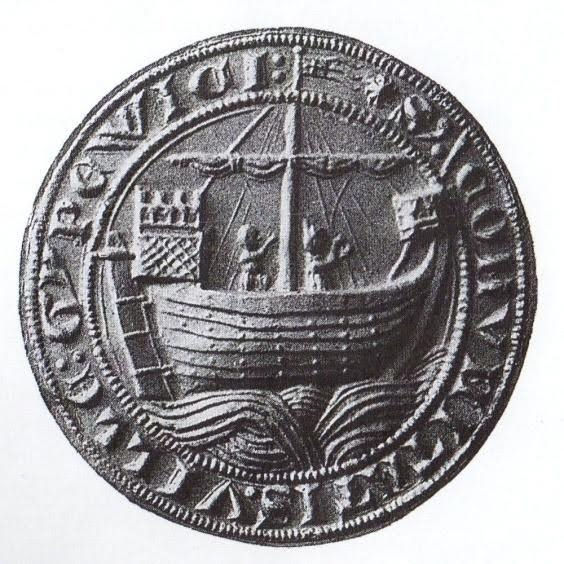
Several months after the granting of Ipswich’s charter in May 1200, the town’s newly formed government designed a town seal (see picture, left). Depicted on it is a Man o’ War vessel with castles fore & aft; much different from the small coastal vessels that would have been in use by the Ipswich merchants of that time, & possibly an early representation of the collier ships that would, in future centuries, become known as ‘Ipswich Catts’ (see Ships Named Ipswich page). But what is most interesting about the design, is that it is the first known example anywhere in the world of a ship with a movable rudder, as opposed to a steering oar commonly in use during that era.
The reverse of the seal depicts the church of St Mildred on the Cornhill, which would eventually become the town’s court & Town Hall.
Ipswich Coat of Arms

The design of Ipswich’s Coat of Arms is based on the arms of the Cinque Ports of Kent & Sussex, which provided support for the Royal Navy in centuries past.
The shield shows a lion rampant on the left, with the sterns of three ships on the right. This is supported by two seahorses. Above the shield, an armoured helmet is topped by a lion holding a sailing ship.
Priories & Friaries
The Augustinian Order (also known as the Austin Canons or Black Canons), established two priories in Ipswich during the reign of Henry II (1154-1189); Holy Trinity & St. Peter & Paul.
Although there had been an earlier church called Holy Trinity mentioned in the Domesday Book of 1086, Holy Trinity Priory, located on the site of what is now Christchurch Mansion, was built in 1177. In 1536 it was seized by the Crown and the priory was suppressed the following year. The site was purchased in 1545 by Paul Withipoll, a London merchant, whose son Sir Edmund commenced building the Mansion in 1548.
The Priory of St. Peter & Paul was located on modern day College Street, near St. Peter’s church. In late 1296 & early 1297 King Edward I stayed at the priory for the wedding of his daughter Elizabeth. In 1528 Cardinal Wolsey obtained papal permission to suppress the priory, and it became his shortlived Cardinal College of St. Mary. After his fall, in 1531 the property was sold to Thomas Alvard, a member of the King’s Household.
(See also Cardinal Thomas Wolsey & Christchurch Mansion & Park sections below)
During the latter half of the thirteenth century, the Dominicans, Franciscans & Carmelites all set up friaries in Ipswich.

The first to arrive were the Dominicans, or Blackfriars. Founded by Henry III, the order established themselves in Ipswich in 1263, their church & buildings being located in between modern day Foundation Street & Lower Orwell Street. The excavated remains of their buildings can still be seen today (See photo, left).
In 1278/9 the Carmelite or Whitefriars established their community in the area between the modern day Buttermarket & Falcon Street. King Henry VI was entertained here in 1452. Remains of their buildings were still in existence in the late nineteenth century. In 1987, during excavation works in the Buttermarket, the remains of the Carmelite church, chapter house & cloisters were discovered, although nothing is visible above ground today.
The Franciscan or Greyfriars, also known as the Friars Minor, established themselves in what is now Franciscan Way & Friars Street, close to St. Nicholas’ church, probably around 1280. Although nothing remains of their buildings, the area is still known as Greyfriars. (See also Ips Misc. page Ipswich Man - BBC Documentary)
As the three friaries were not particularly wealthy, they were not suppressed until 1538.
Our Lady of Grace
In 1297, the daughter of King Edward I, Princess Elizabeth, married John, Count of Holland in the Chapel of Our Lady near the Westgate in Ipswich. Also known as the Shrine of Our Lady of Grace, the chapel, built around 1152, housed a statue known as the Madonna of Ipswich. The statue was believed to perform miracles, & was a destination for pilgrims from at least the thirteenth, up until the sixteenth centuries.
Sir Thomas More, in 1515, witnessed a miracle in which a girl was supposedly cured of blasphemy at ‘Our Ladye of Ippeswitche’ (see The Maid of Ipswich, below). Other notable visitors were Catherine of Aragon in 1517 & Henry VIII in 1522.

When the Church of England broke with Rome, Henry VIII ordered the destruction of shrines like Our Lady of Ipswich. In July 1538 the statue was removed & taken to London, the intention being that it, & many others like it, were to be destroyed by burning. However it is possible that the statue survived & found its way to Nettuno on Italy’s west coast. One theory is that it was taken by English sailors who were shipwrecked there in 1550. Another is that, rather than being destroyed, it was sold. Whether the statue that stands in the Piazza Massino is the Ipswich Madonna, or how She came to be there, will probably never be known with certainty. However, the Nettuno statue is known as ‘The English Lady’ & the front part of her shoes are made of silver. It was recorded, when the statue was moved from Ipswich to London in 1538, that She possessed ‘half shoes of silver’.
It is not clear exactly when the Chapel of Our Lady was destroyed, but it would probably not have survived long after the Madonna’s removal. Today, a bronze statue & a plaque adorn the wall of Lady Lane, just off Westgate Street (see picture, above left). A replica of the Nettuno statue can also be found at the rededicated shrine in St. Mary Elms church in Elm Street.
The Maid of Ipswich
Anne Wentworth (c.1503-c.1572) was the daughter of Sir Roger Wentworth of Gosfield, Essex, who was twice MP for Ipswich, and also a friend of Sir Thomas More. Around 1515, when Anne was twelve, she fell ill and suffered from seizures in which she blasphemed and began to have visions, all of which were believed to be the work of Satan. Then one of her visions convinced her that she must go on a pilgrimage to the Virgin at Our Lady of Ipswich (see above). She did so and went through various torments there. However, these torments supposedly drove out the devils that had possessed her and, in the presence of the whole company, she was suddenly restored. Anne was left with the gift of prophesy, and thereafter was sought after as “The Maid of Ipswich”. In grateful recognition of the miracle, she took the veil and became a nun. She entered the convent of Bruisyard in Suffolk and, after the dissolution of the monasteries, she lived in Framlingham.
The Ipswich Martyrs

Situated in Christchurch Park in central Ipswich is a memorial to the Nine Ipswich Martyrs. Erected in 1903, the stone monument commemorates nine Protestants burnt at the stake for their beliefs during the period 1538-1558. Seven of the nine people whose names are commemorated; N Peke (1538), ? Kerby (1546), Robert Samuel (1555), Agnes Potten (1556), Joan Trunchfield (1556), Alexander Gooch (1558) & Alice Driver (1558), were burnt on the Cornhill in Ipswich. The other two; John Tudson (1556) & William Pikes (1558), were Ipswich residents burnt in London & Brentford respectively.
With a base of Ketton stone & a shaft of polished red granite, the 27 ft high memorial was designed & created by the Art Memorial Company of West Norwood & was funded by private subscriptions, after a series of articles by Nina Frances Layard had appeared in the East Anglian Daily Times between 1898 & 1902, which brought the executions to public attention . These articles were republished in book form in 1902 as Seventeen Suffolk Martyrs.
Most of the executions occurred during the reign of Queen Mary I (1553-58), during which time she re-established Roman Catholicism, & is known to have had more than 280 Protestants put to death; earning her the sobriquet of “Bloody Mary” in the process.
Historic Churches
It has been said that no other town of comparable size in England has preserved as many of its medieval churches as Ipswich. The Norman Domesday Book of 1086 lists twelve churches in Ipswich (although the omission of others such as St Mildred’s, known to have been in existence on the Cornhill at that time; All Saints, which may have been situated in the modern day London Road/Handford Road area ; & Osterbolt, whose location was in the area of present day Shire Hall Yard/Foundation Street & which is possibly another name for one of the churches mentioned in Domesday that remain unidentified, all points to the fact that the list is incomplete). Five, or possibly six of the Domesday churches still exist to this day. These were all of Saxon origin & were probably all wooden structures at that time; the Normans rebuilding them in stone during the late eleventh or twelfth centuries. Those listed in Domesday that no longer exist are:
Holy Trinity, which was situated on the site of the present Christchurch Mansion in Christchurch Park, which ceased to be a parish church when it became part of the Priory of the Holy Trinity in 1177 (see Priories & Friaries section, above).
St Augustine’s, on the Stoke side of the river, which is known to have been in existence until the second half of the fifteenth century, but was probably demolished soon afterwards.
St George’s Chapel, which was just outside the Westgate in St George’s Street (also known as Globe Street), & is known to have been in existence, although derelict, until the early nineteenth century.
St Michael’s, the location of which is uncertain, although it is thought by some to have been on the site of St Nicholas Church.
St Julian’s, site unknown.
St Peter’s. There are two St Peter’s listed in Domesday, the one near Stoke Bridge (see below) & a second, location unknown.
Those listed in Domesday that are still in existence today are, St Lawrence, St Peter’s, St Stephen’s, a church on the Stoke side of the river in the holding of St Etheldreda, & two by the name of St Mary’s. If we assume that the church belonging to St Etheldreda, (& therefore the monastery at Ely) is St Mary at Stoke, then the two other St Marys are probably St Mary Le Tower & St Mary at the Elms.
St Mary Le Tower: As the name suggests, this was probably the first church in Ipswich to have a tower; an indication of the wealth of the parish. Situated in modern day Tower Street, it was in the churchyard of St Mary’s in June 1200 that the townspeople of Ipswich met to receive the borough’s first charter, which had been granted by King John on 25th May of that year, & to codify the by-laws. Most of the church in evidence today was rebuilt in during the period 1860 – 80, including the present tower which stands at a height of nearly 200 feet; the previous tower having fallen into ruin around 200 years before.
St Mary at the Elms: Often known simply as St Mary Elms, this church on Elm Street may have been built on the site of an older church called St Saviour’s. The church doorway is thought to date from as far back as the eleventh century, whilst some of the bricks intended for Wolsey’s Cardinal College of St Mary were used in the rebuilding of this church after the Cardinal’s fall from favour in 1529. The church today contains the rededicated Shrine of Our Lady of Grace (see Our Lady of Grace section, above). The row of cottages behind this church are thought to be the oldest buildings in Ipswich, whilst situated at the front of the church is a modern bronze statue of a girl sitting cross-legged handling a ball of clay. Named ‘Tam’, the sculpture was created by Honoria Surie.
St Lawrence: Accessed by the pedestrian Dial Lane & St Lawrence Street, which both connect Tavern Street with the Buttermarket, St Lawrence’s main claim to fame is its bells, which are the oldest surviving set of church bells in the world (see St Lawrence - The World’s Oldest Church Bells section, below). The church was rebuilt around 1440, although the extant tower dates from 1882. Prior to this, the clock on the old tower had protruded at an odd angle into what had been known since medieval times as Cook’s Row. From the middle of the nineteenth century, however, it became known as Dial Lane. The building is no longer used as a place of worship, but is in the care of the Ipswich Historic Churches Trust &, as the St Lawrence Centre, is run as a café & bistro, as well as being available for private hire.
St Peter’s: Located by Stoke Bridge, St Peter’s is probably the site of the first church in Ipswich, as this area was the hub of the original settlement by the river. Now known as St Peter’s by the Waterfront, the church stands between College Street & Star Lane, although originally the river ran much closer to the church than it does today. In 1130 the Augustinian Priory of St Peter & St Paul was established just to the north of the church, with the present church dating from the fifteenth century. The Priory was dissolved in 1526 to make way for Wolsey’s Cardinal College of St. Mary, & the church became the college chapel; although after the Cardinal’s fall from favour, St Peter’s reverted to a parish church in 1537. St Peter’s by the Waterfront is today a heritage centre & concert venue, & is the permanent home of the Ipswich Charter Hangings (see separate section, below).
St Stephen’s: Originally standing in St Stephen’s Lane, the development of the Buttermarket Shopping Centre & the widening of the lane means that the Domesday listed St Stephen’s Church now stands in Arras Square. The building seen today dates from the fifteenth century, but ceased to be used as a church in 1975. The church is now the town’s Tourist Information Centre. Inside, the church features a memorial to Robert Leman, one time Mayor of London, who died in 1637.
St Mary at Stoke: Situated in a prominent position on the south side of the river, the Grade I listed St Mary at Stoke stands at the junction of Stoke Street & Belstead Road. The medieval church belonged at the time of Domesday to the Monastery of Ely. St Mary at Stoke was extended & refurbished in the nineteenth century; the main benefactors to this work being the Burrell family who lived at Stoke Park Mansion (since demolished).
St Mary at the Quay: Situated to the east of St Peter’s, in an area now enclosed by Star Lane, Key Street & Foundation Street, St Mary at the Quay (also known as St Mary at Quay or simply St Mary Quay) is thought to have been in existence since the late eleventh century, although it is not thought to be one of the St Marys mentioned in the Domesday book & may have at one time been known as Stella Maris. Once part of the Priory of St Peter & St Paul, the present church was built in the mid fifteenth century. One of the church’s major benefactors was Ipswich merchant Henry Tooley, after whom Tooley’s Almshouses in Foundation Street are named, & whose tomb can still be seen in the church. No longer in regular use, St Mary at the Quay is now in the care of the Churches Conservation Trust.
St Clement’s: Situated to the east of St Mary at the Quay, & also on Star Lane, is St Clement’s Church. The parish was originally outside the town ramparts & is thought to have been established in the twelfth century; possibly on the site of an older church. It is known as the Sailor’s Church due to its proximity to the river, & is the burial place of Thomas Eldred & Sir Thomas Slade (see relevant sections below). It is no longer in use as a church.

St Margaret’s: St Margaret’s is a Grade I listed building situated in a commanding position at the junction of Soane Street, Bolton Lane & St Margaret’s Green, adjacent to Christchurch Park. It was built to replace the parish church of Holy Trinity, sometime after the latter became part of the Augustinian Priory in 1177. After the church was damaged by bombing during the Second World War, two leaded stained glass medallions, dating from the 17th century & featuring St Luke & St Mark, were presented to St Paul’s Church in Ipswich, Queensland (see St Paul’s Church - Link with Ipswich, England section on the Ipswich, Queensland page, & the Ipswich, Queensland album in the Photo Gallery).
St Matthew’s: Thought to have been built in the late eleventh century, most of the building seen today was designed in the nineteenth century in the English Gothic Revival Style by Sir George Gilbert Scott. St Matthew’s became known as the Garrison Church during the nineteenth century, as it was the closest church to the army barracks which stood from 1795 until 1929 in the Norwich Road/Anglesea Road/Berners Street area. The church is situated between Civic Drive & Portman Road.
St Helen’s: Situated on St Helen’s Street, this church has been in existence since Norman times & was originally outside the town walls. St Helen’s was largely rebuilt & restored from the 1830s onwards, with the tower being erected around 1875, although the porch is much older & thought to date from the fifteenth century. Being somewhat away from the main settlement, in medieval times two leper hospitals were situated in the general vicinity; St James & St Mary Magdalene. One of these is thought to have stood very close to St Helen’s church, although opinion is divided as to which one. The Leper Hospital of St Mary Magdalene is known to have been in existence since at least the year 1199.
St Nicholas: St Nicholas stands on Franciscan Way & was built in the fourteenth century on the site of a previous church. This may have been the Domesday mentioned St Michael’s, as in 1818, during restoration, workmen discovered a wall painting of St Michael fighting a dragon, with a carved Anglo-Saxon inscription. Another inscription, this one in Latin & thought to date from the early twelfth century, is a dedication to a church called All Saints. This panel of Caen stone may have originally come from the lost church of that name that is thought to have stood near Handford Road Bridge.
Thomas Wolsey, whose house was in nearby St Nicholas Street, was probably baptized here & would have attended St Nicholas as a boy. His parents are buried here. Today the church is owned by the Anglican Diocese of St Edmundsbury and Ipswich, & run as the St Nicholas Centre; a conference & events venue, which also includes The Sanctuary restaurant.
Unitarian Meeting House: Built in 1699 & opened the following year, this timber framed Grade I listed building is located in Friars Street, & is today overshadowed by the modern glass structure of the adjacent Willis Building. The Meeting House was built by English Presbyterians, but during the 18th century the congregation gradually moved to a Unitarian position. When legal restrictions were removed on calling themselves Unitarians (1813), & having possession of their own places of worship (1844 Dissenters’ Chapels Act), the Meeting House became known as Unitarian. The word Church, Chapel and Meeting House have over time been used to describe the building, although for many years it has been known as a Meeting House as in the original Trust Deed of 1711. It is one of the finest surviving examples of a purpose-built seventeenth century Nonconformist church in England. The interior includes many impressive original features, including an elaborately carved pulpit.
Just outside, between the Meeting House & the Willis Building, stands the Millennium Obelisk; the four faces of which celebrate: the Millennium, the 300th anniversary of the Unitarian Meeting House, the 25th anniversary of the Willis Building, & the 800th anniversary of the town’s first charter.
(Please note: All the churches listed above are Grade II listed buildings, unless otherwise stated)
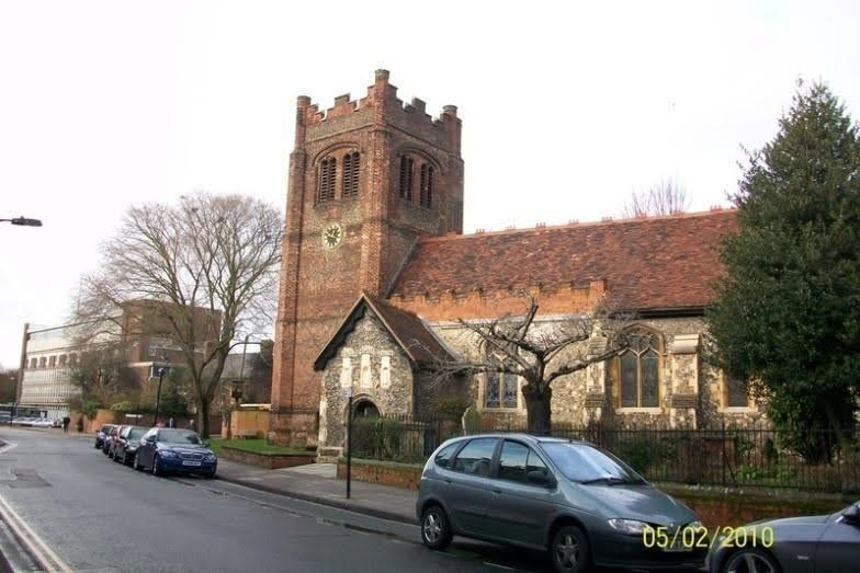
See the Churches: Ipswich, England album in the Photo Gallery for pictures of all the churches featured above.
St. Lawrence - The World's Oldest Church Bells
The set of five bells in St. Lawrence Church in Dial Lane, central Ipswich are the oldest surviving set of church bells in the world. Often called “Wolsey’s Bells”, four of them were cast around the year 1450, with the fifth being added around 1480. They have remained undamaged for over five hundred years & still retain their original clappers.
The tower in which they were housed was deemed unsafe in 1985 & the bells were removed while the tower was reconstructed & fortified. A new bell frame was also installed & the bells were returned to their rightful place in September 2009.
(See also Historic Churches section, above)
Cornhill

The Cornhill in the town centre has been the hub of Ipswich life since at least the Saxon era. In ancient times the Cornhill was a marketplace where the people of the region would come to buy & sell produce such as livestock, meat, fish, timber &, of course, corn. (Painting on left - View of the Cornhill by George Frost).
On the south west corner, on the site of the modern day Town Hall, once stood St. Mildred’s church. Probably built around the year 700 AD, it was named after the daughter of Merewalh, King of Mercia. As a girl, her mother sent her to live in a convent in France. Upon her return to Britain, she became abbess of Minster-in-Thanet in Kent. Said to have been very generous to the poor, her popularity spread & her tomb became a place of pilgrimage. The church survived until the fourteenth century, when it was converted to become Ipswich’s first Town or Moot Hall, which was also used as a court house. Outside stood the stocks & pillory, & in this area public hangings took place. It was also the place that heretics were burned during the sixteenth century, including nine protestant martyrs who were burnt at the stake during the period spanning the years 1538 to 1558; a memorial to whom now stands in Christchurch Park.
Although there may have been some sort of cross on the Cornhill since the time of Ipswich’s charter in 1200 AD, the first recorded Market Cross was erected in 1510; a gift to the town from Edmund Daundy, a relative of Cardinal Wolsey. This was replaced in 1629 by an octagonal shaped, open sided structure with a statue of Justice on top, complete with sword & scales (see picture, above). This structure was finally removed from the Cornhill in 1812.
On the south east side of the Cornhill, on the site of what is now the Old Post Office, stood a timber structure with an open ground floor area known as the Shambles. Built around the thirteenth century, this building housed the meat & fish markets & was also used for the slaughter of livestock. Nearby was situated a stake used for bull baiting; a practice that continued until 1676.
Sometime around 1792-1794, the Shambles was demolished & its place taken by the Rotunda; a circular market building with a domed roof & living accommodation for the market traders on the first floor, designed by George Gooding. This building, however, was poorly built & badly ventilated & stood only until around 1810, when it was condemned & pulled down.

In its place rose the first Corn Exchange, also designed by George Gooding. Above the entrance, the statue of Justice, taken from the now removed Market Cross, was re-erected; transformed into Ceres, the Roman goddess of agriculture, with her sword & scales being replaced by a sickle & a bundle of wheat ears. When first built this structure was roofless & open to the elements. It took until 1849 for a roof to be added, during a period of complete rebuilding. Thirty years later, however, the Corn Exchange moved to new premises in King Street, behind the present Town Hall, & once more this area of the Cornhill saw a period of demolition & rebuilding. Designed by Brightwen Binyon & opened in 1882, the imposing Post Office building still stands today, although it is now a bank. The statues above the entrance represent Industry, Electricity, Steam & Commerce (see photo, above).
The last remnants of what had formerly been St. Mildred’s church were finally pulled down in 1867, & the following year saw the opening of the Venetian style Town Hall. As with the Post Office, the Town Hall also has four statues above the entrance; in this case representing Commerce, Agriculture, Learning & Justice. The building housed the courts & police station, as well as the administrative offices of the corporation; an arrangement that continued until the 1960s, when the police, courts & council offices were moved to new premises in Civic Drive. The Mayor’s office, however, is still located here. Today the Town Hall also features an art gallery, whilst at the rear, the Corn Exchange is now a concert & entertainments venue.

Today, the oldest surviving buildings on the Cornhill are the timber framed Mannings pub & the Golden Lion, on the western side of the square; the latter having been in existence since at least the sixteenth century. On the north side of the Cornhill is the Lloyds building; built in 1890, it gives its name to Lloyds Avenue, which is reached by way of an archway that was cut through the building in 1929. Once open to motor traffic, the arch is now a pedestrian only thoroughfare.
In 2018, the Cornhill was given a £3.6m overhaul, with a totally new layout including fountains, new seating, and the “Four Gateways” sculpture (see photo, above.left).
The four concrete arches that made up the Four Gateways had metal plaques attached telling of four different aspects of the town; namely the town’s history, the waterfront, pioneering Ipswich residents and Ipswich Town FC. The Four Gateways, however, proved unpopular and was removed in September 2019.
With Lloyds Avenue leading away northwards, Princes Street running to the south, Westgate Street & Tavern Street dissecting it from east to west, & the pedestrian Thoroughfare & Lion Street at the south east & south west corners respectively, the Cornhill is still, as it has been for more than 1300 years, the hub around which Ipswich life revolves.
The market, too, still survives; being held on Tuesdays, Thursdays, Fridays & Saturdays, but has now been moved a short distance away into the top end of Princes Street and Giles Circus.
The Treadmill – An Ipswich Invention

The treadmill, as an instrument of prison discipline, was invented by William Cubitt, an inhabitant of Ipswich. William Cubitt (1785-1861) was born at Dilham in Norfolk, where his father was a miller. He was an eminent English civil engineer. In 1812 he entered into a contract with Ransome & Son, the principal ironfounding firm in Ipswich, to develop their general engineering business, and became their chief engineer. He designed and installed various iron bridges and supervised the first Ipswich gasworks. He worked on canals, docks, and railways, including the South Eastern Railway and the Great Northern Railway. He later moved to London and was the chief engineer of Crystal Palace erected at Hyde Park in 1851. He was president of the Institution of Civil Engineers between 1850 and 1851.
Noting stubborn and idle convicts at Bury St Edmunds gaol, he proposed using their muscle power both to cure their idleness and produce useful work. He invented the prison treadmill or treadwheel, installing the first one in Bury St Edmunds gaol in 1819, followed by Brixton in 1821, then at Worcester, Liverpool and elsewhere. The Brixton treadmill was particularly notorious (see illustration, left), and was commemorated in a 19th century ballad. Enthusiasm for this new device soon spread, and a treatise was soon forthcoming: “Description of the Treadmill Invented by Mr. William Cubitt of Ipswich for the Employment of Prisoners” published by the committee of The Society for the Improvement of Prison Discipline, &c (1822).
Treadmills as muscle powered engines originated roughly 4,000 years ago. Their primary use was to lift buckets of water. The main difference with Cubitt’s invention was that, whereas previously users would be inside the wheel where they could relax the rotation of the wheel, the users on his device were on the outside of the wheel which remained in constant motion, like walking up an endless staircase. He also designed it so that multiple users could be on the device. They were like twenty-foot long paddle wheels with twenty-four steps around a six-foot cylinder. Several prisoners stood side-by-side on a wheel, and had to work six or more hours a day. While the purpose was mainly punitive, it was also used to grind grain or lift water.
Prisons all over Britain and the United States bought the machines. In 1824, prison guard James Hardie credited the device with taming New York’s more defiant inmates. He wrote that it was the treadmill’s “monotonous steadiness, and not its severity, which constitutes its terror”. However, it gained notoriety as an instrument of torture. Over the years, American wardens gradually stopped using the treadmill in favour of other backbreaking tasks, such as breaking rocks. In Britain, the treadmill persisted until the late 19th century, when it was abandoned for being too cruel. Today individual treadmills can be purchased as exercise equipment, presumably appealing to those with more masochistic tendencies
The Ancient House
Standing on the corner of the Buttermarket & St. Stephen’s Lane, the Ancient house is a grade I listed building dating from the fifteenth century.

Built by Thomas Fastolf of Nacton, it was extended by George Copping, who built the ‘long gallery’; having acquired the house in 1567. In 1591 it was taken over by William Sparrowe, who turned it into a grocery & spice shop. The Sparrowe family owned the property for the next three hundred years, hence the building’s alternative name of ‘Sparrowe’s House’. It was the Sparrowe family that added the elaborate wood carving & extensive decorative pargeting (plasterwork) that can be seen today. Legend has it that King Charles II hid in the house after the Battle of Worcester in 1651; the Sparrowes being secret Royalists. However, this seems unlikely, as the King was Catholic & Ipswich at that time was staunchly Puritan. In 1801, however, a secret chapel was discovered in a concealed loft, in which were found wooden angels & other Catholic artifacts. The King did visit Ipswich in 1668, after the Restoration, & his Royal Arms can be seen in the pargeting. Also to be seen are the four known continents (Australasia having not been discovered at the time), the elements earth, air & water, & St.George slaying the dragon.

The interior boasts decoration dating from every century from the fifteenth to the twentieth, including elaborate wood carvings, plasterwork & fireplaces. During restoration work, two painted linen wall hangings were discovered depicting the Labours of Hercules; one shows Hercules slaying the Hydra (see left), the other his battle with the giant Antaeus. These 4 feet by 8 feet cloths can be dated to the sixteenth century, as they are mentioned in George Copping’s will of 1578. Replicas of these hangings now adorn the walls above the main staircase in the house, whilst the originals are housed in Christchurch Mansion.
Throughout most of the twentieth century, the Ancient house was a bookshop. It was acquired by Ipswich Borough Council in 1980 &, after much needed renovation work, is now a Lakeland shop, with a small art gallery also on site.
Pykenham's Gatehouse

Pykenham’s Gatehouse is a Grade I listed building located in Northgate Street, just opposite Ipswich Central Library. It was built around 1471 by William Pykenham, who had just been appointed Archdeacon of Suffolk at that time. Having decided that the house he had rented from the Priory of the Holy Trinity was not fitting for his status, he proceeded to have the gatehouse built on adjoining land. The front of the gatehouse consists of a large brick four-centred arch, whilst the back is timber-framed with wattle & daub filling between the studs. The room above the gateway was used as accommodation by the gatekeeper. Archdeacon Pykenham later had the Deanery Gateway built in nearby Hadleigh. He died in 1497.
Today Pykenham’s Gatehouse is owned by the Ipswich & Suffolk club, whose premises are situated behind the gateway. It is leased by them to the Ipswich Building Preservation Trust, who use it as their headquarters. In 1983 the Trust carried out extensive restoration work on the building.
Tooley's & Smart's Almshouses
Located in Foundation Street, close to the ruins of Blackfriar’s church, are Tooley’s & Smart’s Almshouses. Originally established in 1550, they were originally known as Tooley’s Almshouses & took the name from Henry Tooley (or Toolie), who left money in his will of November 1550 for the building & upkeep of almshouses for 10 townsmen who “shall be tried unfaynedlye lame, by occasion of the kynges warres”. In other words, soldiers injured in action.

Henry Tooley (or “Great Tooley” as he became known), was an elected portman & well known merchant in the town, who established trading links with France & Spain; importing wine & salt, & exporting Suffolk cloth. He is known to have rented a house & cellars in Bordeaux, & often made twice yearly excursions there. He also sent his ship, the Mary Walsingham, to Iceland on at least one trading mission.
Tooley’s date of birth is unknown, although it is thought he was born in Norfolk. He is first recorded as a householder in Key (or Quay) Street in Ipswich in 1499, when he was probably in his 20s. Around this time he married Alice Purpet, & they had three children, although none survived to adulthood. Henry Tooley’s tomb can still be seen today inside St Mary at the Quay church.

When local draper & portman William Smart died in 1598, he bequeathed several estates in his will to the poor. It was decided that a portion of the existing almshouses in Foundation Street were to be used for the recipients of this charity, & thereafter the Tooley & Smart foundations joined together. A painted memorial to Smart can be seen in St Mary Le Tower church, which depicts a panoramic view of Ipswich as it would have been in the late sixteenth century. His name is also commemorated in Smart Street, which leads off Foundation Street by the side of the almshouses.
In 1846 the old almshouses were demolished, & the Grade II listed buildings standing today date from this time (see photo, above).
Another benefactor was Nathaniel Catchpole, alderman of the Borough of Ipswich & justice of the peace for Suffolk, who left a gift of money to the almshouses in 1902. Like Tooley & Smart before him, he is commemorated in stone on the walls of the buildings
Ipswich School
The forerunner of what would become Ipswich School, at that time known as The Grammar School, is known to have been in existence before the year 1400; probably founded by the existing priories of Holy Trinity & St Peter & Paul, together with the local Merchant’s Guild. The site of the original school is unknown, although one possibility is St Mary Le Tower church. In 1483, however, former town bailiff Richard Felaw bequeathed his house near to the Blackfriars in Foundation Street (then known as St Edmund Pountney Lane) to the school, as well as providing funds for the education of boys of poor parents. (Felaw’s name lives on in Felaw Street, & Felaw Maltings off Wherstead Road; now an office complex).
Thomas Wolsey (see below) who had been a pupil, incorporated the school (to be called The King’s School) into the plans for his Cardinal College of St Mary, which opened in 1528. When Wolsey fell from favour, however, the buildings were seized by Henry VIII, & it was one of his chief ministers, Thomas Cromwell, 1st Earl of Essex (1485 1540), who persuaded the king to re-endow the school. The school’s charter was confirmed in 1566 by Queen Elizabeth I, whose arms & motto Semper Eadem (Always the Same) have also been adopted by the school.
The school remained in Foundation Street, having taken over parts of the former Blackfriars, until 1842, when it moved temporarily to Lower Brook Street whilst new premises were sought. In 1852, Ipswich School relocated to its present site on Henley Road, close to Christchurch Park; the foundation stone for the new building being laid by Queen Victoria’s husband Prince Albert in July 1851.
The school became independent after the Second World War, having previously been closely connected with the Borough. In 1977 girls were admitted for the first time & the school is now fully co-educational. The school has now moved away from the previous boarding school tradition, & today the majority of the students are day pupils.
As well as Thomas Wolsey, other notable Old Ipswichians include author Sir Henry Rider Haggard (1856 -1925), pioneering neuro-physiologist and Nobel Prizewinner Sir Charles Scott Sherrington (1857 -1952), & artist, designer & President of the Royal Academy Sir Edward John Poynter (1836 -1919).Established in April 1873, Ipswich High School for Girls is an independent school that originally operated from The Assembly Rooms in Northgate Street. Having moved to a large house in Westerfield Road in 1905, the school relocated in 1992 to its present location; the Grade I listed Woolverstone Hall, set in 80 acres of parkland on the banks of the River Orwell just outside Ipswich. Notable former pupils include children’s author Enid Blyton (see below) & Eastenders actress June Brown (Dot Branning).
The Master's House (Samuel Ward/William King)
The Master’s House, situated at 19 Lower Brook Street, is so called because it was once the dwelling place of the Master of Ipswich Grammar School. Built in the 1590s, it was originally known as the Preacher’s House, as it was built for Dr John Burges, who was town preacher or lecturer at the time; a post that had been established by the Town Corporation during the reign of Queen Elizabeth I (1556-1603). It was also later the home of another more famous town preacher named Samuel Ward (1577–1640).

Puritan preacher Samuel Ward was born in Haverhill, Suffolk & moved to Ipswich in 1605, having previously attended St. John’s & Sidney Sussex Colleges in Cambridge. Aside from a brief spell in Holland in the late 1630s, he would remain the town lecturer of Ipswich until his death; preaching from the pulpit of St Mary-le-Tower Church. During this period, Ipswich was a staunchly Puritan town, & although popular with the local people, the outspoken Ward was often in trouble with both the Church & the Crown. In 1621, he spent a short spell in prison for producing an anti-Catholic/anti-Spanish engraving entitled Double Deliverance, with caricatures of both the Pope & the King of Spain. These were seen as an insult by the Spanish ambassador in London, at a time when King James I was attempting to negotiate the marriage of his son Charles to the Spanish Infanta Maria. In the following year, Samuel Harsnet, the Bishop of Norwich, began proceedings against Ward for non-conformity, although he was subsequently released from prosecution. He was sent to prison again in 1635, however, having fallen foul of the Archbishop of Canterbury William Laud’s attempts to impose conformity on the Church.
Samuel Ward died in March 1640 & was buried in St Mary-le-Tower Church in Ipswich.
One of Ward’s brothers, John, was rector at St Clement’s Church in Ipswich. Another brother, Nathaniel Ward (See Ipswich, Massachusetts Page), emigrated to America, where he is regarded as the ‘Father of the First American Constitution’.
After the house was acquired by Ipswich School, it was the birthplace of William King (1786-1865), whose father, the Rev. John King, was master of the school at that time. King became a physician before moving to Brighton, where, in the late 1820s, he founded a Co-operative Benefit Fund, whilst also writing & publishing a periodical called The Co-operator. Although the latter was only produced for two years (1828-30), it is now seen as the inspiration for the Co-operative movement in Britain; with the Rochdale Society of Equitable Pioneers, established in 1844, being seen as the first successful co-operative enterprise. A blue plaque commemorating King now adorns the walls of the house.
The Ipswich Institute

What would become the Ipswich Institute was founded in 1824 as the Ipswich Mechanics’ Institute. The seeds of its establishment were planted in the winter of 1823/4 by John Raw, who ran a bookshop & library in The Buttermarket, whose suggestion it was to form an organization run along the lines of Dr. George Birkbeck’s Mechanics’ Institution in London & Glasgow. In an age when there was little at no education for working people, the aim of the Ipswich Mechanic’s Institute was to provide lectures on instruction in the arts, sciences & other ‘useful knowledge’.
Initially based in St Matthew’s Church Lane, the Ipswich Mechanic’s Institute soon moved to The Buttermarket. Its first president was John FitzGerald, father of the poet Edward (see Edward FitzGerald section on the Suffolk, England page of www.planetsuffolk.com). Other early supporters were Robert Ransome & Richard Dykes Alexander. In 1834 the Institute acquired new premises on the site of a former chemist’s shop at 15 Tavern Street. Later, in 1849, adjoining premises were bought in Tower Street, where a lecture hall was built. In 1893 the word ‘Mechanics’ was dropped, at which time it became known simply as the Ipswich Institute.
During the period 1909-40, the lecture hall in Tower Street was leased to Poole’s Picture Palace, & after the Second World War became the Ipswich Arts Theatre. It is now the Old Rep public house.
The Ipswich Institute is still going strong today, with the Tavern Street site still serving as the Institute’s library & reading room. In 2001 the Institute acquired the nearby listed building known as The Admiral’s House in Tower Street. Once home to Admiral Benjamin Page, & visited by the Duke of Wellington, it is now used as an art centre & study rooms, whilst also housing the Institute’s restaurant & coffee lounge.
With the exception of Birkbeck College in London, the Ipswich Institute is the only surviving Birkbeck foundation, & still operates as an independent subscription library and educational charity; providing an extensive programme of leisure learning courses, talks & other activities. Of all the UK’s independent libraries, Ipswich Institute has the largest membership outside London, with around 2,500 members.
In 2009, the Institute founded the New Angle Prize for Literature. This biennial £2,000 prize is awarded to a book set in or influenced by the East Anglia region.
The Old Custom House

The Grade II listed building on Ipswich waterfront now known as the Old Custom House was opened in 1845, & replaced an even older timber framed custom house on the Common Quay, which had numerous pillars running along the front that formed a colonnaded walkway known as ‘Mariner’s Walk’. Dating from the sixteenth century, this building was described by GR Clarke in 1830 as “a low, ill-shaped, isolated building”, & by the time of its demolition in 1843 it was in a dilapidated, run down condition.
The new building was designed by John Medland Clark. It was constructed from red & cream bricks & features two stairways leading up to a first floor entrance surrounded by a four-columned portico facing the waterfront, with the Ipswich Coat of Arms above. The rear of the building features a clock tower.
The building was originally known as the New Hall of Commerce, & as well as the customs & excise offices, featured warehouses, a coffee house, & rooms where the merchants could carry out their business transactions. It is now the headquarters of the Ipswich Port Authority; the successor to Ipswich Dock Commission. The building has been restored in recent years & now boasts a conference centre on the ground floor.
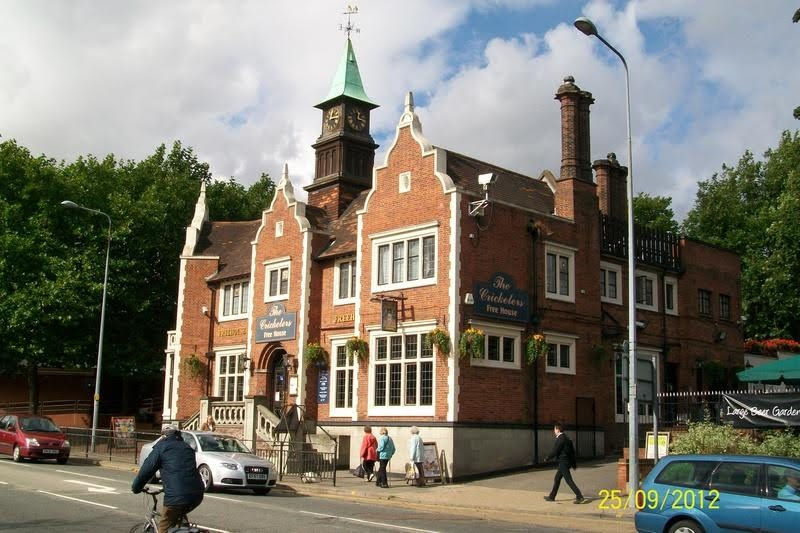
“Tolly Follies”

During the late 1920s & 1930s, Tollymache Brewery built a series of public houses in Ipswich that would become known as “Tolly Follies”. Mainly built on housing estates away from the town centre, the architecture of these ornate mock-baronial buildings is loosely based on the fifteenth century moated Helmingham Hall (see North & Central Suffolk section on the Suffolk, England page of www.planetsuffolk.com); the Tollemache family’s home located around ten miles to the north of Ipswich. None of the Ipswich pubs are completely identical, & some bear more resemblance to Helmingham than others. They are all spacious buildings with Tudor style chimneys, & many have their own clock towers.
Sadly, two “Tolly Follies” have since been demolished. The Safe Harbour, which stood on the corner of Highfield & Meredith Roads on the Whitton estate, closed for business in 1995 & was demolished two years later. A supermarket now stands on the site. The Waveney, at the junction of Bramford Road & Adair Road is also no more; having closed in 1995, it became a private members club named Churchill’s until 2004, when it too was demolished to make way for flats to be built on the site.
Of the surviving buildings, the fate of at least one is unclear. This is the Haven Hotel, which was built in 1928 on the corner of Felixstowe Road & Ransome Road. It was renamed the Crown in 2009, but currently stands unused after closing in late 2011.
The other surviving “Tolly Follies” are:-
The Cricketers in Crown Street (the only one in the town centre)
The Golf Hotel on Foxhall Road
The Golden Hind on the corner of Nacton Road & Maryon Road
The Suffolk Punch at the junction of Norwich Road & Cromer Road
The Margaret Catchpole on Cliff Lane
The Royal George at the junction of Colchester Road & Sidegate Lane
There are only two “Tolly Follies” built outside Ipswich, both in Cambridge. The Golden Hind on Milton Road, an almost identical building to its namesake in Ipswich; & The Cow (formerly The Red Cow) on Corn Exchange Street. They were built after the Tollemache Brewery took over Cambridge’s Star Brewery in the 1930s.
The title Baron Tollemache was created in 1876 for John Tollemache, who had been a member of parliament in Cheshire. The Tollemache family began brewing in Ipswich in 1888, when three of Lord Tollemache’s sons took over the Upper Brook Street brewery, which had been set up by Charles Cullingham in 1856. Tollemache Ipswich Brewery Ltd began to acquire public houses, both in Ipswich & further afield, as well as expanding the business with such acquisitions as Collier Brothers of Walthamstow in 1920 & Star Brewery of Cambridge in 1934. In 1957 the brewery merged with another local family brewing firm, Cobbold & Co, to form Tolly Cobbold, at which time the Upper Brook Street brewery closed. Tolly Cobbold finally ceased trading in 2002 (see also The Cobbold Family, below).

The Willis Building

Originally the headquarters for insurance company Willis Faber & Dumas, the Willis Building, as it is commonly known, was designed by architect Sir Norman Foster & built between 1970 & 1975. Officially opened by former Prime Minister Sir Harold Macmillan, the outside of the building is constructed from 890 sheets of toughened, half inch thick, darkly tinted glass, with a further 180 panes around the roof top restaurant. Also on the rooftop is a garden, complete with lawn & hedges, from which stunning 360 degree views of the town are possible. The building is in the shape of a grand piano, although to appreciate this fully you need to see it from above.
In 1991, the Willis Building became the youngest building in Britain to be granted Grade I listed status. It is currently owned by Willis Group Holdings.

In 1987, the Willis Building was featured on a Royal Mail postage stamp as part of the ‘British Architects in Europe’ series.
Ipswich Museum
Ipswich Museum was originally established in 1847 at newly built premises in the equally new Museum Street. Designed by architect Christopher Fleury, one of the early promoters was Charles Darwin’s tutor at Cambridge, Reverend Professor J S Henslow.
John Stevens Henslow was a clergyman, botanist and geologist, who became rector at Hitcham, Suffolk in 1839. In 1831, Henslow had been offered a place as naturalist on board HMS Beagle. Although he declined the offer himself, it was he who recommended Darwin to Captain Robert FitzRoy. A species native to North America, Henslow’s Sparrow Ammodramus henslowii, is named after him. He was elected President of Ipswich Museum in 1850.
In 1851 Queen Victoria’s husband, Prince Albert, visited the museum & is said to have been very impressed; speaking of very little else for several days, as the Queen is reputed to have remarked. The aim of the museum had always been to benefit & help educate the working classes & once Ipswich Corporation had taken over its management in 1853, the museum was open free of charge four days a week. In 1878, however, it was decided that bigger premises were needed & the present site was acquired in High Street. Opened in 1881, the new complex was designed by Horace Chesterton & included an art gallery & the School of Art. The original building in Museum Street is now occupied by ‘Arlingtons’ restaurant.
Today the museum is open from Tuesday to Saturday & entrance is free.
Taking pride of place as you enter, is a life size replica of a Woolly mammoth. Thought to be 210,000 years old, the remains of at least two woolly mammoths were discovered when Stoke High School in Maidenhall Approach was being built in 1975. Some of the bones are also on display in the Museum.
Other highlights include the Indian rhinoceros, giraffe & gorillas in the natural history gallery, as well as the Egyptian gallery, gallery of British birds & many other artifacts & exhibits from all around the world. The Ipswich Story, on the first floor gallery, tracks the history of Ipswich & Suffolk from prehistoric times up until the present day.

Ipswich Transport Museum
Ipswich Transport Museum is located on the eastern outskirts of Ipswich in the former Priory Heath Trolleybus Depot on Cobham Road (just off Felixstowe Road). The museum was established in 1988 & exhibits include horse drawn carriages, trams, trolleybuses, buses, coaches, lorries, fire engines, a police car & an ambulance; all of which were either made in Ipswich or operated in the area. The museum is also home to the Ipswich Engineering Collection, which includes such items as cranes, fork lift trucks & lawn mowers manufactured by local companies such as Reavells, Ransomes Sims & Jeffries and Ransomes & Rapier. The museum opens on Sundays, bank holidays & school holidays from April to November. There is a charge for admission.
Clifford Road Air Raid Shelter Museum
Situated at Clifford Road Primary School just off Foxhall Road, Clifford Road Air Raid Shelter Museum is housed in a World War II shelter beneath the school playground. Built during the first three months of the war, it was sealed up after the cessation of hostilities & largely forgotten about until its rediscovery in 1989, when workmen excavating a pond came upon one of the original entrances. Originally there had been thirteen sections of tunnel, each with its own stairway from the playground.
One section of the tunnel has been retained as closely as possible to how it would have looked during the war. Other exhibits include features on school life during the war, air raid precautions, a shop display showing items from the 1930s & 1940s, & rationing. Also on display is a section of a restored London Underground carriage dating from 1938.
The museum is open on selected weekends from April to October.
Christchurch Mansion & Park
Set within the 70 acre Christchurch Park, the mansion is a grade I listed building that stands on the site of the Priory of the Holy Trinity. The Augustinian priory, built in the twelfth century, was suppressed in 1537 and the lands were sold to the London merchant Paul Withipoll in 1545, whose son, Sir Edmund Withipoll, built the mansion in 1548-50. In 1649 the estate was inherited by the Devereux family.
In 1735, the estate was sold to the Fonnereau family, who occupied the house until 1894, when their intention had been to sell the mansion & land for demolition & development (see Fonnereau under Ipswich Garden Suburb in Housing Estates, Neighbourhoods, Suburbs, below). Fortunately, local businessman Felix Cobbold stepped in, bought the mansion & presented it to the town corporation, on condition that they purchased the surrounding park.
In 1904, a bronze statue of Queen Victoria was unveiled in front of the mansion. This only survived until 1942 however, when it was decided that the metal was of more use for the war effort.

Today Christchurch Park includes ponds, a wildlife area & the Upper & Lower Arboretums. Christchurch Mansion is a museum & art gallery, with a number of paintings by local artists Thomas Gainsborough & John Constable. Events & concerts are staged in the park each year, including the annual ‘Music in the Park’ festival in the summer & a firework display on the nearest Saturday to Guy Fawkes night.
If you look closely at a picture of Christchurch Mansion, then look at a picture of Castle Hill in Ipswich, Massachusetts, you will note some striking similarities. In 1919, when Richard Teller Crane Jr was looking for somewhere to expand the Crane Co of Chicago into the UK, he chose the town with the same name as that in which he had built his home; Ipswich, Massachusetts. How much the design of the second Castle Hill mansion (built in the 1920's) is based on the English house, & how much is mere coincidence, is not known. (See Ipswich, Massachusetts page & Ipswich, Massachusetts album in the Photo Gallery for comparison). The Crane name is still represented in Ipswich today by Crane Fluid Systems Ltd.
(See also The Ipswich Martyrs section, above)
Holywells Mansion & Park

Built in 1814 by John Cobbold, & the home of the Cobbold family for much of the nineteenth century, Holywells Mansion was presented to the town by Arthur Churchman in the late 1920’s. The 67 acre Holywells Park was opened to the public in 1936, but the mansion fell into ruin & it was demolished in 1962. All that remains are the stables, clock tower & orangery, which are now Grade II listed buildings. As the name suggests, the park is on the site of a natural spring & is reputed to have been the site of a manor owned by Edward the Confessor’s wife, Queen Edith.
Chantry Mansion & Park

Originally built in 1688 by Edmund Ventris, Chantry Mansion had several owners & underwent much alteration before being bought by Arthur Churchman in 1927 &, like Holywells Mansion, was presented to the town. The 126 acre Chantry Park, between London Road & Hadleigh Road, was opened to the public in 1928. It is Ipswich’s largest park. The mansion is a Grade II listed building & now operates as a Sue Ryder Care Home.
Situated at the Hadleigh Road entrance to the park is Chantry Park Gate Lodge. This Grade II listed building was probably built in the 1850’s by Sir Fitzroy Kelly, the mansion’s owner at the time.
Also within the park is a signposted walk known as the Sri Chinmoy Peace Mile. This is named after the Indian spiritual master Sri Chinmoy (1931-2007), who was also a prolific author, artist, poet, athlete & musician. He visited Ipswich twice in the 1980s & 1990s. His statue, sculpted by Kaivalya Torpy, was unveiled in the park in July 2013. The statue was a gift from the Sri Chinmoy Oneness-Home Peace Run, an international event which seeks to promote peace & harmony throughout the world.
Belstead Brook Park
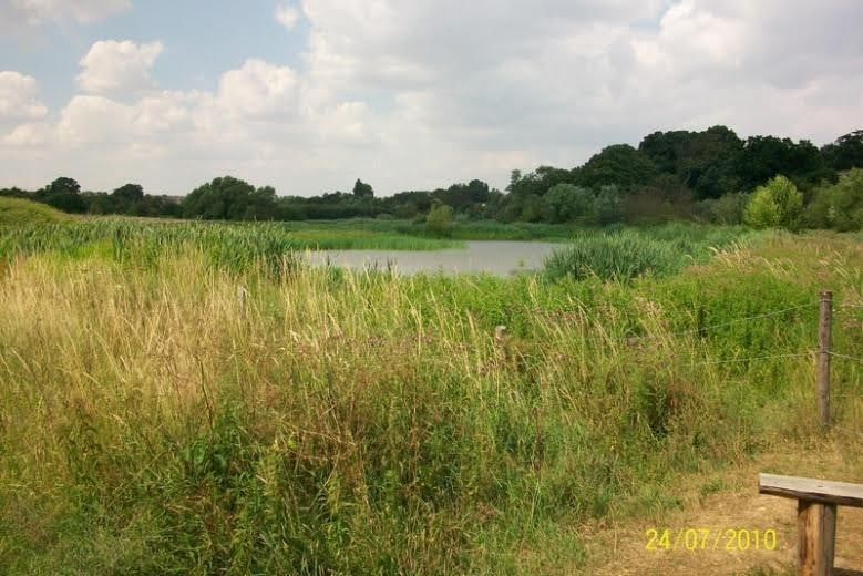
Established in 1991, Belstead Brook Park incorporates a connecting series of local nature reserves on the southwest outskirts of Ipswich, that stretch from Bourne Park in the east to the Copdock Interchange in the west, on the northern side of the A14. The park includes a number of diverse habitats such as reedbeds, water meadows, marshland, grassland & ancient woodland. The one constant feature of the various sections of the park is the shallow, meandering Belstead Brook, that rises near Hadleigh & flows into the River Orwell at Bourne Bridge. The park is managed by local volunteers, together with the Greenways Countryside Project. The park includes six Local Nature Reserves, as defined by the government’s environmental advisor Natural England.
Lying adjacent to, & on the south side of Bourne Park, is the Bourne Park Reedbeds Local Nature Reserve, which are thought to be the largest reedbeds in the south of Suffolk. The Belstead Brook flows through the reedbeds, close to its confluence with the River Orwell. Otters can be found along this stretch of the brook, & the reedbeds are home to a number of species of warblers & wildfowl. Between the reedbeds & the A137 road can be found the stretch of grassland known as Ostrich Meadow, & the privately owned Braky Woods. The origin of the name Ostrich Meadow derives from Sir Edward Coke (1552-1634) a barrister & Chief Justice to King James I, who was lord of the manor of Bourne Hall. His coat of arms shows an ostrich in the process of swallowing a horseshoe; symbolizing the Chief Justice’s capacity to digest legal problems, no matter how unpalatable. (The public house at Bourne Bridge was once called the Ostrich, but the name was changed in the early 1990s, when someone, misguidedly, assumed that Ostrich was a corruption of Oyster Reach, which is what the pub is now called).
Not actually part of Belstead Brook Park, but bordering it to the north is Bourne Park. This park, which stretches from Wherstead Road to Stoke Park Drive, was gifted to the people of Ipswich in 1927 by Alderman William F Paul, & was officially opened by HRH Prince Henry, son of King George V, in October of that year. At this time the trees for Corporation Avenue, which runs the length of the park, were planted. In recent years the Bourne Park Barn Owl Project has been established in the area adjacent to the reedbeds, to encourage this endangered species to breed here.
Opposite the Stoke Park Drive entrance to Bourne Park is the small Stoke Park Wood Local Nature Reserve. Now an area of woodland, scrub & wildflower grassland, it had originally been the location of Stoke Park Mansion. Although an earlier house had existed here, the last mansion was built in 1838 by Peter Burrell, a magistrate & High Steward of Ipswich, who became Lord Gwydyr in 1870. The mansion was demolished in the 1920s, & no trace of it now remains.
To the southwest of Bourne Park is Ashground Plantation; a wooded area with boardwalks, that follows the course of the brook through to the flood meadows of Bobbits Lane Meadows. The meadows & lake, home to a wide variety of birds including little egret & heron, are overlooked by a bird viewing screen & platform. Both Ashground Plantation & Bobbits Lane Meadows are part of Bobbits Lane Local Nature Reserve. It was in this area, when the nearby sewage works were being built in the 1950s, that the deposits which gave rise to the naming of the Ipswichian Interglacial Period were first discovered (see Ips Misc page).
Declared a nature reserve in 2012, the 11 acre Kiln Meadow Local Nature Reserve lies on the opposite side of the single track Bobbits Lane. It is predominantly shrub & wildflower grassland, as well as being home to one of the largest toad colonies in the UK, which migrate across the narrow lane to the Bobbits Lane Meadows in their thousands every spring.
To the south of Kiln Meadow is Spring Woods Local Nature Reserve. This is an ancient woodland, where coppicing is still practiced, as it has been for hundreds of years. (Coppicing is a form of woodland management, in which trees are cut back close to the ground to encourage new growth.) Nightingales can be heard here in the summer, & wildflowers include bluebells & wood anemones.
In contrast to the ancient Spring Woods, the neighbouring Millennium Woods Local Nature Reserve was, as the name suggests, planted by local volunteers in the year 2000. Approximately 5,000 trees were planted, with around a third of the site being left to regenerate naturally.

Across Stoke Park Drive from Bobbits Lane, the Belstead Brook winds through Ellenbrook Open Space, where areas of meadow & grassland are interspersed with sports & childrens’ playing facilities. The brook then flows under the road again, passing Ellenbrook Playing Fields & Quilter Drive Open Space, before meandering through Belstead Meadow; the westernmost section of Belstead Brook Park. Belstead Meadow is now a wildlife haven, with the grasslands being grazed by cattle during the summer months. In 1996, 8,000 trees were planted along the western boundary of the meadow, close to, & acting as a screen from, the main A14 road. Five years earlier, in 1991, the 90 trees that make up the Oak Avenue were planted to commemorate the 90th birthday of the Queen Mother. The avenue leads up to Belstead House (see photo, left), parts of which date back to the seventeenth century, although there are known to have been buildings on the site since at least the twelfth century. Once the the residence of visiting circuit judges, Belstead House is now run by Suffolk County Council as a residential conference & training centre.
Bixley Heath Local Nature Reserve
Straddling the boundary between Ipswich Borough & Suffolk Coastal District Councils, Bixley Heath is a 12 acre site that was declared a Local Nature Reserve in 1997. The reserve is located to the north of Bucklesham Road, just east of Ipswich Golf Club. The site consists mainly of heath & grassland, along with areas of woodland, scrub & reed beds, & is an important breeding site for birds in springtime.
The reserve is managed by Ipswich Borough Council & has been designated as a Site of Special Scientific Interest (SSSI).
The Dales Open Space Local Nature Reserve
Located on Dales Road in north west Ipswich, & surrounded by residential streets, the 14.5 acre Dales Open Space Local Nature Reserve is situated in a former sand & clay quarry which ceased operations in 1959. It was bought by Ipswich Borough Council in 1973.
The southern section of the reserve is steeply sloping, due to this area being one side of a now dry valley, whilst the terrain on the northern side of the site is much flatter.
Dales Open Space is characterised predominantly by woodland & scrub habitats. The reserve boasts varying plant communities, due to the two different soil types present here. There are also two spring-fed ponds which support a limited amount of aquatic flora.
Orwell Country Park

Straddling the boundary between the Borough of Ipswich & Suffolk Coastal District, Orwell Country Park is a 200 acre site along the north bank of the River Orwell to the southeast of Ipswich. Officially opened in 1995, it is part of the Suffolk Coast & Heaths Area of Outstanding Natural Beauty. The park includes a variety of habitats along the river estuary, such as ancient woodland, reedbed & heathland. From the shoreline, the park is dominated by the Orwell Bridge, & the park straddles both sides of the major A14 road. At low tide, the mudflats are an important feeding site for many species of waders & wildfowl.
Included within the park is the ancient Bridge Wood Local Nature Reserve, where many oak trees over 400 years old can be found, as well as sycamore, scots pine, elm & hazel. On the ground, bluebells, wood anemone & foxgloves abound, whilst wildlife includes foxes & deer. In summer, nightingales can be heard here. The name Bridge Wood is thought to derive from the idea that there was once an ancient river crossing point located here (see Myth of the Roman Road over the Orwell, below). To the north of the A14, is Braziers Wood, which also contains remnants of ancient woodland (to be defined as ancient woodland, there has to be evidence of continual woodland for at least 400 years).
The northern section of the park (the part within Ipswich Borough) is Piper’s Vale Local Nature Reserve, an area that was bought by the Borough Council in 1926. Known locally as “The Lairs”, this piece of rough recreational land on the shoreline includes heath, scrub & reedbed habitats. The area is a haven for birdlife,
with more than 100 species being recorded here, as well as several rare species of plant such as sulphur cinquefoil & meadow-rue.
The park also includes the Grade II listed Pond Hall Farm, which was once part of the thirteenth century Alnesbourne Priory.
Alderman Canal Local Nature Reserve

The area around Alderman Canal was declared a nature reserve in 1997. It comprises two Local Nature Reserves as defined by Natural England, the government’s advisor on the natural environment; Alderman Canal East & Alderman Canal West. The short canal joins the River Gipping at Handford Sluice (formerly Handford Lock) & then wends eastwards towards the junction of Handford Road & Alderman Road. The canal may have once been a tributary of the Gipping, but was converted into a canal with the construction of the Ipswich & Stowmarket Navigation in the late eighteenth century (see River Orwell & River Gipping section, below). As well as the canal, the 2.5 acre nature reserve also features reedbeds, hedgerows & grassland managed for wildflowers, which allows a wide variety of wildlife to flourish close to the heart of Ipswich. Wooden Walkways have recently been constructed through the reserve.
River Orwell & River Gipping
It is undoubtedly true to say that Ipswich is situated where it is because of the River Orwell. And it is also the case that the river, together with the town’s proximity to the North Sea & therefore the continent, was responsible for making Ipswich a major port, & probably the most important commercial centre in England, from the seventh century AD. As R A N Dixon remarked ‘‘Ipswich was a flourishing port when Liverpool was still a swamp and Hull an insignificant village’’.
The name Orwell is thought to derive from the Anglo-Saxon meaning ‘river near the shore’ although it is sometimes claimed that the ‘Or’ part of the name is Celtic or even pre-Celtic.

The Orwell empties into the sea at Harwich, where it is joined by the River Stour. Historically, the estuary close to Harwich was known as the ‘Port of Orwell’, or the ‘Salt Water’. Daniel Defoe noted in 1722 that although the name Orwell was in use, the more common name for the river was th9999ningtre-Water’ (see also Ipswich Water on The Ones That Got Away page).
During the late sixteenth century, with naval expansion caused by the threat from the Spanish Armada, Ipswich became a leading centre for ship building, due partly to the excellence of the local Suffolk timber. At this point Ipswich was being referred to as the “Shipyard of London”.
During the eighteenth century the Orwell became badly silted up, to the extent that only small vessels were able to reach the quays. From 1805 onwards, the task of deepening, widening & improving the river was undertaken & the New Cut was created to allow the flow of the river to by-pass the new Wet Dock, which was opened in 1842. Separating the dock from the New Cut was a 14 acre man-made spur of land known as the ‘Island’, which was originally laid out for public use with a tree lined promenade, seats, a bandstand/shelter known as the ‘umbrella’ & a statue of the winged horse Pegasus. Sadly the promenade, umbrella & statue were removed during the early twentieth century & the ‘Island’ is now an entirely industrial area.
Although they are in reality one river, in Ipswich the River Orwell becomes the River Gipping; this name being derived, as was Ipswich itself, from the name Gippeswick. However, at least until the fourteenth century, the whole length of the river, right to its source beyond Stowmarket, was known as the Orwell. When the change came about is not certain, but it is known that originally the name Gipping was given to a different stream; a short tributary that flowed through the marshes to join the Orwell just to the west of Stoke Bridge. Apart from a short spur on the waterfront, this river no longer exists.
Today, the Gipping rises from a small spring near Mendlesham, around 20 miles from Ipswich, flows close to the tiny village of Gipping, then down through Stowmarket to become the Orwell. Where the Gipping ends & the Orwell begins is open to debate. Some say it is at the Constantine Road weir, although this was only opened in 1903 (close to the new Sir Bobby Robson Footbridge). Others maintain that the name change occurs at the Horseshoe Sluice near London Road Bridge. The most common opinion is that the metamorphosis occurs where the river becomes tidal, or where the ‘salt water’ meets the ‘sweet water’.

Between 1790 & 1793 the Ipswich & Stowmarket Navigation was constructed on the Gipping. This consisted of 15 locks which allowed boats to traverse the 17 miles & 90 feet rise of the river between the two towns. With the coming of the railways, river trade dropped & the Navigation was finally closed in 1934. Much renovation has been done in recent years, however, & today a footpath called the ‘Gipping Way’ follows the towpath for most of the route.
For about five years, from 1929 onwards, the writer Eric Blair (1903-50) lived in the town of Southwold, on the Suffolk coast north of Ipswich. He is, of course, better known as George Orwell, whose most famous works include“1984” & “Animal Farm”. His pen name derives from the fact that he enjoyed many inspirational walks along the River Orwell.
(See also The Lost Port of Orwell)
The Shipyards of Ipswich
Taking into account the navigability of the river, it is unsurprising that shipbuilding would become a major industry on the Orwell; & as the largest town on the river, that Ipswich would become the hub of this activity. Although shipbuilding all but ceased during the early years of the twentieth century, during the sixteenth century, with naval expansion precipitated by the threat of invasion from Spain, the town’s importance as a ship building centre resulted in Ipswich being referred to as the “Shipyard of London”.
Probably the earliest representation of an Ipswich built vessel is the ship shown on the Town Seal (see above), which dates from the year 1200. Many other collier ships, or Ipswich Catts (see Ships Named Ipswich page) as they became known, would also have been built here, although very few records have survived relating to the exact location or date of their construction.
Although it is not known with any certainty, it is possible - indeed quite likely - that the Mayflower, the ship that took the English Puritans known as the Pilgrim Fathers to America, was built at one of the early shipyards at Ipswich before being taken to Harwich where she would have been fitted with sails & launched. The precise date of building is also unknown, although she appears in the Port Books of 1609-11, where she is designated as being ‘of Harwich’ (later records show her as being ‘of London’). Her captain, Christopher Jones, was born in Harwich around 1570, & many of the pilgrims who left England on the Mayflower in 1620 were from Suffolk. During the 1630s, many ships left Ipswich carrying settlers to the New World.
St Clement’s: It would seem that St Clement’s parish, on the eastern shore of the river, was probably the earliest location for shipbuilding in the town. Although records prior to the eighteenth century are scant, it is known that a ship which has become known as the Ipswich Galley (see Ships Named Ipswich page) was built in 1294 for the war with France, & one of the builders, Philip Harneys, is known to have had a shipyard in the area of today’s Neptune Quay in St Clement’s. Many of the vessels listed in the Ships with the suffix ‘of Ipswich’ section on the Ships Named Ipswich page would also more than likely have been built here. Pennington’s map of Ipswich, dating from 1778, shows three shipyards side by side in St Clement’s, situated at the bend where the river turns to the south (in the vicinity of today’s University Campus Suffolk building, near to the junction of Fore Street & Duke Street). Three other shipyards are known to have been built prior to the construction of the Wet Dock in 1840; the most southerly two, together with a ballast yard, being created on land reclaimed after 1808. Surviving registers of ships, lease agreements, rate book & tax returns provide evidence that ownership of these yards changed hands on a fairly regular basis. The leasing out of the yards by their owners to various shipbuilders was also a frequent occurrence, & very little is now known about many of these people or the vessels they built.
The best known shipbuilder in the parish during the eighteenth century was John Barnard (born c1705), who took over the shipyard from his widowed mother in 1734 (his father, also named John, having owned the yard from around 1710). Establishing himself in the second most northerly of the yards, Barnard launched the 24 gun sixth rate Biddeford, built for the Royal Navy in 1740. Around this time, the man responsible for designing Nelson’s flagship HMS Victory, Thomas Slade (see below) was employed by the Navy Board to oversee Barnard’s work. Barnard also built the fourth rate Hampshire for the navy in 1740/1, although due to her size, she was built downriver at John’s Ness (see below).
From around 1742, Barnard leased the navy yard at Harwich, where he concentrated most of his efforts thereafter. He did still build the occasional ship at his St Clement’s yard, however, where he also opened the town’s first public swimming bath in 1767. He was declared bankrupt in 1781, at which time, as well as shipyards in St Clement’s & Nova Scotia, he owned several farms in Essex & Suffolk & a large house in Duke Street, just behind the shipyards.

In 1818 Jabez Bayley, a member of the famous Ipswich shipbuilding family whose businesses had until now been concentrated on the other side of the river (see below), leased two shipyards in St Clement’s; seemingly in an effort to monopolise the shipbuilding industry in Ipswich. These yards were in need of repair, however, & Bayley soon found himself in financial difficulties, which culminated with him being declared bankrupt in 1825. He later resumed business here, & although most of the Bayley family’s ships were built at the St Peter’s, Nova Scotia & Halifax yards, some were launched from St Clement’s, such as the Indiaman Childe Harold of 400 tons. At the time of his bankruptcy, a relative of Jabez, William Bayley, took over the lease of two yards in St Clement’s & this business began to flourish during the 1830s.
With the gradual silting up of the river over the centuries, in the 1830s a proposal was made to create a new channel from a point just south of the St Clement’s yards around to the St Peter’s dock, in order to divert the river & create a new non tidal wet dock. A consequence of the New Cut, as this bypass channel came to be called, was that all six of the old yards in St Clement’s were now within the newly created Wet Dock. The last ship to be built in the old yards was the schooner Doctor, launched by Bayley in 1841. (One final vessel, a small iron steamer named Chevalier, was built on this part of the waterfront in what was by then the Wet Dock in 1851. She was built by Ransomes & May (see Ransomes section, below), but due to difficulties encountered in launching a large craft in such a confined space, this event proved to be a one-off & no further records exist of shipbuilding here).
The Wet Dock necessitated the owners of the old yards & their tenants relocating, in 1841, to reclaimed land to the south of the dock. This land belonged to John Chevallier Cobbold, who had purchased the foreshore down as far as his brewery at the Cliff in 1829. Three new shipyards were established here, the westernmost one being first worked by William Colchester, (this would later become known as Dock End Yard). The central yard of the three was occupied by William Bayley, whose old yard, like Colchester’s, had also been owned by John Cobbold. The first vessel known to have been built here was the cutter Eagle in 1841. On the other (eastern) side of William Bayley’s yard, John Cobbold himself briefly established his own shipyard in the 1850s, although after his death in 1860 this became incorporated into Bayley’s premises.
When the elder William Bayley died in 1857, his two sons, William & James took over the firm. The younger William continued the family business here until 1889; latterly building mainly barges, although some deep water craft were still built, such as the barquentine Lucy in 1879 & the brigantine Clementine in 1885. The last vessel built by William Bayley & Sons was the Inflexible in 1889.
The Dock End Yard passed through various hands after William Colchester retired, until it was acquired by R & W Paul Ltd in 1901. They built several barges for their own use, & carried on repairs here until the yard finally closed in the 1970s.
In 1865 a new yard had been opened in St Clement’s parish, further south than the other three & closer to the Cliff Brewery. Known as the Cliff Yard, the first builders here were John & Alfred Lambert. They remained here for around five years, after which the Bayley brothers briefly occupied the premises before it was taken over by William Curtis. When Curtis retired in 1885, the Cliff Yard was taken over by his nephew William Orvis, whose company continued to build here until Orvis’ death in 1909. In that year, the firm launched the last sailing barge ever built in Ipswich, the Ardwina. The last occupants of the Cliff Yard were a company called Dan Marine, who introduced steel shipbuilding to Ipswich; the first being the motor barge Eaglet in 1910. The company went into liquidation in 1913, & the Cliff Shipyard disappeared with the construction of Cliff Quay after the First World War.
Nova Scotia: It is unclear exactly when the shipyard that became known as Nova Scotia in the parish of St Mary at Stoke, was first established, although the sale of a shipyard is recorded in the area in 1713. The site, three quarters of a mile downriver from Stoke Bridge, is in the vicinity of today’s West Bank Terminal. The name Nova Scotia was given to the site soon after John Barnard, who already owned a shipyard on the other side of the river in St Clement’s (see above), bought the land in 1749. For a theory as to why this & the neighbouring Halifax yard were so named, see The Villages & Hamlets of the Liberties of Ipswich section, below. By this time Barnard was concentrating most of his activities in Harwich, & used the Nova Scotia yard to store timber & coal & was soon letting it out to others. Barnard’s son William, in partnership with William Dudson, did build several ships here in the early 1760s, the largest being the Speaker, a 702 ton East Indiaman launched in 1763.
After Dudman & the younger Barnard relocated to Deptford on the Thames in 1764, William & John Bayley (exact relationship unknown) hired part of the yard from Barnard Snr. This was the start of the Bayley family’s involvement in Ipswich shipbuilding, which would see them almost monopolise the industry during the nineteenth century. John Barnard was declared bankrupt in 1781 & in the following year the yard was purchased by Timothy Mangles.
William Bayley soon set up his own yard, & it seems he had left Ipswich by 1785. When John Bayley died in March of that year, the business was taken over by his widow Elizabeth. Their four sons all worked in the yard at various times, although it was the second son George, & the youngest Jabez, whose names would become well known as Ipswich shipbuilders.
It was during the period 1787-92 that the short-lived whaling industry thrived in Ipswich, & it was probably during this period that the Bayleys’ moved the main focus of their business to the St Peter’s shipyard. Although Mangles built several ships from Nova Scotia in the late 1780s & early 1790s, such as the Ferdinand in 1791, the yard’s days as a shipbuilding centre were numbered. The Bayley family may have continued to use the yard until the end of the century, but after this time there seems to have been little ship building here.
St Peter’s: One of the earliest records of a shipyard on the western bank of the Orwell dates from 1702, when Joseph Clarke was assessed for tax on a shipyard & house not far below Stoke Bridge, close to today’s Great Whip Street. Very little is known about activities here until the 1770s, when a man by the name of Pearl Betts is recorded as building several vessels here, such as the 140 ton brig Mary and Ann in 1777, & the Ark in the following year. During the early 1780s, the yard was occupied by Captain Timothy Mangles, who was involved in the town’s brief whaling industry (see Ipswich (whaler) 1786 section on the Ships Named Ipswich page), although by 1783 he had moved to the Nova Scotia yard, further down river (see above). Conversely, it seems that the Bayley family, who had been at Nova Scotia since 1764, moved their business to St Peter’s in the late 1780s, at the time that Mangles was using Nova Scotia as his centre of operations for the whaling ventures.
In 1812, George Bayley’s son, also named George, was apprenticed by his uncle Jabez, who encouraged his nephew to open his own business at the St Peter’s yard in 1821. At this time Jabez put the Halifax yard up for sale & continued his own business on the other side of the river in St Clement’s (see above). The younger George, with financial assistance from another uncle named John Ridley, continued to build ships in St Peter’s until 1831. These included the steamers Ipswich & Suffolk in 1825. In 1831, however, he leased the yard back to Jabez Bayley. When Jabez Bayley died in 1834, George leased the yard to Jabez’s former business partner William Read who, along with Enos Page, built here until 1838, at which time they moved to the Halifax yard. This move was necessitated by the commencement of the construction of the Wet Dock & the New Cut, which signalled the end of the old St Peter’s shipyards, as they were directly in the path of the New Cut.
This was not quite the conclusion to shipbuilding in St Peter’s parish, however, as in 1852, after giving up his business at the Halifax yard, William Read opened a new yard on the “Island”, within the tideless Wet Dock. When Read retired in 1866, this yard was taken over by his foreman Ebenezer Robertson who installed a patent slip, after which this yard became the most productive in Ipswich during the 1870s. Robertson gave up the yard in 1886, at which time shipbuilding finally came to an end in St Peter’s.
Halifax: The first record of a shipyard at Halifax, further down river than Nova Scotia & close to Bourne Bridge, dates from 1783. The yard may have been established by Stephen Teague, a shipbuilder formerly plying his trade at the nearby Nova Scotia yard. In 1797 Teague launched the 18 gun brig-sloop Cruizer of 384 tons from Halifax. The Cruizer design was so successful that she soon gave her name to a whole class of warships; 111 being ordered by the navy over the next 30 or so years, nine of which were built by Jabez Bayley.
Bayley, who was renowned for the attention he paid to ventilation & rot prevention, had begun to attract orders from the Royal Navy, & expanded his activities to the Halifax yard in 1805; having found the St Peter’s yard unable to cope with the increase in business, & the waters there too shallow for the launch of larger vessels. In the decade between 1804 & 1814 he built more the 30 ships for the navy, although it is not always known in which yard, St Peter’s or Halifax, many of these were built.
One vessel that can be placed with certainty as being launched from the Halifax yard, however, is the Transit; a narrow, barquentine rigged craft built to a revolutionary new design by Capt. Richard Hall Gower (1767 – 1833). Gower had already designed a similar vessel in 1800 (also named Transit & built at Chichester), that had proved extremely successful in tests, although he was always unable to persuade the Royal Navy to adopt his design. Part of Gower’s education had taken place at Ipswich School, & from 1816 onwards he lived in the town.
Jabez Bayley also built a host of vessels for the merchant service, including brigs, cutters, packets, schooners, sloops & smacks, as well as several Indiamen such as the 579 ton Harleston in 1811 & the Georgiana of 256 tons in 1816. Another Indiaman, the Orwell, launched from Halifax in August 1817, was at 1,337 tons, the largest vessel ever built in the town.
When Read & Page (see above) were forced to leave St Peter’s in 1838 due to the construction of the new Wet Dock, they moved into the Halifax yard. It was here that they built some of the first ever iron barges, such as the Ironsides in 1841 & the Gipping in the following year.
In 1850 the yard was acquired by Thomas Harvey. He & his two sons worked the yard, building two mortar vessels for the Royal Navy in 1856. The dissolution of the partnership in 1864 signalled the final closure of the Halifax shipyard.
Above Stoke Bridge: The only known instance of any vessels being launched above Stoke Bridge occurred around 1874, when George Mason & Co. built two barges from their shortlived yard situated off modern day Burrell Road. The narrowness of the river at this point made the launching of craft difficult here, & the company’s future vessels were built in the St Clement’s yard of William Colchester.
John’s Ness: Close to the eastern end of today’s Orwell Bridge lies John’s Ness (sometimes called King John’s Ness). This site was used only occasionally for the building of larger ships, due to the deeper water required for launching. William Hubbard, whose main business was in the St Clement’s yards, built the fifth rate Greyhound here for the Royal Navy in 1703, & John Barnard also launched at least two warships from this location during the eighteenth century; the Hampshire (1741) & the Champion (1779).
The Waterfront

The transformation of Ipswich Wet Dock from an area of warehouses, wharves & quays, to a vibrant, lively centre with marinas, restaurants, luxury dwellings & leisure facilities, began in 1999 with the completion of 69 apartments in the vicinity of Neptune Quay. What was once one of the largest wet docks in Europe has, during the first decade of the twenty first century, become the biggest single regeneration project in the east of England, with more than one billion pounds either having been spent, or earmarked for future development.
From this beginning on Neptune Quay, the development has spread along the northern side of the Wet Dock to include St Peter’s Quay, Albion Wharf, Common Quay, Wherry Quay & around to Orwell Quay. As well as many new cafes, bars & restaurants, the Waterfront boasts Ipswich’s only four star hotel (Salthouse Harbour), a dance studio (DanceEast), plus the University Campus Suffolk building, which was officially opened in 2009 (for further details see University Campus Suffolk section on the Suffolk, England page of www.planetsuffolk.com).
Although many old buildings have been demolished in the past few years, some still stand alongside, or have been incorporated into, the newer ones. These include The Old Custom House (see separate section, above), parts of the Salthouse Harbour Hotel, & the Isaac Lord complex. Known as Isaacs on the Quay, the latter features a number of bars, & hosts live music events & barbeques. Parts of this complex of buildings dates back to Tudor times, although for whom the property was built is not known. Isaac Lord acquired the house & adjoining warehouse (known as the saleroom), from the Cobbold family in 1900, & the Lord family occupied the premises until the 1980s. Both the house & saleroom are Grade I listed buildings.
One of the more unusual eateries on the Waterfront is Mariners, a floating restaurant which is permanently moored on Neptune Quay. The boat on which Mariners is located was built in Bruges, Belgium, & was launched as SS Argus in 1889. She was subsequently requisitioned by the Belgian navy in 1940, before being sunk by the Germans, who then raised & repaired her. In the 1950s she was fitted out as a Red Cross hospital ship, & was renamed Florence Nightingale, sailing under the Dutch flag. In the 1970s & 80s she operated as a party boat, before being brought to Ipswich & opened as the Italian restaurant Il Punto in 1990. She became a French brasserie in 1994, & subsequently underwent the name change to Mariners.
Operating from Orwell Quay, the aptly named vessel Orwell Lady (see photo, below) has, since 2001, run regular cruises along the River Orwell & down to Harwich Harbour between the months of April & September. Built at Twickenham, London in 1979, the Orwell Lady previously operated on the Thames & at Poole, Dorset, before being brought to Ipswich. She is also available for private charter.

Sailing cruises are also available on the Orwell during the summer months from several Thames sailing barges that operate from the quay. Common in the nineteenth century, Thames sailing barges are flat bottomed vessels, around 80 to 90 ft in length, & usually spritsail rigged on two masts. Most have large mainsail & foresail, with a topsail above.
The Orwell Bridge

Spanning the River Orwell just to the south of Ipswich is the 4,222 ft long Orwell Bridge, which carries the A14 road from Wherstead on the west bank to Gainsborough on the east. Designed by Frederick Gibberd Partners & funded by the Dept. of Transport, construction began in October 1979 & the bridge was opened in December 1982. The 623 ft main span of the bridge was, at the time of construction, the longest pre-stressed concrete span in existence. The bridge is used, on average, by over 60,000 vehicles per day.
(See also the header photo of this website)
The Lost Port of Orwell
Orwell Haven or the “portus de Orwell” is the estuary of the River Orwell, but there is a strong tradition that there was once a town of Orwell located here that belonged to Ipswich, but was swept away by erosion of the coast. Some historians consider this to be a myth, but written evidence is available of such a place, as noted below:
- Between 1229 and 1466 writs were directed towards the men of Orwell town (ville de Orwell), and since these appear in the same context as Ipswich and Harwich, it must have been recognised as a separate place.
- In 1173 Queen Eleanor and Prince Henry, in rebellion against King Henry II, landed their forces at Orwell.
- In 1326 Queen Isabella with Prince Edward and Roger Mortimer landed at Orwell in Suffolk in their successful attempt to overthrow King Edward II.
- In 1338 King Edward III sailed with his invasion force on France from the “port of Orwell”
. - In 1347 a ship from the “town of Orwell” is recorded.
- In 1408 an arrest was made at the “town of Orwell”.
- 1466 is the last record of a “ville de Orwell”.
It is clear that writers of the time had a place on shore or a harbour in mind, not a stretch of water. “Oruelle” is marked on maps of this period in this vicinity, but they are not accurate enough to locate precisely where it was.
Historians who claim that such a port is a myth maintain that it actually refers to Harwich which is sometimes recorded as “Harwell”, and that “Orwell” is just an earlier form of its name. Harwich is not mentioned in the Domesday Book so at that time if anyone lived there it must have been a very small settlement. It is known to have existed by 1177, and is first recorded by the name of Harwich (Herewyk ) in 1238. “Arewan” is the early Anglo-Saxon name for the River Orwell adopted from the Celtic Briton’s name meaning ‘the river’. It is recorded as this in the Anglo-Saxon Chronicle in 1016, and is spelt “Orewell” in 1216. It is a far older name than Harwich, but nobody can explain why “Orewell” should become “Herewyk” which means ‘army camp’. The fact that both names co-existed for another 200 years would indicate that they are different places. However, there is a connection between the two. Harwich is said to have grown in importance on the decay of a “town named Orwell” which is said to have been located about two or three miles east of the present shore, where there is now a shoal called West Rocks. It was on the south side of the Orwell Haven on a ridge of land jutting out from Essex. Harwich fishermen claimed that brickwork and mortar were still visible at low water, and in the late 19th century dredging brought up building stone.
At this early period there were no other port towns that could claim jurisdiction over the Orwell estuary other than Ipswich. Then in 1253 the Earl of Norfolk turned the hamlet of Harwich into a town, and started a weekly market. Medieval Harwich grew rapidly and in 1318 it was given a charter and had become a busy little port. When Harwich developed as a port in the 1270s it started to make claims to the mouth of the estuary, and began diverting ships to its own port to collect tolls. It then became necessary for Ipswich to protect its long-held rights over this same stretch of territory. In 1340 a commission concluded that the “port of Orwell” was within the jurisdiction of Ipswich, and in 1378 it decided that this extended to “the arm of the sea thereto running from a place called Polles on Andrew Sand in the deep sea”, and that it was the Ipswich bailiffs and burgesses that had the sole right to take the custom duties for goods coming into the port of Harwich.
Nevertheless, it is acknowledged that Harwich is in the County of Essex, so it needs to be seen how Ipswich could claim jurisdiction over the opposite shore. This would relate to the movement of the River Orwell at its estuary. The River Stour flowed into the River Orwell before the latter river reached the sea, and there is no doubt that the River Orwell did once flow into the sea much further north under Bull’s Cliff in Felixstowe, roughly where Felixstowe Pier is located. Since it was important for the people of Suffolk to secure the approach to Ipswich they had to hold both sides of the River Orwell. This is clear from the Domesday Book (1086) where “Langestuna” or “Langar” (today Landguard Point) was a manor held by Roger Bigot as part of his lands at Walton in Suffolk. At the time this manor would have been south of the River Orwell on a ridge (Langar is Anglo-Saxon for ‘long gore’ (a long strip of land) that was probably still attached to Essex, although separated by low-lying marshland. The question is when was the shoreline breached further south?
The argument against the existence of Orwell is that it is not recorded in Domesday and neither is there a record of a major inundation resulting from a breach that destroyed the town of Orwell, as there is with Dunwich on the coast further north. This could be because the breach occurred before Orwell really existed. It is known that there were gales and floods about the year 1100. The river may have changed direction then and burst through marshy land to the sea along its present course, although the new estuary would be very much narrower and shallower than it is now. No record survives because neither Orwell nor Harwich existed at that date. However, it appears that after the breach there was still a neck of land extending out from Essex that had not yet been washed away. There was also a headland that projected out east of today’s Landguard Point, known as Pollshead (see below). These two headlands provided shelter for a harbour protected from the east and northeast winds. The “port of Orwell” would then have developed. It would not have been a town in the sense of having churches and major structures, but an anchorage place and harbour. There would have undoubtedly been rudimentary wooden and stone warehouses, and the places usually associated with sailors at leisure, on the land immediately adjacent to the harbour.
It was essential for the Ipswich burgesses to keep control of the estuary, wherever it was located. If the rivers were now flowing through a southern entrance as well as the northern channel, it made sense to claim jurisdiction over the southern shore, regardless of the county in which it was located, and to ensure that the anchorage afforded by the place now developing as “Orwell” was under the authority of the corporation of Ipswich. There are references to “bailiffs at Orwell” in the time of King Henry III (1216-1272), but these could be representatives coming from Ipswich, rather than being resident at the port.
The port of Orwell must still have existed in 1340 because Ipswich was given jurisdiction over it. It is also apparent that some of the land had been eroded by 1378 since Pollshead was already under the sea. For some time the previous exit further north near Felixstowe must have continued to be used, but became more difficult because of longshore drift gradually closing the passage with shingle and sand. The main river currents then deepened the channel to the south. Sailing directions dating from the 15th century make it clear that the present estuary mouth was then in position and being used. Since the records relating to the “ville de Orwell” peter out around 1400, it is likely that in the intervening years the sea had gradually eroded the headland jutting out from Essex, taking the anchorage and harbour with it.
William Camden, writing in 1578 about East Anglia in his topographical and historical survey of Britain, states that “in his time at Langar Point or Langar stone there was a larger ridge of land than can be seen now which ran out to sea for above two miles, and this was put to great use by the Harwich fishermen for the drying of their fish. Now this vast ridge is mostly washed away and the port of Orwell is gone”. Charles Lyell in his “Principles of Geology” in 1830 states that “within the memory of persons now living, the Orwell river continued its course in a more direct line to the sea, and entered to the north instead of the south of the low bank on which Landguard Fort is built”. By 1504 it is known that Landguard was definitely an island. A map of “Orwell Haven in Essex”, dating from about 1543, shows that Landguard Fort is located on an island. In 1587 it is recorded as being an island at every high tide. Landguard is only shown for the first time as part of the mainland in a map of 1790.
The area between Landguard Point and Felixstowe was still tidal marshland in the 19th century, and the inhabitants referred to the area as “The Fleets”, retaining a tradition of the original course of the river being over this marshland. Maps up to 1881 clearly show an inlet from the River Orwell along Horseshoe Creek where the present docks are situated, and a tidal creek reaches almost to the sea before being diverted north by the shingle beach along the route of the present Langer Road. In 1874 permission was granted by parliament for a sea wall to be constructed to prevent the tidal waters from encroaching on to Landguard Common from the west, and with the building of the Felixstowe Beach railway in 1877, this area was finally recovered from the sea and stabilised. The area itself was built on only in the early 1900s.
It is definite that the “portus de Orwell” was a harbour belonging to Ipswich. It appears that Orwell was never a town in the traditional sense but a port covering an area of land and water rather than a specific centre of permanent population. It extended to “Polles Head or Paul’s Head”, noted in 1654 by Nathaniel Bacon as a tongue of land beyond Landguard Point on Andrew Sand, but “now eroded away”. Andrew Sand is marked in the sea immediately southeast of the present Landguard Fort. (“Polle” is Anglo-Saxon for headland so “Pollshead” is tautologous). It seems that the jurisdiction of Ipswich extended for a few miles seaward along both shores of the estuary. To some extent this would have covered the seas off Harwich which was not a separate port for the purpose of customs and tolls until 1698.
The movement of the estuary may also be reflected in uncertainty as to which county Landguard Fort was situated. Silas Taylor, who was keeper of the King’s store at Harwich from 1665 to 1678, says in his history of that town, written in 1676, that “Landguard Fort is within the limits of Essex, though it seems to belong to Suffolk”. The fort was considered part of Essex in the 18th and 19th centuries; births and deaths within the garrison were recorded as ‘Landguard Fort, Essex’. However, it is known that at the time of Domesday the manor of Langerston was in Suffolk despite the fact that it may have been on the “Essex side”. This was because Suffolk was deemed to hold both shores of the River Orwell and at that time the river flowed north of Langerston. After it became isolated as an island amidst marshland, it was abandoned as a permanent settlement place. When it became a military post it was quicker and shorter to supply it from Harwich, hence Landguard Fort was considered part of Essex only as an administrative convenience.
Until 1805 Ipswich Borough owned the estuary and could charge dues on shipping. That year the Ipswich Docks Commission was established and took over the rights of the borough to the river and estuary. The town’s jurisdiction over the estuary was removed by the Municipal Corporations Act 1835, but the right to collect dues continued to 1863. However, the Harwich Harbour Act of 1863 defined the limits of the Port of Harwich, and with regard to the River Orwell the limit was along an imaginary line from Shotley Point to Fagbury Cliff on the Trimley shore. This effectively abolished the dues that Ipswich could collect from ships entering the estuary. This limit to the jurisdiction of Ipswich was finally accepted by the Ipswich Docks Act 1877, and the town’s maritime boundaries along the Orwell have remained the same ever since. It should be noted that the port authorities, whether under Ipswich or Harwich, straddled the county boundary which still runs down the middle channel of the River Stour, and at the estuary (Orwell Haven) runs midway between Landguard Point (Suffolk) and Blackman’s Head (Essex).
Myth of the Roman Road over the Orwell
There is a persistent story that has even found its way in some recent brochures regarding Ipswich and its environs. This is that the Romans built a road across the River Orwell and, in particular, from Nacton Shores. Many of us from Ipswich can recall playing on and using the “Roman road” in our youth, and our parents and grandparents also remembered referring to this stretch of material jutting into the river as “the Roman road”. It has become what is recognised today as a modern “urban myth”.
The “old Roman crossing point” is to be found just below Bridge Wood on the northern side of the river. At low tide a straight stretch of stones can clearly be seen appearing just above the mud, projecting out into the river. It was said that this allowed people to reach the centre of the river which they could ford, and thus the river was crossed over by a sort of “bridge”, hence it was given the name of Downham Bridge and, by extension, the nearby wood was called Bridge Wood.
“Downham”, earlier “Dunham”, is an Anglo-Saxon place-name meaning “a settlement (ham) on a hill (dun)”. This is a strange name to give to part of a river, and there is absolutely no record of a nearby settlement with that name. It seems more likely that the incoming settlers adopted an older British name for this part of the Orwell; “dubno” is Celtic for “deep”, hence it could mean “a low-lying meadow (hamm) by deep water”. Dunwich is believed to have a similar origin “harbour (wich) by deep water”.
Before considering whether this could be a Roman construction, we need to look at how long it has been known as a “bridge”. The earliest reference we can find dates back to 1565 when a commission of enquiry into the conditions of English harbours found that “Ipswich is not so much frequented as heretofore” as nothing above 60 tons could come “above Downham (Dunham) Bridge”. In the middle ages the nearby northern shore of the Orwell was held by Alnesbourne Priory, and in 1530 the manor is referred to as “Alnesborne et Ponds”. The latter word is believed to be derived from the Latin “pons” meaning “bridge”, and has been preserved in today’s Pond Hall Farm. So there was obviously a feature of some sorts here. Whether it served as a crossing point or just a “bridge” across the water to ships moored out in the river is another matter.
We do know that during the 16th century the Orwell began to silt up, forcing ships to unload further downstream. We know for certain that Downham Bridge was later used as a quay. In 1634 Trinity House gave permission for a quay and dry dock to be built at Downham Bridge, and in 1667 the Admiralty gave an order that “if anyone should dig or break the soil between high and low water mark at Downham Bridge they should be sued”. By 1744 there was no depth to unload at Ipswich even at high tide, so that vessels that had a draught greater than eight feet had to unload their cargoes into lighters at Downham Bridge to be taken the last four miles to port. The crews would frequently walk to shore along the “bridge” in order to get to Ipswich; in 1793 this is how Margaret Catchpole met her lover (see Margaret Catchpole section, below). With the building of new docks at Ipswich in 1805 the need for Downham Bridge passed, and the quay soon disappeared. However, the material used as foundations remained. Nineteenth century maps clearly show a “boat hard” extending out into the river at this point.
So what is this feature? Nacton cliffs are mainly composed of London Clay with bands of shale and mudstones. Where faults occur, erosion causes rotational slips onto the river shore. The river then further erodes the softer clay to leave the harder band of shale and stone above the level of the beach material. This geological feature did provide a dry route out into the river. Undoubtedly early ship owners enhanced this feature by depositing their own stones on top of it in order to preserve it as a “hard”.
We need to look at the “Roman” connection. It is acknowledged that nearby Wherstead on the southern shore appears to have been a Romano-British farming settlement, but this hardly constitutes a reason for there to have been a crossing. The main Roman road from Colchester (Camulodunum) to Caister (Venta Icenorum) crossed the River Gipping to the west of Ipswich at Baylham House (Combretovium). The Roman road to Walton Castle at Felixstowe ran from the main road after it had crossed the river, along the centre of the peninsula. In depth archaeological surveys when the Orwell Bridge was built did not show any evidence for there being Roman activity in this locality. If the Romans did construct the “bridge”, it needs to be asked why they never continued it on the southern shore, and why build a “road” that comes to an end at the bottom of a cliff?
It is noticeable that no written references can be found to a “Roman road” at Nacton Shores before the 20th century. In our view, this expression arose in oral tradition during the mid-19th century. In the London Clay cliffs at Nacton are layers of nodules called “septaria”. In the 1780s James Parker developed a natural cement made by burning “septaria”, which he patented in 1796 under the name of “Roman Cement”. In 1807 a Roman Cement works was established at Harwich. In G R Clarke’s book “The history & description of the town & borough of Ipswich” (1830) he notes that “George Tovell has recently erected buildings for the manufacture of Roman Cement near to the Nova Scotia shipyard”. The “septaria” was colloquially known as “Roman Cement stones”. Boats from Pin Mill, on the opposite shore to Downham Bridge, from about 1840 specialised in dredging of such stones from the London Clay deposits washed into the River Orwell, and in 1855 had the largest fleet with over 50 vessels. This industry had ceased by the end of the century, but it seems very likely that looking for “Roman Cement stones” around the structure known as Downham Bridge soon gave rise to the belief that the Romans must have built a road there.


Comments